Mornay-sur-Allier (Mornay-sur-Allier)

- commune in Cher, France
- Country:

- Postal Code: 18600
- Coordinates: 46° 49' 8" N, 3° 1' 44" E


- GPS tracks (wikiloc): [Link]
- Area: 21.62 sq km
- Population: 425
- Wikipedia en: wiki(en)
- Wikipedia: wiki(fr)
- Wikidata storage: Wikidata: Q1173527
- Wikipedia Commons Category: [Link]
- Freebase ID: [/m/03mfdcz]
- GeoNames ID: Alt: [2991734]
- SIREN number: [211801550]
- BnF ID: [15249501x]
- INSEE municipality code: 18155
Shares border with regions:


Mars-sur-Allier
- commune in Nièvre, France
- Country:
- Postal Code: 58240
- Coordinates: 46° 51' 22" N, 3° 5' 17" E
- GPS tracks (wikiloc): [Link]
- Area: 20.93 sq km
- Population: 296
Neuvy-le-Barrois
- commune in Cher, France
- Country:
- Postal Code: 18600
- Coordinates: 46° 51' 53" N, 3° 2' 14" E
- GPS tracks (wikiloc): [Link]
- Area: 41.98 sq km
- Population: 148


Livry
- commune in Nièvre, France
- Country:
- Postal Code: 58240
- Coordinates: 46° 46' 30" N, 3° 4' 24" E
- GPS tracks (wikiloc): [Link]
- Area: 27.62 sq km
- Population: 696
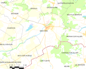
Sancoins
- commune in Cher, France
- Country:
- Postal Code: 18600
- Coordinates: 46° 49' 55" N, 2° 55' 8" E
- GPS tracks (wikiloc): [Link]
- Area: 53.52 sq km
- Population: 3107
- Web site: [Link]
Langeron
- commune in Nièvre, France
- Country:
- Postal Code: 58240
- Coordinates: 46° 48' 40" N, 3° 5' 3" E
- GPS tracks (wikiloc): [Link]
- Area: 20.26 sq km
- Population: 382

Château-sur-Allier
- commune in Allier, France
- Country:
- Postal Code: 03320
- Coordinates: 46° 45' 57" N, 3° 1' 44" E
- GPS tracks (wikiloc): [Link]
- Area: 27.75 sq km
- Population: 179