Nideggen (Nideggen)
- town in the Düren district, in North Rhine-Westphalia, Germany
Nideggen, located in the North Rhine-Westphalia region of Germany, is a beautiful area for hiking enthusiasts, offering a mix of picturesque landscapes, historical sites, and well-maintained trails. Here are some highlights and tips for hiking in and around Nideggen:
Hiking Trails
-
Eifel National Park: Nideggen is close to the Eifel National Park, known for its rich natural beauty, diverse flora and fauna, and extensive trail network. The park features varying landscapes, including forests, moors, and lakes. Popular trails include the "Wildnis-Trail" and the "Ahr-Steig."
-
Burgruine Nideggen: A hike to the Nideggen Castle ruins offers a blend of history and breathtaking views over the Rur Valley. The castle is a great starting point for exploring nearby trails.
-
The Rur River: There are various scenic routes along the Rur River that allow for leisurely hikes with beautiful views of the river and surrounding countryside. You can also enjoy activities like birdwatching and photography.
-
The "Nideggen Erlebnisweg" (Experience Trail): This trail provides insight into local history, culture, and nature, making it a great option for family hikes.
Tips for Hiking in Nideggen
-
Seasonal Considerations: The best times for hiking in this area are spring and fall when temperatures are mild, and the landscapes are particularly vibrant. Summer can be warm, while winter might bring snow, affecting trail conditions.
-
Trail Maps: Make sure to carry a map or download trail apps before heading out, as some trails may not be well-marked.
-
Gear: Wear appropriate footwear and clothing, and pack hiking essentials such as water, snacks, a first-aid kit, and a mobile phone with a portable charger.
-
Wildlife and Nature: Keep an eye out for local wildlife, and remember to respect nature by staying on marked trails and following leave-no-trace principles.
Conclusion
Nideggen offers an ideal blend of natural beauty and historical charm, making it a fantastic destination for hikers of all levels. Whether you're looking for a leisurely stroll or a more challenging hike, you're sure to find a suitable path in this scenic region.
- Country:

- Postal Code: 52385
- Local Dialing Code: 02474; 02427; 02425
- Licence Plate Code: DN
- Coordinates: 50° 42' 0" N, 6° 29' 0" E


- GPS tracks (wikiloc): [Link]
- AboveSeaLevel: 312 м m
- Area: 65.04 sq km
- Population: 9855
- Web site: http://www.nideggen.de
- Wikipedia en: wiki(en)
- Wikipedia: wiki(de)
- Wikidata storage: Wikidata: Q200105
- Wikipedia Commons Category: [Link]
- Wikipedia Commons Maps Category: [Link]
- Freebase ID: [/m/0bflr5]
- GeoNames ID: Alt: [6557531]
- BnF ID: [15301391k]
- VIAF ID: Alt: [159850684]
- OSM relation ID: [163312]
- GND ID: Alt: [4042169-7]
- Library of Congress authority ID: Alt: [n93009732]
- MusicBrainz area ID: [81cc5225-e395-45fc-93a8-4444450ff444]
- WOEID: [679219]
- Quora topic ID: [Nideggen]
- Historical Gazetteer (GOV) ID: [NIDGENJO30FQ]
- National Library of Israel ID: [001031995]
- FAST ID: [1264065]
- German municipality key: 05358044
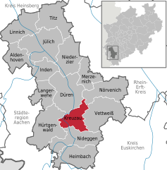
Shares border with regions:


Hürtgenwald
- municipality in the Düren district, in North Rhine-Westphalia, Germany
Hürtgenwald, located in North Rhine-Westphalia, Germany, is known for its lush forests, rolling hills, and rich history, making it a fantastic destination for hikers. The area is characterized by its dense woodlands and diverse flora and fauna, offering a peaceful environment for outdoor enthusiasts. Here’s what you need to know about hiking in Hürtgenwald:...
- Country:

- Postal Code: 52393
- Local Dialing Code: 02429
- Licence Plate Code: DN
- Coordinates: 50° 43' 0" N, 6° 22' 0" E


- GPS tracks (wikiloc): [Link]
- AboveSeaLevel: 380 м m
- Area: 88.05 sq km
- Population: 8644
- Web site: [Link]


Kreuzau
- municipality in the Düren district, in North Rhine-Westphalia, Germany
Kreuzau, located in Germany’s North Rhine-Westphalia region, offers a variety of outdoor activities, including hiking. While it may not be as widely known for hiking as some larger national parks, it does have beautiful landscapes and scenic routes that nature enthusiasts can enjoy. Here are some key points to consider for hiking in and around Kreuzau:...
- Country:

- Postal Code: 52372
- Local Dialing Code: 02427; 02422; 02421
- Licence Plate Code: DN
- Coordinates: 50° 44' 49" N, 6° 29' 26" E


- GPS tracks (wikiloc): [Link]
- AboveSeaLevel: 148 м m
- Area: 41.77 sq km
- Population: 17582
- Web site: [Link]


Vettweiß
- municipality in the Düren district, in North Rhine-Westphalia, Germany
Vettweiß, located in North Rhine-Westphalia, Germany, offers a variety of hiking opportunities that allow you to enjoy the scenic beauty of the region. While Vettweiß itself may not be a major hiking destination, its surrounding areas are quite attractive for outdoor enthusiasts. Here are some aspects to consider when hiking in and around Vettweiß:...
- Country:

- Postal Code: 52391
- Local Dialing Code: 02425; 02424; 02252
- Licence Plate Code: DN
- Coordinates: 50° 44' 0" N, 6° 36' 0" E


- GPS tracks (wikiloc): [Link]
- AboveSeaLevel: 158 м m
- Area: 83.15 sq km
- Population: 9280
- Web site: [Link]


Heimbach
- town in the Düren district, in North Rhine-Westphalia, Germany
Heimbach, located in the Eifel region of Germany, is a fantastic destination for hiking enthusiasts. It offers a diverse range of trails that cater to various skill levels, from gentle walks to more challenging hikes. Here are some highlights of hiking in Heimbach:...
- Country:

- Postal Code: 52396
- Local Dialing Code: 02425; 02446
- Licence Plate Code: DN
- Coordinates: 50° 37' 59" N, 6° 28' 59" E


- GPS tracks (wikiloc): [Link]
- AboveSeaLevel: 227 м m
- Area: 64.8 sq km
- Population: 4319
- Web site: [Link]


Simmerath
- municipality in the district of Aachen, in North Rhine-Westphalia, Germany
Simmerath is a picturesque town located in the Eifel region of Germany, known for its stunning landscapes and rich natural beauty, making it an excellent destination for hiking enthusiasts. Here are some highlights regarding hiking in and around Simmerath:...
- Country:

- Postal Code: 52152
- Local Dialing Code: 02473
- Licence Plate Code: AC
- Coordinates: 50° 36' 0" N, 6° 17' 59" E


- GPS tracks (wikiloc): [Link]
- AboveSeaLevel: 280 м m
- Area: 110.92 sq km
- Population: 15094
- Web site: [Link]


