
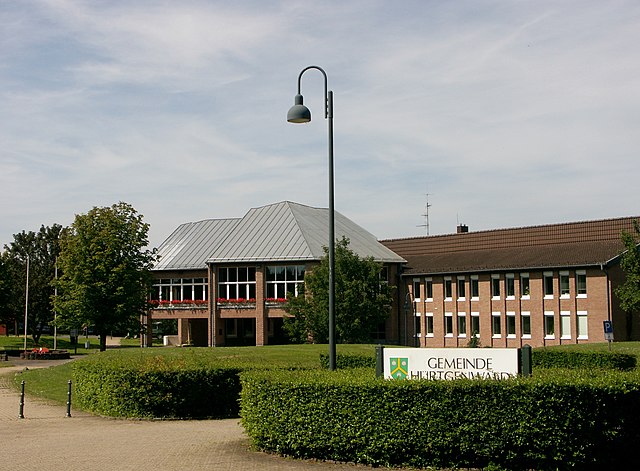
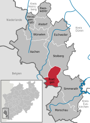
Simmerath (Simmerath)
.svg)
- municipality in the district of Aachen, in North Rhine-Westphalia, Germany
 Hiking in Simmerath
Simmerath is a picturesque town located in the Eifel region of Germany, known for its stunning landscapes and rich natural beauty, making it an excellent destination for hiking enthusiasts. Here are some highlights regarding hiking in and around Simmerath:
Scenic Trails
-
Vennbahn Trail: This is a popular long-distance cycling and hiking route that follows an old railway line through picturesque forests and fields. The flat terrain makes it accessible for hikers of all levels.
-
Eifel National Park: Located nearby, this park offers numerous hiking trails through pristine nature, including diverse flora and fauna, dense forests, and beautiful lakes. Trails range from easy walks to more challenging hikes.
-
Rur Dam and Lake: The area around Rur Dam features several walking paths along the water, offering stunning views and opportunities to enjoy the peaceful surroundings.
Trail Difficulty
The trails in the Simmerath region vary from easy to moderate difficulty. It’s possible to find short loops that are family-friendly or longer trails for experienced hikers looking for a challenge.
Best Time to Hike
The best time for hiking in Simmerath is typically from spring to autumn, with late spring offering particularly beautiful scenery due to blooming wildflowers. Fall also provides a stunning display of colorful foliage.
Tips for Hiking in Simmerath
- Proper Footwear: Wear good hiking boots for comfort and support, as some trails may be uneven or rugged.
- Weather Preparedness: Check the weather forecast and dress in layers to accommodate changing conditions.
- Hydration and Snacks: Bring plenty of water and some snacks to keep your energy levels up.
- Navigation: While many trails are well-marked, carrying a map or GPS device is advisable for less-developed paths.
Local Advice
Consider stopping by the local tourist information center in Simmerath for maps, recommendations on trails, and any guided hikes that may be available. Additionally, engaging with local hiking clubs can enhance your experience and provide insights into hidden gems in the area.
Simmerath and its surroundings offer fantastic opportunities for hiking, making it a lovely escape for nature lovers and outdoor enthusiasts. Enjoy your adventure in the Eifel region!
- Country:

- Postal Code: 52152
- Local Dialing Code: 02473
- Licence Plate Code: AC
- Coordinates: 50° 36' 0" N, 6° 17' 59" E


- GPS tracks (wikiloc): [Link]
- AboveSeaLevel: 280 м m
- Area: 110.92 sq km
- Population: 15094
- Web site: http://www.simmerath.de
- Wikipedia en: wiki(en)
- Wikipedia: wiki(de)
- Wikidata storage: Wikidata: Q200836
- Wikipedia Commons Category: [Link]
- Freebase ID: [/m/0bfhvv]
- GeoNames ID: Alt: [6553052]
- VIAF ID: Alt: [241431843]
- OSM relation ID: [158021]
- GND ID: Alt: [4055043-6]
- archINFORM location ID: [11930]
- MusicBrainz area ID: [963f2f2b-455b-489a-b2b9-cc01c7039783]
- WOEID: [695095]
- Historical Gazetteer (GOV) ID: [SIMATHJO30DO]
- DMOZ ID: Alt: [World/Deutsch/Regional/Europa/Deutschland/Nordrhein-Westfalen/Landkreise/Städteregion_Aachen/Städte_und_Gemeinden/Simmerath/]
- German municipality key: 05334028
Shares border with regions:

Hürtgenwald
- municipality in the Düren district, in North Rhine-Westphalia, Germany
Hiking in Hürtgenwald
Hürtgenwald, located in North Rhine-Westphalia, Germany, is known for its lush forests, rolling hills, and rich history, making it a fantastic destination for hikers. The area is characterized by its dense woodlands and diverse flora and fauna, offering a peaceful environment for outdoor enthusiasts. Here’s what you need to know about hiking in Hürtgenwald:...
- Country:
- Postal Code: 52393
- Local Dialing Code: 02429
- Licence Plate Code: DN
- Coordinates: 50° 43' 0" N, 6° 22' 0" E
- GPS tracks (wikiloc): [Link]
- AboveSeaLevel: 380 м m
- Area: 88.05 sq km
- Population: 8644
- Web site: [Link]


Nideggen
- town in the Düren district, in North Rhine-Westphalia, Germany
Hiking in Nideggen
Nideggen, located in the North Rhine-Westphalia region of Germany, is a beautiful area for hiking enthusiasts, offering a mix of picturesque landscapes, historical sites, and well-maintained trails. Here are some highlights and tips for hiking in and around Nideggen:...
- Country:
- Postal Code: 52385
- Local Dialing Code: 02474; 02427; 02425
- Licence Plate Code: DN
- Coordinates: 50° 42' 0" N, 6° 29' 0" E
- GPS tracks (wikiloc): [Link]
- AboveSeaLevel: 312 м m
- Area: 65.04 sq km
- Population: 9855
- Web site: [Link]


Heimbach
- town in the Düren district, in North Rhine-Westphalia, Germany
Hiking in Heimbach
Heimbach, located in the Eifel region of Germany, is a fantastic destination for hiking enthusiasts. It offers a diverse range of trails that cater to various skill levels, from gentle walks to more challenging hikes. Here are some highlights of hiking in Heimbach:...
- Country:
- Postal Code: 52396
- Local Dialing Code: 02425; 02446
- Licence Plate Code: DN
- Coordinates: 50° 37' 59" N, 6° 28' 59" E
- GPS tracks (wikiloc): [Link]
- AboveSeaLevel: 227 м m
- Area: 64.8 sq km
- Population: 4319
- Web site: [Link]

Roetgen
- municipality in the district of Aachen, in North Rhine-Westphalia, Germany
Hiking in Roetgen
Roetgen, located in North Rhine-Westphalia, Germany, is a picturesque town that serves as an excellent base for hiking enthusiasts. Nestled near the border with Belgium and surrounded by the stunning landscapes of the Eifel region, it offers a variety of trails suitable for different skill levels. Here are some highlights for hiking in Roetgen:...
- Country:
- Postal Code: 52159
- Local Dialing Code: 02471
- Licence Plate Code: AC
- Coordinates: 50° 39' 0" N, 6° 12' 0" E
- GPS tracks (wikiloc): [Link]
- AboveSeaLevel: 410 м m
- Area: 39.03 sq km
- Population: 8625
- Web site: [Link]


Monschau
- city in the district of Aachen, in North Rhine-Westphalia, Germany
Hiking in Monschau
Monschau, a picturesque town in the Eifel region of Germany, is a fantastic destination for hiking enthusiasts. Nestled in a narrow valley, this charming town is renowned for its half-timbered houses, cobblestone streets, and beautiful natural landscape, making it an ideal starting point for various hiking trails....
- Country:
- Postal Code: 52156
- Local Dialing Code: 02472
- Coordinates: 50° 33' 0" N, 6° 15' 0" E
- GPS tracks (wikiloc): [Link]
- AboveSeaLevel: 517 м m
- Area: 94.6 sq km
- Population: 12352
- Web site: [Link]

Stolberg
- city in the district of Aachen, in North Rhine-Westphalia, Germany
Hiking in Stolberg
Stolberg is located in the Rhineland region of Germany and is surrounded by beautiful landscapes that are perfect for hiking enthusiasts. Here are some highlights and tips for hiking in and around Stolberg:...
- Country:
- Postal Code: 52224; 52223; 52222
- Local Dialing Code: 02409; 02408; 02402
- Licence Plate Code: AC
- Coordinates: 50° 46' 0" N, 6° 14' 0" E
- GPS tracks (wikiloc): [Link]
- AboveSeaLevel: 260 м m
- Area: 98.48 sq km
- Population: 56751
- Web site: [Link]