
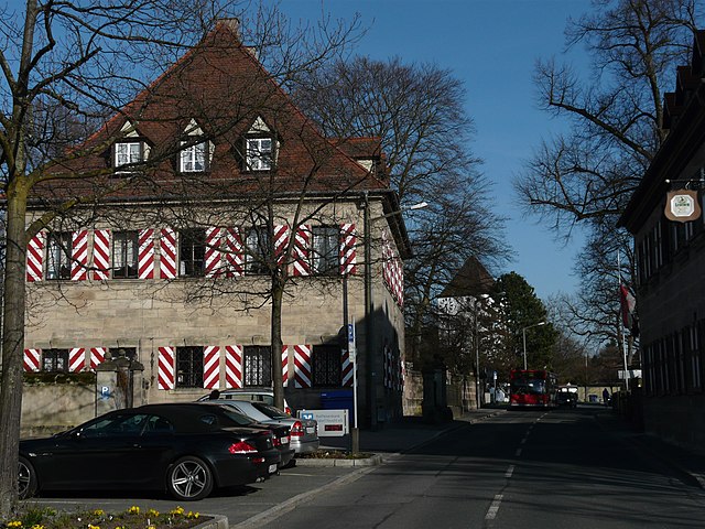
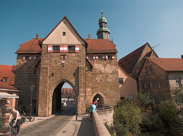
Nuremberg (Nürnberg)


- city in the German state of Bavaria
 Hiking in Nuremberg
Hiking in and around Nuremberg can offer a remarkable blend of urban exploration and natural beauty. Though Nuremberg itself is a city with a rich history, it is surrounded by picturesque landscapes that are perfect for hiking enthusiasts. Here are some highlights and tips for hiking in the region:
Local Parks and Trails
-
Luitpoldhain: This large park offers a pleasant area for shorter walks, featuring scenic pathways, gardens, and views of the city.
-
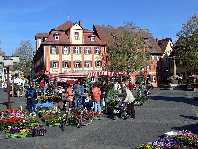
Nuremberg Castle Trails: The historic castle located at the heart of the city provides a unique opportunity to combine historical exploration with gentle hikes around the castle grounds and the surrounding old town.
-
Wöhrder See: This beautiful lake has surrounding paths that are ideal for leisurely walks and offer scenic views, especially at sunset.
-
Valley of the Pegnitz: The Pegnitz River runs through Nuremberg, and the trails along the riverbanks provide a relaxing hiking experience right in the city.
Nearby Hiking Areas
For more extensive or challenging hikes, you can explore areas just outside of Nuremberg:
-
Frankenjura: A renowned climbing and hiking area to the northeast of Nuremberg, it features spectacular rock formations and numerous marked trails suitable for different skill levels.
-
The Fichtel Mountains: Located a bit further away, this mountain range offers well-marked trails, varying in difficulty, with stunning views and a chance to experience nature more remotely.
-
Nuremberg Woods (Nürnberger Reichswald): This expansive forest area offers a network of trails where you can hike amidst lush greenery, enjoy diverse flora and fauna, and take in fresh air.
Tips for Hiking in Nuremberg
-
Weather Considerations: Always check the weather forecast beforehand, as conditions can change rapidly, especially in wooded areas.
-
Trail Maps and Apps: Utilize local hiking apps or trail maps to find marked paths; many are well-signposted.
-
Safety: Carry adequate water, snacks, and a basic first-aid kit. Inform someone about your hiking plans, especially if venturing into less populated areas.
-
Public Transport: Nuremberg has robust public transport, making it convenient to access nearby hiking trails.
-
Local Regulations: Familiarize yourself with any local guidelines or regulations regarding hiking, especially in protected areas.
Conclusion
Hiking around Nuremberg presents a great way to enjoy the fresh air, scenic views, and the history of the region. Whether you prefer a casual stroll through city parks or a more challenging trek in nearby natural reserves, there are plenty of opportunities to explore the beauty of this vibrant region!
- Country:

- Postal Code: 90402–90491
- Local Dialing Code: 0911
- Licence Plate Code: N
- Coordinates: 49° 27' 10" N, 11° 4' 40" E


- GPS tracks (wikiloc): [Link]
- AboveSeaLevel: 209 м m
- Area: 186.45 sq km
- Population: 515201
- Web site: https://www.nuernberg.de/
- Wikipedia en: wiki(en)
- Wikipedia: wiki(de)
- Wikidata storage: Wikidata: Q2090
- Wikipedia Commons Gallery: [Link]
- Wikipedia Commons Category: [Link]
- Wikipedia Commons Maps Category: [Link]
- Freebase ID: [/m/05bkf]
- GeoNames ID: Alt: [2861650]
- BnF ID: [11865133c]
- VIAF ID: Alt: [155319007]
- OSM relation ID: [62780]
- GND ID: Alt: [4042742-0]
- archINFORM location ID: [264]
- Library of Congress authority ID: Alt: [n80017681]
- MusicBrainz area ID: [9b9dd8cc-0ed0-4b29-8b50-90c1a61e16ae]
- WOEID: [680564]
- Quora topic ID: [Nürnberg-Germany]
- TGN ID: [7004334]
- SUDOC authorities ID: [026396122]
- Encyclopædia Britannica Online ID: [place/Nurnberg]
- Encyclopædia Universalis ID: [nuremberg]
- HDS ID: [6601]
- EMLO location ID: [53985e7b-dced-4cb1-b213-5dab0fdcc5b1]
- Facebook Places ID: [103976586304604]
- Great Russian Encyclopedia Online ID: [2281738]
- Bavarikon ID: [ODB_A00000009]
- ISNI: Alt: [0000 0001 2170 3483]
- NKCR AUT ID: [ge130187]
- DMOZ ID: Alt: [World/Deutsch/Regional/Europa/Deutschland/Bayern/Städte_und_Gemeinden/N/Nürnberg/]
- National Library of Israel ID: [000978339]
- NUTS code: [DE254]
- YSO ID: [127419]
- Nomisma ID: [nuremberg]
- Klexikon article ID: [Nürnberg]
- BabelNet ID: [00058323n]
- FAST ID: [1207726]
- Catholic Encyclopedia ID: [11168a]
- Comic Vine ID: [4020-59787]
- German municipality key: 09564000
- US National Archives Identifier: 10044898
- German district key: 09564
Includes regions:
Doos
- human settlement in Germany
Hiking in Doos
Hiking in Doos, particularly in the Muggenhof area, offers a delightful experience for nature enthusiasts. Located in Belgium, this region is known for its scenic landscapes, wooded areas, and walking trails that cater to various skill levels....
- Country:
- Postal Code: 90429
- Local Dialing Code: 0911
- Coordinates: 49° 27' 44" N, 11° 1' 17" E
- GPS tracks (wikiloc): [Link]
Glockenhof
- district of Nuremberg
Hiking in Glockenhof
Glockenhof is not a widely recognized hiking destination, and it appears that you may be referring to a specific area named Glockenhof, which could potentially be a locality or region in certain countries, particularly in German-speaking areas. However, assuming you're interested in hiking in a scenic or rural area often associated with the name, I can provide general tips on what to consider when hiking in such areas, as well as what typically might be expected....
- Country:
- Postal Code: 90487
- Coordinates: 49° 27' 10" N, 11° 2' 59" E
- GPS tracks (wikiloc): [Link]
- Area: 0.8300 sq km


Eberhardshof
Hiking in Eberhardshof
Eberhardshof is a small village located in Germany, likely in the context of the region of Bavaria. When hiking in this area, you can expect to find picturesque landscapes, lush greenery, and possibly some historical sites or trails that reflect the local culture and natural beauty....
- Country:
- Postal Code: 90431
- Coordinates: 49° 27' 28" N, 11° 1' 40" E
- GPS tracks (wikiloc): [Link]
- Area: 1.2334 sq km
Freilandsiedlung
- human settlement in Germany
Hiking in Freilandsiedlung
Freilandsiedlung is a small community located in Austria, and while it may not be as widely known for hiking as some of the larger mountain regions, there are certainly opportunities to explore the natural beauty in and around the area. Here are some general tips and information regarding hiking in Freilandsiedlung:...
- Country:
- Postal Code: 90482
- Local Dialing Code: 0911
- Coordinates: 49° 27' 10" N, 11° 2' 59" E
- GPS tracks (wikiloc): [Link]
Fischbach
- district of Nuremberg
Hiking in Fischbach
Fischbach bei Nürnberg is a charming district located in the northern part of Nuremberg, Germany. It offers a variety of scenic hiking trails that are perfect for nature lovers and outdoor enthusiasts. Here are some highlights and tips for hiking in this area:...
- Country:
- Postal Code: 90475
- Local Dialing Code: 0911
- Coordinates: 49° 25' 16" N, 11° 11' 37" E
- GPS tracks (wikiloc): [Link]
- AboveSeaLevel: 344 м m
- Area: 2.6094 sq km


Eibach
Hiking in Eibach
Eibach, a district of Nürnberg in Germany, provides access to some lovely hiking opportunities in and around the area, particularly as it is situated near the Franconian countryside. While Eibach itself is more urban, the surrounding regions offer a variety of trails suited for different skill levels....
- Country:
- Postal Code: 90451
- Coordinates: 49° 24' 15" N, 11° 2' 13" E
- GPS tracks (wikiloc): [Link]
- AboveSeaLevel: 308 м m
Eichenlöhlein
Hiking in Eichenlöhlein
Eichenlöhlein is a picturesque area, often noted for its scenic landscapes and diverse trails, though it might not be as well-known as some larger national parks or hiking destinations. When hiking in such areas, you can generally expect:...
- Country:
- Postal Code: 90455
- Coordinates: 49° 26' 42" N, 11° 7' 42" E
- GPS tracks (wikiloc): [Link]
Gerasmühle
- human settlement in Germany
Hiking in Gerasmühle
Gerasmühle, located in Germany, is known for its picturesque landscapes and scenic hiking trails. While specific information about hiking in Gerasmühle may not be widely available, it’s likely that the area offers nature trails that provide a mix of serene woodland walks and more challenging paths for avid hikers....
- Country:
- Local Dialing Code: 0911
- Coordinates: 49° 27' 10" N, 11° 2' 59" E
- GPS tracks (wikiloc): [Link]

Erlenstegen
Hiking in Erlenstegen
Erlenstegen, located in the Nuremberg area of Germany, offers a variety of hiking opportunities that cater to different skill levels. The region is characterized by its scenic landscapes, including lush forests, rolling hills, and picturesque valleys....
- Country:
- Postal Code: 90491
- Coordinates: 49° 28' 28" N, 11° 8' 24" E
- GPS tracks (wikiloc): [Link]
- Area: 3.4355 sq km

Falkenheim
- human settlement in Germany
Hiking in Falkenheim
Falkenheim is a beautiful destination for hiking enthusiasts, offering a range of trails suited for various skill levels. Located in the picturesque landscape of Germany, particularly within the Bavarian Alps region, Falkenheim serves as a gateway to breathtaking views, diverse wildlife, and lush forests....
- Country:
- Postal Code: 90469
- Local Dialing Code: 0911
- Coordinates: 49° 24' 9" N, 11° 5' 12" E
- GPS tracks (wikiloc): [Link]
Galgenhof
Hiking in Galgenhof
Galgenhof is a lesser-known area, so details might be limited depending on the specific region you’re referring to. However, if you're talking about hiking in the vicinity of the Galgenhof area in Germany, typically you can expect a mix of urban and natural landscapes....
- Country:
- Postal Code: 90459
- Coordinates: 49° 26' 21" N, 11° 4' 56" E
- GPS tracks (wikiloc): [Link]


Gartenstadt
Hiking in Gartenstadt
Gartenstadt is a picturesque district located in Nürnberg, Germany, known for its charming residential areas and green spaces. While it may not be renowned for extensive hiking trails, it offers several opportunities for nature walks and light hiking, particularly for those looking to enjoy the outdoors in a more urban setting....
- Country:
- Postal Code: 90469
- Coordinates: 49° 24' 48" N, 11° 4' 42" E
- GPS tracks (wikiloc): [Link]
- Area: 3.1284 sq km

Gaulnhofen
- district of Nuremberg
Hiking in Gaulnhofen
Gaulnhofen is a small village located in Bavaria, Germany. While it may not be as well-known as some of the larger hiking destinations in the region, it offers opportunities for those looking to explore the natural beauty of the area. Here are some considerations for hiking in and around Gaulnhofen:...
- Country:
- Postal Code: 90455
- Local Dialing Code: 0911
- Coordinates: 49° 21' 50" N, 11° 4' 32" E
- GPS tracks (wikiloc): [Link]
- AboveSeaLevel: 345 м m


Gebersdorf
- district of Nuremberg
Hiking in Gebersdorf
Gebersdorf, located in the northeastern part of Nürnberg (Nuremberg), is not primarily known as a hiking destination; however, it is surrounded by beautiful landscapes that can be explored on foot. Here are some points to consider if you're looking to hike in or around Gebersdorf:...
- Country:
- Postal Code: 90449
- Coordinates: 49° 25' 48" N, 11° 0' 31" E
- GPS tracks (wikiloc): [Link]


Gibitzenhof
Hiking in Gibitzenhof
Gibitzenhof is a lovely area located near the city of Nuremberg in Germany, known for its natural beauty and hiking opportunities. Here’s what you can look forward to when hiking in and around Gibitzenhof:...
- Country:
- Postal Code: 90441
- Coordinates: 49° 25' 40" N, 11° 3' 56" E
- GPS tracks (wikiloc): [Link]
Gleißbühl
- human settlement in Germany
Hiking in Gleißbühl
Gleißbühl, located in Germany, is a lesser-known but charming area for hiking enthusiasts. Situated in the region of Bavaria, it offers picturesque landscapes, including rolling hills, dense forests, and serene meadows. Hiking in Gleißbühl can be a peaceful experience, ideal for those looking to escape the hustle and bustle of city life....
- Country:
- Local Dialing Code: 0911
- Coordinates: 49° 27' 10" N, 11° 2' 59" E
- GPS tracks (wikiloc): [Link]


Gostenhof
Hiking in Gostenhof
Gostenhof is a district in the city of Nuremberg, Germany. While it is primarily an urban area, it's close to various hiking opportunities in the surrounding region. If you're looking to explore nature while in or near Gostenhof, here are some options:...
- Country:
- Postal Code: 90429
- Coordinates: 49° 26' 48" N, 11° 3' 32" E
- GPS tracks (wikiloc): [Link]
- AboveSeaLevel: 315 м m
- Area: 0.5180 sq km
Greuth
- district of Nuremberg
Hiking in Greuth
Greuth is a charming district located in the city of Nürnberg, Germany. While it's mainly urban, there are opportunities for walking and hiking in and around the area, providing lovely views and the chance to explore nature....
- Country:
- Postal Code: 90455
- Local Dialing Code: 0911
- Coordinates: 49° 20' 43" N, 11° 4' 49" E
- GPS tracks (wikiloc): [Link]
- AboveSeaLevel: 341 м m

Großreuth bei Schweinau
- district of Nuremberg
Hiking in Großreuth bei Schweinau
Großreuth bei Schweinau, located in the region of Bavaria, Germany, offers various hiking opportunities that cater to different skill levels. While the area is more urbanized than some rural hiking destinations, it still provides access to scenic routes and nearby natural landscapes....
- Country:
- Postal Code: 90439
- Coordinates: 49° 26' 4" N, 11° 1' 22" E
- GPS tracks (wikiloc): [Link]
Gärten hinter der Veste
- human settlement in Germany
Hiking in Gärten hinter der Veste
Gärten hinter der Veste, located in Nuremberg, Germany, is a beautiful urban park that offers a unique blend of nature and historical relevance. While it might not be a traditional hiking destination, there are several enjoyable walking and exploring opportunities within the park. Here’s what you can expect:...
- Country:
- Postal Code: 90408
- Local Dialing Code: 0911
- Coordinates: 49° 27' 38" N, 11° 4' 54" E
- GPS tracks (wikiloc): [Link]
- Area: 1.08 sq km

Buch
Hiking in Buch
Buch, a district in Nürnberg (Nuremberg), offers a refreshing glimpse of nature just outside an urban environment. While it's primarily a residential area, there are several opportunities for hiking and enjoying the outdoors nearby....
- Country:
- Postal Code: 90427
- Coordinates: 49° 29' 48" N, 11° 2' 43" E
- GPS tracks (wikiloc): [Link]
- AboveSeaLevel: 305 м m
- Area: 3.08 sq km
Wöhrd
Hiking in Wöhrd
Wöhrd is a district located in the city of Regensburg, Germany, and is situated along the banks of the Danube River. While Wöhrd itself is more urbanized, it is close to some beautiful natural areas that offer hiking opportunities....
- Country:
- Coordinates: 49° 27' 15" N, 11° 5' 45" E
- GPS tracks (wikiloc): [Link]


Altenfurt
- district of Nuremberg
Hiking in Altenfurt
Altenfurt is a district located in the city of Nürnberg (Nuremberg), Germany. While it's primarily known as a residential area, hiking opportunities can be found in the surrounding region....
- Country:
- Postal Code: 90475
- Local Dialing Code: 0911
- Coordinates: 49° 24' 23" N, 11° 10' 27" E
- GPS tracks (wikiloc): [Link]
- AboveSeaLevel: 340 м m


Almoshof
- statistical district of Nuremberg
Hiking in Almoshof
Almoshof is a district located in the city of Nuremberg, Germany. While it's primarily an urban area, it does have access to green spaces and nearby hiking opportunities. Here’s a general overview of what you can expect when hiking around Almoshof and its surroundings:...
- Country:
- Postal Code: 90427
- Coordinates: 49° 29' 29" N, 11° 3' 41" E
- GPS tracks (wikiloc): [Link]
- AboveSeaLevel: 310 м m
- Area: 2.453 sq km


Gleisshammer
- district of Nuremberg, Germany
Hiking in Gleisshammer
Gleißhammer is a scenic area located in Bavaria, Germany, near the city of Nuremberg. While it may not be as prominent as some of the larger national parks, there are definitely opportunities for hiking and enjoying the natural beauty of the surrounding landscape....
- Country:
- Postal Code: 90478
- Coordinates: 49° 26' 46" N, 11° 7' 0" E
- GPS tracks (wikiloc): [Link]
- Area: 0.942 sq km
Bleiweiß
- human settlement in Germany
Hiking in Bleiweiß
Bleiweiß is a lovely area located near Nürnberg, Germany, that offers a variety of hiking trails and scenic views. While it may not be as well-known as some national parks or more extensive hiking areas, the region is ideal for both short walks and longer hikes, allowing you to explore the beautiful Bavarian landscape....
- Country:
- Local Dialing Code: 0911
- Coordinates: 49° 27' 10" N, 11° 2' 59" E
- GPS tracks (wikiloc): [Link]


Boxdorf
- district of Nuremberg
Hiking in Boxdorf
Boxdorf is a district located in the northern part of Nürnberg, Germany. While it may not be widely recognized as a primary hiking destination, it offers access to some pleasant hiking trails and natural scenery in the surrounding areas. Here are some key points to consider when hiking in and around Boxdorf:...
- Country:
- Postal Code: 90427
- Local Dialing Code: 0911
- Coordinates: 49° 30' 59" N, 11° 1' 29" E
- GPS tracks (wikiloc): [Link]
- AboveSeaLevel: 299 м m
- Area: 3.4029 sq km


Großgründlach
- district of Nuremberg
Hiking in Großgründlach
Großgründlach is a picturesque district in the city of Nürnberg, Germany, known for its beautiful countryside and scenic hiking trails. The area offers a mix of wooded areas, fields, and picturesque landscapes, making it a great destination for hikers of all levels. Here are a few key points to consider when hiking in Großgründlach:...
- Country:
- Postal Code: 90427
- Local Dialing Code: 0911
- Coordinates: 49° 31' 38" N, 11° 0' 30" E
- GPS tracks (wikiloc): [Link]
- AboveSeaLevel: 302 м m
- Area: 5.0852 sq km

Brunn
- district of Nuremberg
Hiking in Brunn
Brunn, a district of Nürnberg, Germany, offers a delightful experience for hikers looking to explore the natural beauty of the region. Although Brunn itself may not have extensive hiking trails, it is conveniently located near several areas with great hiking opportunities....
- Country:
- Postal Code: 90475
- Local Dialing Code: 0911
- Coordinates: 49° 26' 9" N, 11° 15' 10" E
- GPS tracks (wikiloc): [Link]
- AboveSeaLevel: 372 м m
- Area: 0.79 sq km

Buchenbühl
Hiking in Buchenbühl
Buchenbühl, located in Germany, offers beautiful hiking opportunities for nature enthusiasts of all skill levels. The area is characterized by lush forests, scenic views, and well-maintained trails that allow hikers to immerse themselves in the natural beauty of the region....
- Country:
- Postal Code: 90411
- Coordinates: 49° 30' 15" N, 11° 6' 36" E
- GPS tracks (wikiloc): [Link]
- AboveSeaLevel: 338 м m
Shares border with regions:

Erlangen-Höchstadt
- district in Bavaria, Germany
Hiking in Erlangen-Höchstadt
Erlangen-Höchstadt is a scenic district in Bavaria, Germany, known for its beautiful landscapes and opportunities for outdoor activities, including hiking. The region offers a mix of rolling hills, woodlands, and agricultural fields, making it suitable for both casual and more adventurous hikers....
- Country:
- Capital: Erlangen
- Licence Plate Code: ERH
- Coordinates: 49° 40' 12" N, 10° 49' 48" E
- GPS tracks (wikiloc): [Link]
- AboveSeaLevel: 287 м m
- Area: 56465.80 sq km
- Population: 134136
- Web site: [Link]
Nürnberger Land
- district in Bavaria, Germany
Hiking in Nürnberger Land
Nürnberger Land, located in Bavaria, Germany, is a fantastic area for hiking enthusiasts. It features a diverse landscape that includes forests, hills, and picturesque valleys, making it ideal for both casual walkers and seasoned hikers. Here are some key points about hiking in Nürnberger Land:...
- Country:
- Capital: Lauf an der Pegnitz
- Licence Plate Code: PEG; N; LAU; HEB; ESB
- Coordinates: 49° 30' 0" N, 11° 22' 0" E
- GPS tracks (wikiloc): [Link]
- AboveSeaLevel: 355 м m
- Area: 800.00 sq km
- Population: 149127
- Web site: [Link]

Roth
- district in Bavaria, Germany
Hiking in Roth
Roth district, located in Bavaria, Germany, offers a variety of beautiful landscapes and hiking opportunities that appeal to both novice and experienced hikers. The area is characterized by rolling hills, forests, and picturesque views. Here are some highlights and tips for hiking in Roth:...
- Country:
- Capital: Roth
- Licence Plate Code: RH; HIP
- Coordinates: 49° 15' 0" N, 11° 4' 48" E
- GPS tracks (wikiloc): [Link]
- AboveSeaLevel: 355 м m
- Area: 895.00 sq km
- Population: 103944
- Web site: [Link]

Fürth
- district in Bavaria, Germany
Hiking in Fürth
Fürth, located in Bavaria, Germany, offers a variety of hiking opportunities that cater to different skill levels and preferences. The area is characterized by beautiful hills, forests, and rivers, making it a great spot for outdoor enthusiasts....
- Country:
- Capital: Zirndorf
- Licence Plate Code: FÜ
- Coordinates: 49° 25' 0" N, 10° 50' 0" E
- GPS tracks (wikiloc): [Link]
- AboveSeaLevel: 397 м m
- Area: 308.00 sq km
- Population: 116193
- Web site: [Link]
Schwabach
- town in Bavaria, Germany
Hiking in Schwabach
Schwabach, located in the state of Bavaria, Germany, offers a variety of hiking opportunities that showcase the natural beauty and cultural heritage of the region. Here are some highlights for hiking in and around Schwabach:...
- Country:
- Postal Code: 91126
- Local Dialing Code: 0911; 09122
- Licence Plate Code: SC
- Coordinates: 49° 19' 45" N, 11° 1' 15" E
- GPS tracks (wikiloc): [Link]
- AboveSeaLevel: 326 м m
- Area: 40.71 sq km
- Population: 39546
- Web site: [Link]

Fürth
- town in Bavaria, Germany
Hiking in Fürth
Fürth, located in Bavaria, Germany, offers several hiking opportunities that cater to various fitness levels and preferences. While it may not be as well-known as some of the larger cities for hiking, it has its charms and beautiful landscapes....
- Country:
- Postal Code: 90768; 90766; 90765; 90763; 90762
- Local Dialing Code: 0911
- Licence Plate Code: FÜ
- Coordinates: 49° 28' 42" N, 10° 59' 25" E
- GPS tracks (wikiloc): [Link]
- AboveSeaLevel: 296 м m
- Area: 63.35 sq km
- Population: 125403
- Web site: [Link]
Erlangen
- large city in Bavaria, Germany
Hiking in Erlangen
Erlangen, located in Bavaria, Germany, is surrounded by beautiful landscapes that offer various hiking opportunities. While the city itself is relatively flat, the nearby Franconian Switzerland region and the hills of the Fichtelgebirge provide excellent trails for hikers of all skill levels....
- Country:
- Postal Code: 91001; 91058; 91057; 91056; 91055; 91054; 91053; 91052
- Local Dialing Code: 09132; 09135; 0911; 09131
- Licence Plate Code: ER
- Coordinates: 49° 35' 47" N, 11° 0' 16" E
- GPS tracks (wikiloc): [Link]
- AboveSeaLevel: 279 м m
- Area: 76900000 sq km
- Population: 108336
- Web site: [Link]


Oberasbach
- human settlement in Germany
Hiking in Oberasbach
Oberasbach, located in Bavaria, Germany, offers a variety of hiking opportunities set against the backdrop of the beautiful Franconian landscapes. While it might not be as well-known for hiking as some other areas in Bavaria, it still provides access to scenic trails and paths that appeal to nature lovers....
- Country:
- Postal Code: 90522
- Local Dialing Code: 0911
- Coordinates: 49° 25' 19" N, 10° 57' 30" E
- GPS tracks (wikiloc): [Link]
- AboveSeaLevel: 316 м m
- Area: 12.08 sq km
- Population: 14833
- Web site: [Link]