Peia (Peia)
.svg)
- Italian comune
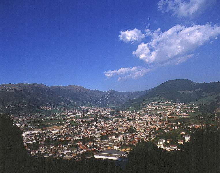
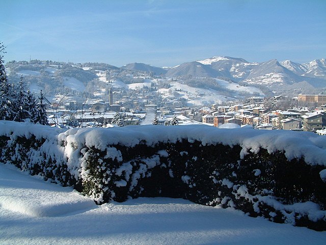
 Hiking in Peia
Peia, located in Italy's Lombardy region near Lake Iseo, is a picturesque area that offers a variety of hiking opportunities. Nestled in the foothills of the Alps, the region boasts beautiful landscapes, stunning views, and charming local villages.
Trail Options
-
Sentiero dei Ghiacciai: This trail offers a stunning view of the glaciers and surrounding mountains. It's suitable for those with moderate hiking experience, as it includes some elevation gain.
-
Lake Iseo Trails: Several trails around Lake Iseo lead to breathtaking vistas of the lake and surrounding hills. The walking paths often connect small villages, allowing you to experience local culture and cuisine.
-
Monte Guglielmo: A more challenging hike, this trail takes you up to Monte Guglielmo, where you'll be rewarded with panoramic views of the region. It's advisable to start early in the day to allow enough time for the summit and descent.
-
Viso Trail: This is a more relaxed hike that winds through beautiful countryside and offers opportunities for birdwatching and photography.
Preparations and Tips
-
Gear: Wear sturdy hiking boots and carry appropriate gear depending on the season. Layers are recommended due to changing weather conditions.
-
Water and Snacks: Bring along enough water and snacks to keep your energy up, especially on longer hikes.
-
Maps and Guides: Although many paths are well-marked, having a local map or guide can enhance safety and help you discover hidden gems.
-
Guided Hikes: If you are unfamiliar with the area, consider joining a guided hiking tour to gain insights into the local flora, fauna, and culture.
Best Time to Hike
The best time for hiking in Peia is typically from spring to early autumn (April to October). During these months, the weather is generally mild and trails are more accessible.
With stunning views and a variety of trails, Peia is an excellent destination for both novice and experienced hikers. Enjoy your adventure!
- Country:

- Postal Code: 24020
- Local Dialing Code: 035
- Licence Plate Code: BG
- Coordinates: 45° 48' 0" N, 9° 54' 0" E


- GPS tracks (wikiloc): [Link]
- AboveSeaLevel: 570 м m
- Area: 4.48 sq km
- Population: 1818
- Web site: http://www.comune.peia.bg.it
- Wikipedia en: wiki(en)
- Wikipedia: wiki(it)
- Wikidata storage: Wikidata: Q101377
- Wikipedia Commons Gallery: [Link]
- Wikipedia Commons Category: [Link]
- Freebase ID: [/m/0gjcpn]
- GeoNames ID: Alt: [6542560]
- OSM relation ID: [46127]
- UN/LOCODE: [ITPEQ]
- ISTAT ID: 016161
- Italian cadastre code: G418
Shares border with regions:

Gandino
- Italian comune
Hiking in Gandino
Gandino is a charming village located in the province of Bergamo, Lombardy, Italy. Nestled in the Seriana Valley and surrounded by stunning mountain landscapes, it offers a variety of hiking opportunities for outdoor enthusiasts. Here are some key aspects to consider when hiking in Gandino:...
- Country:
- Postal Code: 24024
- Local Dialing Code: 035
- Licence Plate Code: BG
- Coordinates: 45° 48' 42" N, 9° 54' 11" E
- GPS tracks (wikiloc): [Link]
- AboveSeaLevel: 553 м m
- Area: 29.03 sq km
- Population: 5390
- Web site: [Link]

Leffe, Lombardy
- Italian comune
Hiking in Leffe, Lombardy
Leffe, located in the Lombardy region of northern Italy, is a charming village situated near Lake Iseo and is surrounded by beautiful natural landscapes, making it an excellent spot for hiking enthusiasts. Here are a few highlights and tips for hiking in and around Leffe:...
- Country:
- Postal Code: 24026
- Local Dialing Code: 035
- Licence Plate Code: BG
- Coordinates: 45° 48' 0" N, 9° 54' 0" E
- GPS tracks (wikiloc): [Link]
- AboveSeaLevel: 453 м m
- Area: 6.69 sq km
- Population: 4463
- Web site: [Link]

Ranzanico
- Italian comune
Hiking in Ranzanico
Ranzanico is a small town located in the province of Bergamo in the Lombardy region of Italy. Nestled near the shores of Lake Endine and surrounded by the picturesque landscapes of the Italian Alps, Ranzanico offers various hiking opportunities that cater to different skill levels....
- Country:
- Postal Code: 24060
- Local Dialing Code: 035
- Licence Plate Code: BG
- Coordinates: 45° 47' 0" N, 9° 56' 0" E
- GPS tracks (wikiloc): [Link]
- AboveSeaLevel: 519 м m
- Area: 7.21 sq km
- Population: 1230
- Web site: [Link]
Bianzano
- Italian comune
Hiking in Bianzano
Bianzano is a charming village located in the province of Bergamo in northern Italy. It is surrounded by beautiful landscapes, making it a great destination for hiking enthusiasts. Here are some highlights and details about hiking in and around Bianzano:...
- Country:
- Postal Code: 24060
- Local Dialing Code: 035
- Licence Plate Code: BG
- Coordinates: 45° 46' 26" N, 9° 55' 10" E
- GPS tracks (wikiloc): [Link]
- AboveSeaLevel: 614 м m
- Area: 6.67 sq km
- Population: 610
- Web site: [Link]