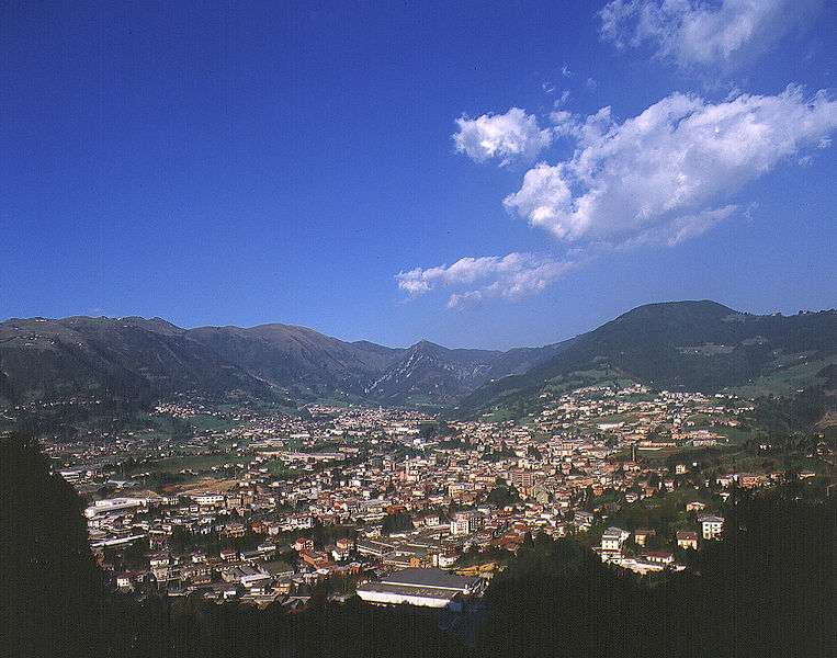
Ranzanico (Ranzanico)
.svg)
- Italian comune
 Hiking in Ranzanico
Ranzanico is a small town located in the province of Bergamo in the Lombardy region of Italy. Nestled near the shores of Lake Endine and surrounded by the picturesque landscapes of the Italian Alps, Ranzanico offers various hiking opportunities that cater to different skill levels.
Key Hiking Areas in Ranzanico:
-
Lake Endine: The area around Lake Endine presents several hiking trails with beautiful views of the lake and surrounding hills. You can enjoy leisurely walks along the shore or more challenging routes that climb into the hills.
-
Monte Misma: This mountain offers a more strenuous hike with rewarding panoramic views of the surrounding areas, including the Alps. The trail is suitable for experienced hikers looking for a full-day adventure.
-
Valle Seriana: A short drive from Ranzanico, this valley has numerous trails that can take you through scenic forests and along rivers, revealing the natural beauty of the region.
-
Sentiero dei Mulini: This "Path of the Mills" is a cultural and historical trail that not only allows for enjoyable hiking but also showcases the traditional water mills that were once prevalent in the area.
Tips for Hiking in Ranzanico:
- Check the Weather: Conditions can change rapidly in the mountains, so it's best to check the forecast before heading out.
- Wear Proper Footwear: Good hiking boots with ankle support are essential for navigating uneven terrain.
- Bring Water and Snacks: Hydrate regularly and pack energy-rich snacks to keep your energy levels up.
- Follow Local Guidelines: Always stick to marked trails and respect nature by not leaving waste behind.
Additional Activities:
Besides hiking, Ranzanico and its surrounding areas offer opportunities for biking, bird watching, and exploring traditional Italian villages. The region is also known for its local cuisine, so be sure to sample some regional dishes at local restaurants.
Whether you are a novice or an experienced hiker, Ranzanico provides a charming escape into nature with stunning views and a chance to immerse yourself in the Italian countryside.
- Country:

- Postal Code: 24060
- Local Dialing Code: 035
- Licence Plate Code: BG
- Coordinates: 45° 47' 0" N, 9° 56' 0" E


- GPS tracks (wikiloc): [Link]
- AboveSeaLevel: 519 м m
- Area: 7.21 sq km
- Population: 1230
- Web site: http://www.comune.ranzanico.bg.it/
- Wikipedia en: wiki(en)
- Wikipedia: wiki(it)
- Wikidata storage: Wikidata: Q101503
- Wikipedia Commons Gallery: [Link]
- Wikipedia Commons Category: [Link]
- Freebase ID: [/m/0gjd8p]
- GeoNames ID: Alt: [6543163]
- VIAF ID: Alt: [245394024]
- OSM relation ID: [46090]
- ISTAT ID: 016179
- Italian cadastre code: H177
Shares border with regions:


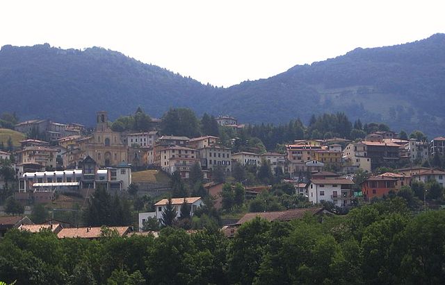
Endine Gaiano
- Italian comune
Hiking in Endine Gaiano
Endine Gaiano is a lovely town located in the province of Bergamo in Italy, situated near the shores of Lake Endine. The area is known for its picturesque landscapes, charming villages, and outdoor recreational opportunities, making it a great destination for hiking enthusiasts....
- Country:
- Postal Code: 24060
- Local Dialing Code: 035
- Licence Plate Code: BG
- Coordinates: 45° 47' 0" N, 9° 58' 0" E
- GPS tracks (wikiloc): [Link]
- AboveSeaLevel: 400 м m
- Area: 21.07 sq km
- Population: 3460
- Web site: [Link]

Gandino
- Italian comune
Hiking in Gandino
Gandino is a charming village located in the province of Bergamo, Lombardy, Italy. Nestled in the Seriana Valley and surrounded by stunning mountain landscapes, it offers a variety of hiking opportunities for outdoor enthusiasts. Here are some key aspects to consider when hiking in Gandino:...
- Country:
- Postal Code: 24024
- Local Dialing Code: 035
- Licence Plate Code: BG
- Coordinates: 45° 48' 42" N, 9° 54' 11" E
- GPS tracks (wikiloc): [Link]
- AboveSeaLevel: 553 м m
- Area: 29.03 sq km
- Population: 5390
- Web site: [Link]


Monasterolo del Castello
- Italian comune
Hiking in Monasterolo del Castello
Monasterolo del Castello is a beautiful village located in the province of Bergamo in northern Italy, nestled in the foothills of the Alps and near the shores of Lake Endine. This scenic area offers a range of hiking opportunities suitable for various skill levels, providing stunning views of the lake, surrounding mountains, and lush landscapes....
- Country:
- Postal Code: 24060
- Local Dialing Code: 035
- Licence Plate Code: BG
- Coordinates: 45° 46' 0" N, 9° 56' 0" E
- GPS tracks (wikiloc): [Link]
- AboveSeaLevel: 365 м m
- Area: 8.75 sq km
- Population: 1147
- Web site: [Link]

Peia
- Italian comune
Hiking in Peia
Peia, located in Italy's Lombardy region near Lake Iseo, is a picturesque area that offers a variety of hiking opportunities. Nestled in the foothills of the Alps, the region boasts beautiful landscapes, stunning views, and charming local villages....
- Country:
- Postal Code: 24020
- Local Dialing Code: 035
- Licence Plate Code: BG
- Coordinates: 45° 48' 0" N, 9° 54' 0" E
- GPS tracks (wikiloc): [Link]
- AboveSeaLevel: 570 м m
- Area: 4.48 sq km
- Population: 1818
- Web site: [Link]


Spinone al Lago
- Italian comune
Hiking in Spinone al Lago
Spinone al Lago, located in the Lombardy region of Italy, is a charming village situated near the shores of Lake Iseo and surrounded by the breathtaking landscape of the Orobie Alps. Hiking in this area offers a range of beautiful trails that cater to different fitness levels and preferences....
- Country:
- Postal Code: 24060
- Local Dialing Code: 035
- Licence Plate Code: BG
- Coordinates: 45° 45' 0" N, 9° 55' 0" E
- GPS tracks (wikiloc): [Link]
- AboveSeaLevel: 360 м m
- Area: 1.97 sq km
- Population: 1023
- Web site: [Link]
Bianzano
- Italian comune
Hiking in Bianzano
Bianzano is a charming village located in the province of Bergamo in northern Italy. It is surrounded by beautiful landscapes, making it a great destination for hiking enthusiasts. Here are some highlights and details about hiking in and around Bianzano:...
- Country:
- Postal Code: 24060
- Local Dialing Code: 035
- Licence Plate Code: BG
- Coordinates: 45° 46' 26" N, 9° 55' 10" E
- GPS tracks (wikiloc): [Link]
- AboveSeaLevel: 614 м m
- Area: 6.67 sq km
- Population: 610
- Web site: [Link]