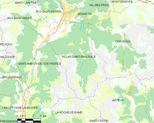
Saint-Martin-de-Queyrières (Saint-Martin-de-Queyrières)
- commune in Hautes-Alpes, France
 Hiking in Saint-Martin-de-Queyrières
Saint-Martin-de-Queyrières is a charming village located in the Hautes-Alpes region of France. It's a fantastic starting point for hiking enthusiasts as it offers access to stunning landscapes, diverse trails, and beautiful views of the Écrins National Park and surrounding mountains. Here are some highlights regarding hiking in this area:
Trails and Routes
-
GR54: Tour des Écrins - This long-distance trail encircles the Écrins Massif and is popular among experienced hikers. It features breathtaking mountain scenery and various challenging sections.
-
Local Trails - There are numerous shorter trails around Saint-Martin-de-Queyrières that cater to different levels of hikers. Many trails lead through forested areas, meadows, and offer panoramic views of the surrounding peaks.
-
Lac de la Combette - A scenic hike that takes you to a beautiful mountain lake, perfect for a picnic or just to enjoy the tranquility of nature.
-
Access to the Vallée de la Clarée - This beautiful valley is accessible from the village and holds numerous hiking opportunities with stunning landscapes, allowing you to explore waterfalls and alpine flora.
Preparation
-
Suitable Gear: Ensure you have proper hiking boots, weather-appropriate clothing, and a good backpack with essentials (water, snacks, first aid kit).
-
Maps and Navigation: Consider bringing a physical map or a GPS device, as trails might not always be well-marked.
-
Weather Conditions: Check the weather forecast before heading out, as Alpine weather can change rapidly.
Safety
-
Check Trail Conditions: Some higher altitude trails may be subject to snow or ice depending on the season. Always check local conditions.
-
Hydration and Nutrition: Carry sufficient water and snacks to keep your energy up during your hikes.
-
Wildlife Awareness: Be mindful of local wildlife and respect their habitats.
Scenic Highlights
- The proximity to the Alps means breathtaking views, picturesque landscapes, and opportunities to photograph unique flora and fauna.
- The area is also rich in cultural heritage, so you might discover historical sites and traditional alpine chalets along the trails.
Local Amenities
Saint-Martin-de-Queyrières has local accommodations, restaurants, and shops for hikers. After a day on the trails, it’s a nice place to relax and enjoy local cuisine.
By planning ahead and choosing trails that suit your skill level, hiking in Saint-Martin-de-Queyrières can provide an unforgettable outdoor experience amidst some of France's most beautiful mountain scenery. Enjoy your hiking adventures!
- Country:

- Postal Code: 05120
- Coordinates: 44° 50' 25" N, 6° 35' 7" E


- GPS tracks (wikiloc): [Link]
- AboveSeaLevel: 1200 м m
- Area: 55.52 sq km
- Population: 1131
- Wikipedia en: wiki(en)
- Wikipedia: wiki(fr)
- Wikidata storage: Wikidata: Q1089751
- Wikipedia Commons Category: [Link]
- Freebase ID: [/m/03mfn_k]
- Freebase ID: [/m/03mfn_k]
- GeoNames ID: Alt: [2978362]
- GeoNames ID: Alt: [2978362]
- SIREN number: [210501516]
- SIREN number: [210501516]
- INSEE municipality code: 05151
- INSEE municipality code: 05151
Shares border with regions:

Les Vigneaux
- commune in Hautes-Alpes, France
Hiking in Les Vigneaux
Les Vigneaux is a charming village located in the stunning Ecrins National Park in the French Alps. It is an excellent destination for hiking enthusiasts, featuring a variety of trails that cater to different skill levels. Here are some highlights about hiking in and around Les Vigneaux:...
- Country:
- Postal Code: 05120
- Coordinates: 44° 49' 26" N, 6° 32' 27" E
- GPS tracks (wikiloc): [Link]
- Area: 15.99 sq km
- Population: 521

Vallouise
- former commune in Hautes-Alpes, France
Hiking in Vallouise
Vallouise, located in the French Alps within the Ecrins National Park, is a stunning destination for hiking enthusiasts. The area is renowned for its breathtaking mountain landscapes, diverse ecosystems, and a variety of trails suitable for all levels of hikers....
- Country:
- Postal Code: 05290
- Coordinates: 44° 50' 42" N, 6° 29' 13" E
- GPS tracks (wikiloc): [Link]
- Area: 68.58 sq km
- Population: 758

La Roche-de-Rame
- commune in Hautes-Alpes, France
Hiking in La Roche-de-Rame
La Roche-de-Rame is a picturesque commune located in the Hautes-Alpes department in southeastern France. It is nestled in the stunning French Alps, providing a perfect backdrop for hiking enthusiasts. Here are some key points to consider if you're planning a hiking trip to La Roche-de-Rame:...
- Country:
- Postal Code: 05310
- Coordinates: 44° 45' 0" N, 6° 34' 50" E
- GPS tracks (wikiloc): [Link]
- Area: 40.53 sq km
- Population: 837

Puy-Saint-André
- commune in Hautes-Alpes, France
Hiking in Puy-Saint-André
Puy-Saint-André is a charming village located in the Hautes-Alpes region of southeastern France, and it serves as a wonderful base for hiking enthusiasts. Nestled near the Écrins National Park, the area boasts stunning alpine scenery, diverse flora and fauna, and a range of trails suitable for various skill levels....
- Country:
- Postal Code: 05100
- Coordinates: 44° 52' 44" N, 6° 35' 55" E
- GPS tracks (wikiloc): [Link]
- Area: 15.37 sq km
- Population: 466

Pelvoux
- former commune in Hautes-Alpes, France
Hiking in Pelvoux
Pelvoux is a beautiful region located in the French Alps, specifically in the Ecrins National Park. It's known for its stunning mountain landscapes, varied hiking trails, and breathtaking views. Here are some key points to keep in mind when planning a hiking trip to Pelvoux:...
- Country:
- Postal Code: 05340
- Coordinates: 44° 52' 9" N, 6° 29' 12" E
- GPS tracks (wikiloc): [Link]
- Area: 76.23 sq km
- Population: 483

L'Argentière-la-Bessée
- commune in Hautes-Alpes, France
Hiking in L'Argentière-la-Bessée
L'Argentière-la-Bessée, located in the Hautes-Alpes region of France, is a picturesque village surrounded by stunning mountain ranges, making it a fantastic destination for hiking enthusiasts. Here are some highlights and tips for hiking in this area:...
- Country:
- Postal Code: 05120
- Coordinates: 44° 47' 40" N, 6° 33' 33" E
- GPS tracks (wikiloc): [Link]
- Area: 64.55 sq km
- Population: 2307

Villar-Saint-Pancrace
- commune in Hautes-Alpes, France
Hiking in Villar-Saint-Pancrace
Villar-Saint-Pancrace is a charming alpine village located in the Provence-Alpes-Côte d'Azur region of France, near the town of Briançon. The area is known for its stunning landscapes, rich biodiversity, and a variety of hiking trails that cater to different skill levels. Here are some highlights for hiking in this region:...
- Country:
- Postal Code: 05100
- Coordinates: 44° 52' 23" N, 6° 37' 38" E
- GPS tracks (wikiloc): [Link]
- AboveSeaLevel: 1260 м m
- Area: 42.53 sq km
- Population: 1457