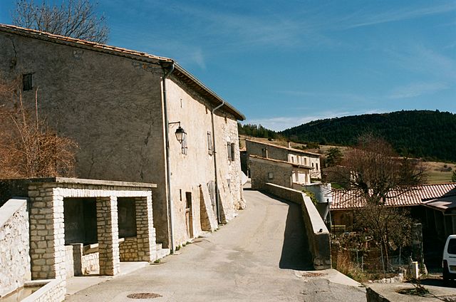
Pennes-le-Sec (Pennes-le-Sec)

- commune in Drôme, France
 Hiking in Pennes-le-Sec
Pennes-le-Sec, located in the southern French region of Provence, offers a unique and scenic environment for hiking enthusiasts. The area is characterized by its charming landscapes, diverse flora and fauna, and views of the surrounding mountains and valleys.
Hiking Trails
-
Les Collines de Pennes-le-Sec: This area has several well-marked trails that are suitable for varying skill levels. These trails allow hikers to explore rolling hills, vineyards, and woodlands.
-
Sentier des Crêtes: A popular route that offers panoramic views of the landscape. The trail is often accessorized with informative signs about the area's natural history.
-
Circuit des Sources: This trail takes you through areas where local springs and streams can be found, providing a refreshing backdrop and opportunities to observe local wildlife.
Best Time to Hike
The ideal time for hiking in Pennes-le-Sec is typically spring (April to June) and fall (September to October), when temperatures are mild, and the scenery is vibrant. Summer can be hot, which might make hiking more challenging.
Preparation Tips
- Footwear: Be sure to wear sturdy, comfortable hiking boots for stability on uneven terrain.
- Hydration: Always carry water, as some trails may not have water sources nearby.
- Navigation: While trails are generally well-marked, carrying a map or GPS device is advisable.
- Weather: Be aware of weather conditions before heading out, as they can change rapidly in mountainous areas.
Safety Considerations
- Monitor local wildlife and be respectful of their habitat.
- Inform someone of your hiking plans and expected return time.
- If hiking alone, consider sticking to well-traveled paths.
Pennes-le-Sec is a beautiful location that combines the charm of Provence with the adventure of hiking, making it an excellent destination for outdoor enthusiasts.
- Country:

- Postal Code: 26340
- Coordinates: 44° 38' 17" N, 5° 19' 6" E


- GPS tracks (wikiloc): [Link]
- Area: 9.31 sq km
- Population: 31
- Wikipedia en: wiki(en)
- Wikipedia: wiki(fr)
- Wikidata storage: Wikidata: Q1009432
- Wikipedia Commons Category: [Link]
- Freebase ID: [/m/03mgkq9]
- GeoNames ID: Alt: [6614781]
- SIREN number: [212602288]
- BnF ID: [15253089j]
- INSEE municipality code: 26228
Shares border with regions:


Barnave
- commune in Drôme, France
Hiking in Barnave
Barnave is a small village located in the Drôme department in the Auvergne-Rhône-Alpes region of southeastern France. The area is known for its stunning natural landscapes, making it an excellent destination for hiking enthusiasts. Here are some highlights about hiking in and around Barnave:...
- Country:
- Postal Code: 26310
- Coordinates: 44° 39' 36" N, 5° 22' 12" E
- GPS tracks (wikiloc): [Link]
- Area: 13.06 sq km
- Population: 185
Pradelle
- commune in Drôme, France
Hiking in Pradelle
Pradelle, located in the Drôme department in southeastern France, offers a delightful setting for hiking enthusiasts. Nestled in the beautiful landscape of the Drôme Provençale region, it boasts picturesque views, rolling hills, and diverse flora and fauna....
- Country:
- Postal Code: 26340
- Coordinates: 44° 36' 29" N, 5° 17' 31" E
- GPS tracks (wikiloc): [Link]
- Area: 12.92 sq km
- Population: 19

Rimon-et-Savel
- commune in Drôme, France
Hiking in Rimon-et-Savel
Rimon-et-Savel is a beautiful commune located in the Drôme department in the Auvergne-Rhône-Alpes region of southeastern France. It's known for its picturesque landscapes and outdoor activities, making it a great destination for hiking enthusiasts....
- Country:
- Postal Code: 26340
- Coordinates: 44° 39' 48" N, 5° 18' 27" E
- GPS tracks (wikiloc): [Link]
- Area: 12.31 sq km
- Population: 29


Aucelon
- commune in Drôme, France
Hiking in Aucelon
Aucelon is a small village located in the Ardèche region of France, known for its stunning natural beauty and diverse hiking opportunities. Here’s an overview of what to expect when hiking in Aucelon:...
- Country:
- Postal Code: 26340
- Coordinates: 44° 37' 27" N, 5° 20' 40" E
- GPS tracks (wikiloc): [Link]
- Area: 26.34 sq km
- Population: 14