Peynier (Peynier)

- commune in Bouches-du-Rhône, France
 Hiking in Peynier
Peynier is a charming village located in the Provence-Alpes-Côte d'Azur region of France. It's surrounded by beautiful landscapes, making it an excellent spot for hiking enthusiasts. Here are some highlights and tips for hiking in and around Peynier:
Scenic Trails
-
Sainte-Victoire Mountain: Just a short drive from Peynier, the iconic Montagne Sainte-Victoire offers several well-marked trails. The most popular routes provide stunning views of the peak and surrounding vineyards.
-
Regional Natural Park of Sainte-Baume: This nearby park features a variety of hiking trails that wind through lush forests, limestone cliffs, and quaint villages. The diverse terrain offers something for every skill level.
-
Luberon Regional Park: A little further afield, the Luberon area is known for its picturesque villages and lavender fields. Numerous trails are available that showcase the natural beauty and culture of the region.
Hiking Tips
-
Weather: The climate in Provence can be hot in the summer, so it's best to hike in the early morning or late afternoon. Spring and fall offer more moderate temperatures.
-
Footwear: Good hiking boots are essential, as trails can vary from easy walks to more challenging terrain.
-
Water and Snacks: Always carry plenty of water and some snacks, especially on longer hikes, as some trails may not have nearby facilities.
-
Map and Navigation: While many trails are clearly marked, having a map or a GPS app can be helpful, particularly in less traveled areas.
-
Respect Nature: Follow the Leave No Trace principles to keep the natural environment pristine for future hikers.
Local Attractions
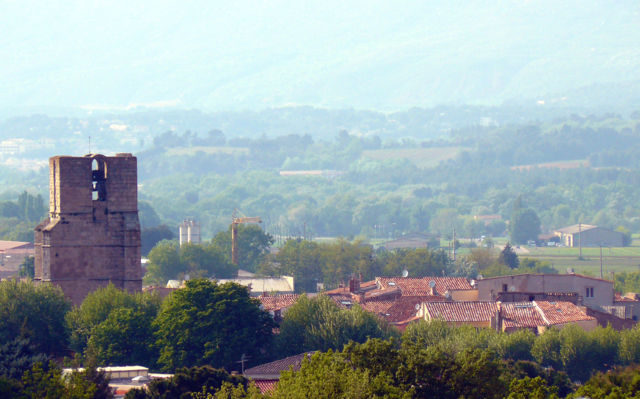
- After your hike, consider exploring the village of Peynier itself. It's known for its beautiful architecture, local markets, and traditional Provençal cuisine.
Overall, Peynier serves as a wonderful base for exploring the stunning southern French landscape, with a variety of hiking options to suit all levels of experience. Enjoy your outdoor adventure!
- Country:

- Postal Code: 13790
- Coordinates: 43° 26' 49" N, 5° 38' 29" E


- GPS tracks (wikiloc): [Link]
- Area: 24.76 sq km
- Population: 3368
- Web site: http://www.peynier.free.fr
- Wikipedia en: wiki(en)
- Wikipedia: wiki(fr)
- Wikidata storage: Wikidata: Q594551
- Wikipedia Commons Category: [Link]
- Freebase ID: [/m/02rpcny]
- GeoNames ID: Alt: [2987551]
- SIREN number: [211300728]
- BnF ID: [15247354g]
- WOEID: [616351]
- INSEE municipality code: 13072
Shares border with regions:

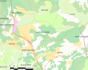
La Bouilladisse
- commune in Bouches-du-Rhône, France
Hiking in La Bouilladisse
La Bouilladisse is a charming commune located in the Bouches-du-Rhône department in southeastern France, nestled in the picturesque region of Provence. It offers a variety of hiking opportunities, characterized by beautiful landscapes, scenic views, and a mild Mediterranean climate....
- Country:
- Postal Code: 13720
- Coordinates: 43° 23' 43" N, 5° 35' 43" E
- GPS tracks (wikiloc): [Link]
- Area: 12.61 sq km
- Population: 6079
- Web site: [Link]


Belcodène
- commune in Bouches-du-Rhône, France
Hiking in Belcodène
Belcodène is a charming commune located in the Bouches-du-Rhône department in southern France, near the Sainte-Baume mountain range. The natural scenery around Belcodène offers a wonderful setting for hiking enthusiasts, combining picturesque landscapes with diverse flora and fauna....
- Country:
- Postal Code: 13720
- Coordinates: 43° 25' 35" N, 5° 35' 21" E
- GPS tracks (wikiloc): [Link]
- Area: 12.97 sq km
- Population: 1906
- Web site: [Link]

Trets
- commune in Bouches-du-Rhône, France
Hiking in Trets
Trets is a charming town located in the Provence-Alpes-Côte d'Azur region of France, and it offers access to some beautiful hiking opportunities. The surrounding landscape features rolling hills, vineyards, and stunning views of the Sainte-Victoire Mountain, making it an appealing destination for outdoor enthusiasts....
- Country:
- Postal Code: 13530
- Coordinates: 43° 26' 49" N, 5° 41' 9" E
- GPS tracks (wikiloc): [Link]
- Area: 70.31 sq km
- Population: 10963
- Web site: [Link]

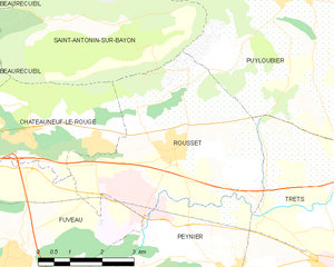
Rousset
- commune in Bouches-du-Rhône, France
Hiking in Rousset
Rousset, located in the Bouches-du-Rhône department of southern France, is a beautiful area that offers a variety of hiking opportunities, thanks to its stunning landscapes and proximity to the Sainte-Victoire Mountain. Here are some highlights for hiking in Rousset:...
- Country:
- Postal Code: 13790
- Coordinates: 43° 28' 56" N, 5° 37' 20" E
- GPS tracks (wikiloc): [Link]
- AboveSeaLevel: 224 м m
- Area: 19.5 sq km
- Population: 4768
- Web site: [Link]


Fuveau
- commune in Bouches-du-Rhône, France
Hiking in Fuveau
Fuveau is a charming commune located in the Bouches-du-Rhône department of the Provence-Alpes-Côte d'Azur region in southeastern France. It's surrounded by beautiful landscapes that offer a variety of hiking opportunities....
- Country:
- Postal Code: 13710
- Coordinates: 43° 27' 8" N, 5° 33' 42" E
- GPS tracks (wikiloc): [Link]
- Area: 30.02 sq km
- Population: 9756
- Web site: [Link]