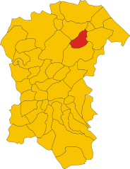
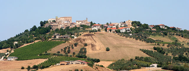
Pianella (Pianella)
.svg)
- Italian comune
 Hiking in Pianella
Pianella, located in the province of Pescara in Italy, is surrounded by beautiful landscapes and offers several hiking opportunities. The region is characterized by its rolling hills, vineyards, and stunning views of the Adriatic Sea and the Apennine Mountains. Here are some considerations and recommendations for hiking in the area:
Trails and Areas to Explore:
-
Gran Sasso and Monti della Laga National Park: This nearby national park is easily accessible and offers diverse hiking trails, ranging from easy walks to challenging treks. The park is home to rugged mountain terrains, diverse flora and fauna, and breathtaking views.
-
Vallone delle Centenari: This trail provides a moderate hike with picturesque scenery. You can enjoy the tranquility of nature, river views, and possibly catch a glimpse of local wildlife.
-
Pianella to Civitella Casanova: A lovely trail that takes you through vineyards and olive groves, offering a taste of the local culture and landscape. The hike rewards you with lovely panoramic views of the surrounding hills.
-
Colle di Pretara: Known for its stunning landscapes, this area offers several trails that vary in difficulty and are suitable for everyone, from beginners to experienced hikers.
Tips for Hiking in Pianella:
-
Best Time to Hike: The best season for hiking in this area is typically from spring to early autumn (April to October), when the weather is mild and the landscape is lush and vibrant.
-
Hydration and Snacks: Always carry enough water and some snacks. The hikes can be long, and having sustenance will keep your energy levels up.
-
Proper Footwear: Invest in good quality hiking boots or shoes to provide you with support and stability on varying terrains.
-
Navigation: While many trails are marked, a good map or GPS navigation can be helpful, especially for less-trafficked paths.
-
Respect Nature: Follow Leave No Trace principles. Stay on marked trails, take all your trash with you, and be mindful of the local wildlife.
-
Check Local Maps and Guides: Before heading out, check local resources or visitor centers for updated trail information, as conditions may change.
Hiking in Pianella can be a rewarding experience, combining the beauty of nature with the charm of Italian culture. Enjoy your adventure!
- Country:

- Postal Code: 65019
- Local Dialing Code: 085
- Licence Plate Code: PE
- Coordinates: 42° 23' 57" N, 14° 2' 52" E


- GPS tracks (wikiloc): [Link]
- AboveSeaLevel: 236 м m
- Area: 47.05 sq km
- Population: 8652
- Web site: http://www.comune.pianella.pe.it/
- Wikipedia en: wiki(en)
- Wikipedia: wiki(it)
- Wikidata storage: Wikidata: Q51378
- Wikipedia Commons Category: [Link]
- Freebase ID: [/m/0fg8sk]
- GeoNames ID: Alt: [6540729]
- VIAF ID: Alt: [144677871]
- OSM relation ID: [41985]
- UN/LOCODE: [ITPIN]
- ISTAT ID: 068030
- Italian cadastre code: G555
Shares border with regions:


Catignano
- Italian comune
Hiking in Catignano
Catignano is a charming town in the Abruzzo region of Italy, surrounded by beautiful landscapes and offering various hiking opportunities. When hiking in and around Catignano, you're likely to encounter a blend of natural beauty, historical sites, and local culture. Here are some highlights and tips for hiking in the area:...
- Country:
- Postal Code: 65011
- Local Dialing Code: 085
- Licence Plate Code: PE
- Coordinates: 42° 20' 49" N, 13° 57' 7" E
- GPS tracks (wikiloc): [Link]
- AboveSeaLevel: 365 м m
- Area: 17.03 sq km
- Population: 1337
- Web site: [Link]
Cepagatti
- Italian comune
Hiking in Cepagatti
Cepagatti is a charming town located in the Abruzzo region of Italy, known for its picturesque landscapes and proximity to the Apennine Mountains. While it's not as famous as some other hiking destinations, it does offer opportunities for outdoor enthusiasts to explore the beautiful surrounding countryside. Here are some points to consider for hiking in and around Cepagatti:...
- Country:
- Postal Code: 65012
- Local Dialing Code: 085
- Licence Plate Code: PE
- Coordinates: 42° 21' 57" N, 14° 4' 36" E
- GPS tracks (wikiloc): [Link]
- AboveSeaLevel: 145 м m
- Area: 30.82 sq km
- Population: 11014
- Web site: [Link]


Loreto Aprutino
- Italian comune
Hiking in Loreto Aprutino
Loreto Aprutino is a charming town located in the Abruzzo region of Italy, known for its stunning landscapes, rolling hills, and proximity to both the mountains and the Adriatic coast. This area offers a variety of hiking opportunities suitable for different skill levels, all set against a backdrop of beautiful natural scenery and historical sites....
- Country:
- Postal Code: 65014
- Local Dialing Code: 085
- Licence Plate Code: PE
- Coordinates: 42° 26' 5" N, 13° 59' 1" E
- GPS tracks (wikiloc): [Link]
- AboveSeaLevel: 307 м m
- Area: 59.5 sq km
- Population: 7369
- Web site: [Link]

Moscufo
- Italian comune
Hiking in Moscufo
Moscufo is a picturesque village located in the Abruzzo region of Italy, near Pescara. While not as well-known for hiking as some other areas in Italy, it is surrounded by scenic landscapes, rolling hills, and natural beauty that can offer some interesting walking and hiking opportunities. Here are some aspects to consider if you’re planning to hike in or near Moscufo:...
- Country:
- Postal Code: 65010
- Local Dialing Code: 085
- Licence Plate Code: PE
- Coordinates: 42° 26' 0" N, 14° 3' 0" E
- GPS tracks (wikiloc): [Link]
- AboveSeaLevel: 246 м m
- Area: 20.26 sq km
- Population: 3168
- Web site: [Link]

Nocciano
- Italian comune
Hiking in Nocciano
Nocciano, a charming town in the Abruzzo region of Italy, offers a variety of opportunities for hiking enthusiasts. The surrounding countryside is characterized by rolling hills, vineyards, and scenic views of the Majella and Gran Sasso mountain ranges, making it an excellent destination for outdoor activities....
- Country:
- Postal Code: 65010
- Local Dialing Code: 085
- Licence Plate Code: PE
- Coordinates: 42° 20' 0" N, 13° 59' 0" E
- GPS tracks (wikiloc): [Link]
- AboveSeaLevel: 301 м m
- Area: 13.76 sq km
- Population: 1796
- Web site: [Link]


Rosciano
- Italian comune
Hiking in Rosciano
Rosciano, located in the Abruzzo region of Italy, is a fantastic destination for hiking, thanks to its picturesque landscapes, rolling hills, and proximity to both mountains and coastal areas. Here are some highlights and tips for hiking in and around Rosciano:...
- Country:
- Postal Code: 65020
- Local Dialing Code: 085
- Licence Plate Code: PE
- Coordinates: 42° 19' 20" N, 14° 2' 44" E
- GPS tracks (wikiloc): [Link]
- AboveSeaLevel: 253 м m
- Area: 27.79 sq km
- Population: 3949
- Web site: [Link]


Spoltore
- Italian comune
Hiking in Spoltore
Spoltore, located in the Abruzzo region of Italy, is a charming town that offers scenic hiking opportunities thanks to its proximity to both the mountains and the Adriatic coast. While it may not be as widely known as some other hiking destinations, the surrounding area provides a variety of trails suitable for different skill levels. Here are some highlights for hiking around Spoltore:...
- Country:
- Postal Code: 65010
- Local Dialing Code: 085
- Licence Plate Code: PE
- Coordinates: 42° 27' 18" N, 14° 8' 24" E
- GPS tracks (wikiloc): [Link]
- AboveSeaLevel: 185 м m
- Area: 37.01 sq km
- Population: 19378
- Web site: [Link]