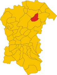
Loreto Aprutino (Loreto Aprutino)
.svg)
- Italian comune
 Hiking in Loreto Aprutino
Loreto Aprutino is a charming town located in the Abruzzo region of Italy, known for its stunning landscapes, rolling hills, and proximity to both the mountains and the Adriatic coast. This area offers a variety of hiking opportunities suitable for different skill levels, all set against a backdrop of beautiful natural scenery and historical sites.
Hiking Trails
-
Monte Maiella:
- A bit further from Loreto Aprutino, but easily accessible, this mountain offers breathtaking views and a chance to explore diverse flora and fauna. Trails vary from easy to challenging.
-
Gran Sasso e Monti della Laga National Park:
- This is a bit further afield, but it's worth visiting for its spectacular scenery. You'll find numerous trails that take you through rugged landscapes, alpine meadows, and past crystal-clear rivers.
-
Local Countryside Paths:
- There are many well-marked trails that wind through the vineyards, olive groves, and countryside surrounding Loreto Aprutino. These paths are generally easier and perfect for leisurely strolls while soaking in the rural charm and local culture.
-
Castello di Loreto:
- A hike to the medieval castle offers a relatively short but rewarding trek. The views from the top are impressive and give you a glimpse of the surrounding region.
Tips for Hiking in Loreto Aprutino
- Best Time to Hike: Spring (April to June) and fall (September to October) are ideal for hiking, thanks to mild temperatures and blooming landscapes.
- Footwear: Wear good hiking boots with solid grip and consider bringing trekking poles for slippery paths.
- Stay Hydrated: Carry enough water, especially on longer hikes, and bring snacks to keep your energy up.
- Maps and Guides: While many paths are marked, having a map or a hiking app can enhance your experience. Consider hiring a local guide if you want to dive deeper into the area's history and ecology.
- Respect Nature: Make sure to follow Leave No Trace principles to help protect the area.
Culture & Attractions
After a day of hiking, take the time to explore Loreto Aprutino’s historical sites, such as:
- Church of Santa Maria in Piano: Known for its beautiful artwork.
- Palazzo De Felice: A stunning example of local architecture.
Enjoying both nature and culture can make your hiking trip to Loreto Aprutino a truly memorable experience!
- Country:

- Postal Code: 65014
- Local Dialing Code: 085
- Licence Plate Code: PE
- Coordinates: 42° 26' 5" N, 13° 59' 1" E


- GPS tracks (wikiloc): [Link]
- AboveSeaLevel: 307 м m
- Area: 59.5 sq km
- Population: 7369
- Web site: http://www.comune.loretoaprutino.pe.it/
- Wikipedia en: wiki(en)
- Wikipedia: wiki(it)
- Wikidata storage: Wikidata: Q51369
- Wikipedia Commons Category: [Link]
- Freebase ID: [/m/0fg8pt]
- GeoNames ID: Alt: [6537469]
- VIAF ID: Alt: [143391734]
- OSM relation ID: [41990]
- WOEID: [717427]
- UN/LOCODE: [ITLA7]
- DMOZ ID: Alt: [Regional/Europe/Italy/Abruzzo/Localities/Loreto_Aprutino/]
- ISTAT ID: 068021
- Italian cadastre code: E691
Shares border with regions:


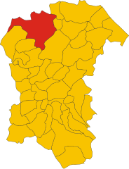
Catignano
- Italian comune
Hiking in Catignano
Catignano is a charming town in the Abruzzo region of Italy, surrounded by beautiful landscapes and offering various hiking opportunities. When hiking in and around Catignano, you're likely to encounter a blend of natural beauty, historical sites, and local culture. Here are some highlights and tips for hiking in the area:...
- Country:
- Postal Code: 65011
- Local Dialing Code: 085
- Licence Plate Code: PE
- Coordinates: 42° 20' 49" N, 13° 57' 7" E
- GPS tracks (wikiloc): [Link]
- AboveSeaLevel: 365 м m
- Area: 17.03 sq km
- Population: 1337
- Web site: [Link]
Civitaquana
- Italian comune
Hiking in Civitaquana
Civitaquana, located in the Abruzzo region of Italy, offers an array of hiking opportunities for outdoor enthusiasts. Nestled in the Apennine Mountains, this charming village is surrounded by scenic landscapes, making it a fantastic destination for nature lovers. Here are some aspects to consider when hiking in Civitaquana:...
- Country:
- Postal Code: 65010
- Local Dialing Code: 085
- Licence Plate Code: PE
- Coordinates: 42° 20' 0" N, 13° 54' 0" E
- GPS tracks (wikiloc): [Link]
- AboveSeaLevel: 550 м m
- Area: 21.88 sq km
- Population: 1225
- Web site: [Link]


Civitella Casanova
- Italian comune
Hiking in Civitella Casanova
Civitella Casanova is a picturesque village in the Abruzzo region of Italy, known for its natural beauty, historical architecture, and stunning landscapes. Hiking in this area offers an opportunity to explore the scenic countryside, enjoy panoramic views, and experience the rich flora and fauna of the region....
- Country:
- Postal Code: 65010
- Local Dialing Code: 085
- Licence Plate Code: PE
- Coordinates: 42° 22' 0" N, 13° 53' 0" E
- GPS tracks (wikiloc): [Link]
- AboveSeaLevel: 400 м m
- Area: 31.1 sq km
- Population: 1759
- Web site: [Link]
Collecorvino
- Italian comune
Hiking in Collecorvino
Collecorvino is a charming town located in the Abruzzo region of Italy, known for its scenic landscapes and outdoor activities, including hiking. The area surrounding Collecorvino offers beautiful trails that vary in difficulty, making it suitable for both beginner and experienced hikers....
- Country:
- Postal Code: 65010
- Local Dialing Code: 085
- Licence Plate Code: PE
- Coordinates: 42° 28' 0" N, 14° 1' 0" E
- GPS tracks (wikiloc): [Link]
- AboveSeaLevel: 254 м m
- Area: 31.99 sq km
- Population: 6060
- Web site: [Link]

Moscufo
- Italian comune
Hiking in Moscufo
Moscufo is a picturesque village located in the Abruzzo region of Italy, near Pescara. While not as well-known for hiking as some other areas in Italy, it is surrounded by scenic landscapes, rolling hills, and natural beauty that can offer some interesting walking and hiking opportunities. Here are some aspects to consider if you’re planning to hike in or near Moscufo:...
- Country:
- Postal Code: 65010
- Local Dialing Code: 085
- Licence Plate Code: PE
- Coordinates: 42° 26' 0" N, 14° 3' 0" E
- GPS tracks (wikiloc): [Link]
- AboveSeaLevel: 246 м m
- Area: 20.26 sq km
- Population: 3168
- Web site: [Link]

Penne, Abruzzo
- Italian comune
Hiking in Penne, Abruzzo
Hiking in Penne, a charming town in the Abruzzo region of Italy, offers you a rich blend of natural beauty, historical significance, and cultural experiences. Here are some highlights and tips for hiking in this picturesque area:...
- Country:
- Postal Code: 65017
- Local Dialing Code: 085
- Licence Plate Code: PE
- Coordinates: 42° 27' 0" N, 13° 55' 0" E
- GPS tracks (wikiloc): [Link]
- AboveSeaLevel: 438 м m
- Area: 91.2 sq km
- Population: 12113
- Web site: [Link]


Pianella
- Italian comune
Hiking in Pianella
Pianella, located in the province of Pescara in Italy, is surrounded by beautiful landscapes and offers several hiking opportunities. The region is characterized by its rolling hills, vineyards, and stunning views of the Adriatic Sea and the Apennine Mountains. Here are some considerations and recommendations for hiking in the area:...
- Country:
- Postal Code: 65019
- Local Dialing Code: 085
- Licence Plate Code: PE
- Coordinates: 42° 23' 57" N, 14° 2' 52" E
- GPS tracks (wikiloc): [Link]
- AboveSeaLevel: 236 м m
- Area: 47.05 sq km
- Population: 8652
- Web site: [Link]


Picciano
- Italian comune
Hiking in Picciano
Picciano, a charming village located in the Abruzzo region of Italy, offers a unique hiking experience amidst its stunning landscapes and rich historical context. Here are some key points to consider if you’re planning a hiking trip in Picciano:...
- Country:
- Postal Code: 65010
- Local Dialing Code: 085
- Licence Plate Code: PE
- Coordinates: 42° 28' 31" N, 13° 59' 24" E
- GPS tracks (wikiloc): [Link]
- AboveSeaLevel: 153 м m
- Area: 7.56 sq km
- Population: 1346
- Web site: [Link]