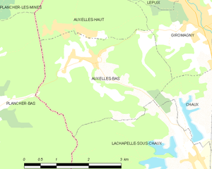
Plancher-Bas (Plancher-Bas)

- commune in Haute-Saône, France
- Country:

- Postal Code: 70290
- Coordinates: 47° 43' 16" N, 6° 43' 58" E


- GPS tracks (wikiloc): [Link]
- Area: 29.12 sq km
- Population: 1963
- Web site: http://www.mairie-plancher-bas.fr
- Wikipedia en: wiki(en)
- Wikipedia: wiki(fr)
- Wikidata storage: Wikidata: Q768551
- Wikipedia Commons Category: [Link]
- Freebase ID: [/m/03nv1_v]
- GeoNames ID: Alt: [6442064]
- SIREN number: [217004134]
- BnF ID: [152728052]
- WOEID: [12650655]
- INSEE municipality code: 70413
Shares border with regions:

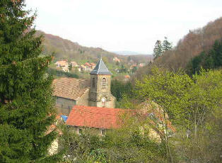
Auxelles-Bas
- commune in Territoire de Belfort, France
- Country:
- Postal Code: 90200
- Coordinates: 47° 44' 3" N, 6° 46' 50" E
- GPS tracks (wikiloc): [Link]
- Area: 9.41 sq km
- Population: 474
- Web site: [Link]

Auxelles-Haut
- commune in Territoire de Belfort, France
- Country:
- Postal Code: 90200
- Coordinates: 47° 44' 36" N, 6° 46' 23" E
- GPS tracks (wikiloc): [Link]
- Area: 6.48 sq km
- Population: 294


Plancher-les-Mines
- commune in Haute-Saône, France
- Country:
- Postal Code: 70290
- Coordinates: 47° 45' 39" N, 6° 44' 33" E
- GPS tracks (wikiloc): [Link]
- Area: 25.59 sq km
- Population: 1006
- Web site: [Link]

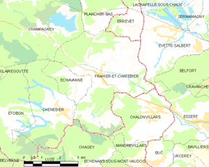
Frahier-et-Chatebier
- commune in Haute-Saône, France
- Country:
- Postal Code: 70400
- Coordinates: 47° 39' 37" N, 6° 44' 51" E
- GPS tracks (wikiloc): [Link]
- Area: 17.39 sq km
- Population: 1360
- Web site: [Link]


Champagney
- commune in Haute-Saône, France
- Country:
- Postal Code: 70290
- Coordinates: 47° 42' 21" N, 6° 40' 56" E
- GPS tracks (wikiloc): [Link]
- AboveSeaLevel: 388 м m
- Area: 36.71 sq km
- Population: 3811
- Web site: [Link]


Errevet
- commune in Haute-Saône, France
- Country:
- Postal Code: 70400
- Coordinates: 47° 41' 6" N, 6° 46' 33" E
- GPS tracks (wikiloc): [Link]
- Area: 3.28 sq km
- Population: 251
- Web site: [Link]


Lachapelle-sous-Chaux
- commune in Territoire de Belfort, France
- Country:
- Postal Code: 90300
- Coordinates: 47° 42' 17" N, 6° 49' 16" E
- GPS tracks (wikiloc): [Link]
- Area: 11.16 sq km
- Population: 718
- Web site: [Link]
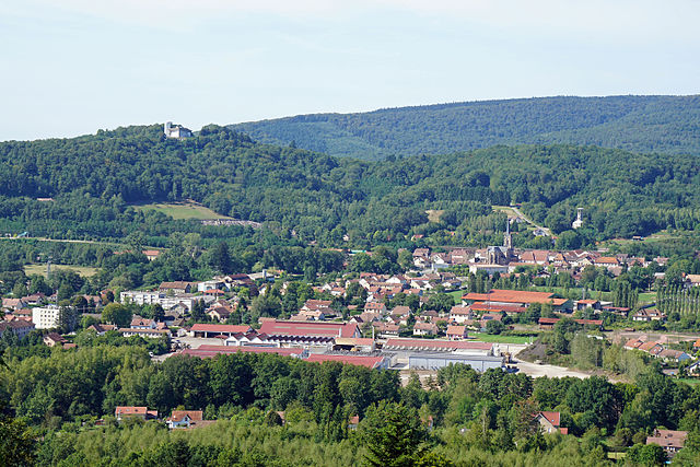

Ronchamp
- commune in Haute-Saône, France
- Country:
- Postal Code: 70250
- Coordinates: 47° 42' 1" N, 6° 38' 0" E
- GPS tracks (wikiloc): [Link]
- AboveSeaLevel: 353 м m
- Area: 23.54 sq km
- Population: 2807
- Web site: [Link]


Fresse
- commune in Haute-Saône, France
- Country:
- Postal Code: 70270
- Coordinates: 47° 45' 27" N, 6° 39' 26" E
- GPS tracks (wikiloc): [Link]
- Area: 27.15 sq km
- Population: 744
- Web site: [Link]