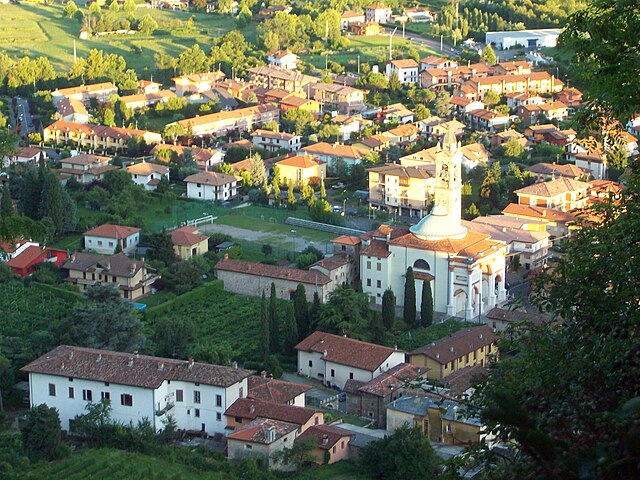
Pradalunga (Pradalunga)
.svg)

- Italian comune
 Hiking in Pradalunga
Pradalunga, located in the Lombardy region of Italy, offers a beautiful area for hiking enthusiasts. Nestled in the hills near Bergamo, it features a mix of scenic landscapes, charming villages, and lush nature. Here’s what you can expect when hiking in this area:
Trail Variety
-
Scenic Trails: The region provides a range of trails that lead through forests, hills, and fields, offering breathtaking views of the surrounding landscapes, including the nearby Orobie Mountains.
-
Difficulty Levels: Trails range from easy walks suitable for families to more challenging hikes for experienced trekkers. Be sure to choose a trail that fits your skill level.
-
Marked Routes: Many trails are well-marked, making navigation easier. However, it’s always a good idea to bring a trail map or a GPS device.
Natural Attractions
-
Flora and Fauna: Enjoy the rich biodiversity, with various species of plants and wildlife. You might encounter local flora, including wildflowers and trees, as well as birds and other wildlife.
-
Panoramic Views: Several viewpoints along the trails provide stunning vistas of the surrounding mountains and valleys, especially at sunrise or sunset.
Cultural Aspects
- Historical Sights: Some trails may lead you to historical landmarks, including old churches and ruins, giving you a glimpse into the region’s history and culture.
Practical Information
-
Best Season: Spring and early autumn are ideal for hiking, as temperatures are moderate, and the landscape is lush.
-
Local Resources: Check for local tourism services in Pradalunga for maps, guided tours, and helpful information about weather conditions.
-
Safety: Keep in mind to bring adequate supplies, such as water, snacks, a first-aid kit, and proper footwear. Always let someone know your hiking plans and expected return time.
Conclusion
Hiking in Pradalunga offers a unique blend of natural beauty and cultural experiences. Whether you are looking for a leisurely walk or a more strenuous hike, you’ll find a variety of options to enjoy this lovely region in Italy. Happy hiking!
- Country:

- Postal Code: 24020
- Local Dialing Code: 035
- Licence Plate Code: BG
- Coordinates: 45° 44' 48" N, 9° 46' 59" E


- GPS tracks (wikiloc): [Link]
- AboveSeaLevel: 327 м m
- Area: 8.2 sq km
- Population: 4674
- Web site: http://www.comunepradalunga.it/
- Wikipedia en: wiki(en)
- Wikipedia: wiki(it)
- Wikidata storage: Wikidata: Q101470
- Wikipedia Commons Gallery: [Link]
- Wikipedia Commons Category: [Link]
- Freebase ID: [/m/0gjd00]
- GeoNames ID: Alt: [6543756]
- OSM relation ID: [45915]
- MusicBrainz area ID: [a628cffb-d899-4945-b816-791c501bf626]
- UN/LOCODE: [ITPLA]
- ISTAT ID: 016173
- Italian cadastre code: G968
Shares border with regions:


Cenate Sopra
- Italian comune
Hiking in Cenate Sopra
Cenate Sopra is a picturesque town located in the province of Bergamo in Lombardy, Italy. It sits at the foothills of the Pre-Alps, making it an attractive base for hikers and nature enthusiasts. The area offers a variety of trails that cater to different skill levels, from leisurely walks to more challenging treks....
- Country:
- Postal Code: 24060
- Local Dialing Code: 035
- Licence Plate Code: BG
- Coordinates: 45° 42' 42" N, 9° 49' 20" E
- GPS tracks (wikiloc): [Link]
- AboveSeaLevel: 330 м m
- Area: 6.97 sq km
- Population: 2571
- Web site: [Link]


Nembro
- Italian comune
Hiking in Nembro
Nembro is a charming town located in the province of Bergamo, in the Lombardy region of northern Italy. It is surrounded by beautiful natural landscapes, making it a great destination for hiking enthusiasts. Here are some details about hiking in and around Nembro:...
- Country:
- Postal Code: 24027
- Local Dialing Code: 035
- Licence Plate Code: BG
- Coordinates: 45° 44' 38" N, 9° 45' 34" E
- GPS tracks (wikiloc): [Link]
- AboveSeaLevel: 309 м m
- Area: 15.24 sq km
- Population: 11530
- Web site: [Link]

Scanzorosciate
- Italian comune
Hiking in Scanzorosciate
Scanzorosciate is a charming town located in the Lombardy region of northern Italy, near the city of Bergamo. The area offers a variety of hiking opportunities that allow you to explore its stunning landscapes, nature, and cultural heritage....
- Country:
- Postal Code: 24020
- Local Dialing Code: 035
- Licence Plate Code: BG
- Coordinates: 45° 42' 41" N, 9° 44' 9" E
- GPS tracks (wikiloc): [Link]
- AboveSeaLevel: 297 м m
- Area: 10.69 sq km
- Population: 10076
- Web site: [Link]


Albino, Lombardy
- Italian comune
Hiking in Albino, Lombardy
Albino, located in the Lombardy region of Italy, is a charming town nestled in the foothills of the Bergamasque Alps. The area offers a variety of hiking opportunities, making it a great destination for outdoor enthusiasts....
- Country:
- Postal Code: 24021
- Local Dialing Code: 035
- Licence Plate Code: BG
- Coordinates: 45° 45' 38" N, 9° 47' 49" E
- GPS tracks (wikiloc): [Link]
- AboveSeaLevel: 342 м m
- Area: 31.81 sq km
- Population: 17903
- Web site: [Link]