
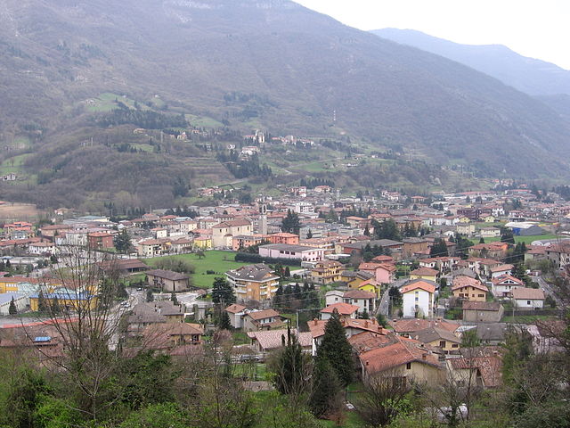
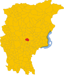
Albino, Lombardy (Albino)
.svg)
- Italian comune
 Hiking in Albino, Lombardy
Albino, located in the Lombardy region of Italy, is a charming town nestled in the foothills of the Bergamasque Alps. The area offers a variety of hiking opportunities, making it a great destination for outdoor enthusiasts.
Hiking Trails
-
Path of the Ceneri: This scenic trail offers beautiful views of the surrounding mountains and valleys. The path is well-marked and can be a good option for both beginners and experienced hikers.
-
Monte Misma: A popular destination for hikers, the trail to Monte Misma offers a moderate level of difficulty and rewards trekkers with panoramic views of the Alto Sebino and the surrounding peaks. The trailhead is easily accessible from Albino.
-
Valle dell’Inferno: This charming valley trail allows hikers to experience the natural beauty of the local flora and fauna. A hike through Valle dell’Inferno can be serene and refreshing, with opportunities to see waterfalls and rock formations.
-
Sentiero dei Fiori (Flower Trail): This route is renowned for its stunning wildflowers during the spring and early summer. It offers an easy trek that families can enjoy, with ample spots for picnicking along the way.
Tips for Hiking in Albino
- Preparation: Check the weather forecast before heading out. Some trails can become challenging when it rains or after heavy snowfall.
- Gear: Wear appropriate hiking footwear, and consider bringing trekking poles for support on uneven terrain. Always carry enough water and snacks.
- Navigation: Many trails are well-marked, but it’s good practice to have a map or GPS with you for reference.
- Local Guidance: Consider joining a guided hike or local group to learn more about the area’s ecology, history, and hidden gems.
Additional Attractions
- After your hike, explore the town of Albino, where you can find local cafes and restaurants offering delicious Lombard cuisine.
- Visit historical sites in the area, like the nearby Santa Maria Assunta church, or take a stroll through the historic center to appreciate its architecture.
Hiking in Albino can be a fulfilling experience, blending physical activity with the stunning natural beauty of the Lombardy region. Make sure to respect the local environment and leave no trace as you enjoy your adventure!
- Country:

- Postal Code: 24021
- Local Dialing Code: 035
- Licence Plate Code: BG
- Coordinates: 45° 45' 38" N, 9° 47' 49" E


- GPS tracks (wikiloc): [Link]
- AboveSeaLevel: 342 м m
- Area: 31.81 sq km
- Population: 17903
- Web site: http://www.albino.it
- Wikipedia en: wiki(en)
- Wikipedia: wiki(it)
- Wikidata storage: Wikidata: Q53489
- Wikipedia Commons Category: [Link]
- Freebase ID: [/m/04x803]
- GeoNames ID: Alt: [6540342]
- BnF ID: [13512357x]
- VIAF ID: Alt: [168079818]
- OSM relation ID: [45920]
- MusicBrainz area ID: [e5bc0445-bf6f-4229-9598-5ddf1ea12df9]
- Quora topic ID: [Albino-1]
- UN/LOCODE: [ITABN]
- Klexikon article ID: [Albino]
- ISTAT ID: 016004
- Italian cadastre code: A163
Shares border with regions:

Casazza
- Italian comune
Hiking in Casazza
Casazza is a charming town located in the Bergamo province of Italy, situated in the foothills of the Italian Alps. The area offers a variety of hiking opportunities that provide stunning views of the surrounding landscapes, including the nearby mountains and lush valleys....
- Country:
- Postal Code: 24060
- Local Dialing Code: 035
- Licence Plate Code: BG
- Coordinates: 45° 44' 55" N, 9° 54' 23" E
- GPS tracks (wikiloc): [Link]
- AboveSeaLevel: 349 м m
- Area: 7.11 sq km
- Population: 4004
- Web site: [Link]


Cenate Sopra
- Italian comune
Hiking in Cenate Sopra
Cenate Sopra is a picturesque town located in the province of Bergamo in Lombardy, Italy. It sits at the foothills of the Pre-Alps, making it an attractive base for hikers and nature enthusiasts. The area offers a variety of trails that cater to different skill levels, from leisurely walks to more challenging treks....
- Country:
- Postal Code: 24060
- Local Dialing Code: 035
- Licence Plate Code: BG
- Coordinates: 45° 42' 42" N, 9° 49' 20" E
- GPS tracks (wikiloc): [Link]
- AboveSeaLevel: 330 м m
- Area: 6.97 sq km
- Population: 2571
- Web site: [Link]


Cene
- Italian comune
Hiking in Cene
Cene is a small town located in the province of Bergamo, Lombardy, Italy. It is situated near the foothills of the Alps, which provides a beautiful setting for hiking enthusiasts. Here are some key points if you're considering hiking in and around Cene:...
- Country:
- Postal Code: 24020
- Local Dialing Code: 035
- Licence Plate Code: BG
- Coordinates: 45° 46' 46" N, 9° 49' 33" E
- GPS tracks (wikiloc): [Link]
- AboveSeaLevel: 368 м m
- Area: 8.6 sq km
- Population: 4267
- Web site: [Link]


Gaverina Terme
- Italian comune
Hiking in Gaverina Terme
Gaverina Terme, located in the province of Bergamo in Lombardy, Italy, is a charming destination known for its natural beauty, thermal springs, and outdoor activities, including hiking. Here are some key points about hiking in and around Gaverina Terme:...
- Country:
- Postal Code: 24060
- Local Dialing Code: 035
- Licence Plate Code: BG
- Coordinates: 45° 46' 0" N, 9° 53' 0" E
- GPS tracks (wikiloc): [Link]
- AboveSeaLevel: 509 м m
- Area: 5.2 sq km
- Population: 868
- Web site: [Link]


Gazzaniga
- Italian comune
Hiking in Gazzaniga
Gazzaniga, a town located in the Lombardy region of Italy, is surrounded by beautiful natural landscapes that provide fantastic opportunities for hiking enthusiasts. While the town itself may not be a well-known hiking destination, its proximity to the Orobian Alps and the Seriana Valley offers a variety of trails suitable for all levels of hikers....
- Country:
- Postal Code: 24025
- Local Dialing Code: 035
- Licence Plate Code: BG
- Coordinates: 45° 48' 0" N, 9° 50' 0" E
- GPS tracks (wikiloc): [Link]
- AboveSeaLevel: 386 м m
- Area: 14.41 sq km
- Population: 5058
- Web site: [Link]


Luzzana
- Italian comune
Hiking in Luzzana
Luzzana is a small town located in the province of Bergamo in the Lombardy region of Italy. While it may not be as well-known as some larger hiking destinations, it offers access to beautiful natural landscapes that are perfect for outdoor enthusiasts....
- Country:
- Postal Code: 24069
- Local Dialing Code: 035
- Licence Plate Code: BG
- Coordinates: 45° 43' 0" N, 9° 53' 0" E
- GPS tracks (wikiloc): [Link]
- AboveSeaLevel: 310 м m
- Area: 3.48 sq km
- Population: 917
- Web site: [Link]


Nembro
- Italian comune
Hiking in Nembro
Nembro is a charming town located in the province of Bergamo, in the Lombardy region of northern Italy. It is surrounded by beautiful natural landscapes, making it a great destination for hiking enthusiasts. Here are some details about hiking in and around Nembro:...
- Country:
- Postal Code: 24027
- Local Dialing Code: 035
- Licence Plate Code: BG
- Coordinates: 45° 44' 38" N, 9° 45' 34" E
- GPS tracks (wikiloc): [Link]
- AboveSeaLevel: 309 м m
- Area: 15.24 sq km
- Population: 11530
- Web site: [Link]

Pradalunga
- Italian comune
Hiking in Pradalunga
Pradalunga, located in the Lombardy region of Italy, offers a beautiful area for hiking enthusiasts. Nestled in the hills near Bergamo, it features a mix of scenic landscapes, charming villages, and lush nature. Here’s what you can expect when hiking in this area:...
- Country:
- Postal Code: 24020
- Local Dialing Code: 035
- Licence Plate Code: BG
- Coordinates: 45° 44' 48" N, 9° 46' 59" E
- GPS tracks (wikiloc): [Link]
- AboveSeaLevel: 327 м m
- Area: 8.2 sq km
- Population: 4674
- Web site: [Link]


Selvino
- Italian comune
Hiking in Selvino
Selvino, located in the Bergamo Alps of northern Italy, is a charming destination for hiking enthusiasts. Nestled in the Orobie Mountains, it offers stunning views, diverse landscapes, and a variety of trails suitable for all skill levels. Here’s what you can expect when hiking in Selvino:...
- Country:
- Postal Code: 24020
- Local Dialing Code: 035
- Licence Plate Code: BG
- Coordinates: 45° 47' 0" N, 9° 45' 0" E
- GPS tracks (wikiloc): [Link]
- AboveSeaLevel: 960 м m
- Area: 6.53 sq km
- Population: 2044
- Web site: [Link]


Trescore Balneario
- Italian comune
Hiking in Trescore Balneario
Trescore Balneario, located in the province of Bergamo in northern Italy, is a charming town known for its thermal baths and scenic landscapes. While it's not as widely recognized for hiking as some other areas in the Italian Alps, it can serve as a great base for exploring nearby trails and natural attractions....
- Country:
- Postal Code: 24069
- Local Dialing Code: 035
- Licence Plate Code: BG
- Coordinates: 45° 42' 0" N, 9° 51' 0" E
- GPS tracks (wikiloc): [Link]
- AboveSeaLevel: 271 м m
- Area: 13.51 sq km
- Population: 9814
- Web site: [Link]


Vigano San Martino
- Italian comune
Hiking in Vigano San Martino
Vigano San Martino is a charming village located in the Lombardy region of northern Italy, nestled within the beautiful landscape of the Pre-Alps. This area offers various hiking opportunities, allowing you to enjoy the scenic beauty of the region, including forests, hills, and captivating vistas of the surrounding mountains....
- Country:
- Postal Code: 24060
- Local Dialing Code: 035
- Licence Plate Code: BG
- Coordinates: 45° 43' 35" N, 9° 53' 40" E
- GPS tracks (wikiloc): [Link]
- AboveSeaLevel: 363 м m
- Area: 3.76 sq km
- Population: 1345
- Web site: [Link]


Aviatico
- Italian comune
Hiking in Aviatico
Aviatico is a charming municipality located in the province of Bergamo, in the Lombardy region of Italy. It's situated in the foothills of the Orobie Alps, making it an excellent destination for hiking enthusiasts. Here are some key highlights and tips about hiking in Aviatico:...
- Country:
- Postal Code: 24020
- Local Dialing Code: 035
- Licence Plate Code: BG
- Coordinates: 45° 48' 2" N, 9° 46' 16" E
- GPS tracks (wikiloc): [Link]
- AboveSeaLevel: 1022 м m
- Area: 8.49 sq km
- Population: 568
- Web site: [Link]


Borgo di Terzo
- Italian comune
Hiking in Borgo di Terzo
Borgo di Terzo, located in the Lombardy region of Italy, offers stunning landscapes and opportunities for hiking enthusiasts. The area is characterized by a mix of rolling hills, wooded areas, and picturesque views of the surrounding countryside. Here are some key points to consider when hiking in Borgo di Terzo:...
- Country:
- Postal Code: 24060
- Local Dialing Code: 035
- Licence Plate Code: BG
- Coordinates: 45° 43' 15" N, 9° 53' 38" E
- GPS tracks (wikiloc): [Link]
- AboveSeaLevel: 300 м m
- Area: 1.83 sq km
- Population: 1164
- Web site: [Link]