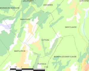
Ravilloles (Ravilloles)

- commune in Jura, France
 Hiking in Ravilloles
Ravilloles is a beautiful destination for hiking enthusiasts, known for its stunning landscapes and diverse trails. Here are some key points about hiking in Ravilloles:
-
Scenic Trails: The hiking trails in Ravilloles offer a variety of landscapes, including lush forests, rolling hills, and panoramic views. Each trail has its own unique features, ensuring that there are options for hikers of all skill levels.
-
Difficulty Levels: The area provides hikes ranging from easy, family-friendly paths to more challenging, rugged terrains for experienced hikers. This variety allows everyone to find a suitable trail based on their fitness level and hiking experience.
-
Wildlife and Nature: While hiking in Ravilloles, you may encounter a rich variety of wildlife and plant species. This includes birds, deer, and various local flora. It's a great opportunity for nature enthusiasts and photographers to enjoy and capture the beauty of the natural environment.
-
Seasonal Considerations: Each season brings its own charm to the trails. Spring and summer showcase blooming wildflowers and vibrant greenery, while autumn offers stunning fall foliage. Winter hikes can be magical as well, often transforming the landscape into a serene, snowy wonderland.
-
Safety Practices: As with any hiking expedition, it's essential to prepare adequately. Be sure to bring sufficient water, wear appropriate footwear, and dress in layers to accommodate changing weather conditions. Always check trail conditions and be mindful of local wildlife.
-
Local Guidance: Consider joining guided hikes or workshops if you're unfamiliar with the area. Local guides can provide insights into the region's ecology, history, and geography, enhancing your hiking experience.
-
Trail Access: Many trails in Ravilloles may be managed by local parks or conservation groups. Be sure to check for any access fees or permits if required.
Whether you're seeking a peaceful stroll through nature or a challenging trek, hiking in Ravilloles has something to offer for everyone. Always remember to practice Leave No Trace principles to preserve the beauty of the area for future visitors. Happy hiking!
- Country:

- Postal Code: 39170
- Coordinates: 46° 25' 32" N, 5° 48' 9" E


- GPS tracks (wikiloc): [Link]
- Area: 7.79 sq km
- Population: 491
- Wikipedia en: wiki(en)
- Wikipedia: wiki(fr)
- Wikidata storage: Wikidata: Q923657
- Wikipedia Commons Category: [Link]
- Freebase ID: [/m/03nth0s]
- GeoNames ID: Alt: [6433719]
- SIREN number: [213904535]
- BnF ID: [15258815d]
- INSEE municipality code: 39453
Shares border with regions:


Leschères
- commune in Jura, France
Hiking in Leschères
Leschères is a picturesque area in the Jura region of France, known for its stunning natural landscapes and hiking opportunities. When hiking in Leschères, you can expect to experience a variety of terrains and scenic views, including forests, meadows, and rocky outcrops....
- Country:
- Postal Code: 39170
- Coordinates: 46° 27' 7" N, 5° 49' 37" E
- GPS tracks (wikiloc): [Link]
- Area: 8.28 sq km
- Population: 215


Les Crozets
- commune in Jura, France
Hiking in Les Crozets
Les Crozets is a beautiful destination for hiking, particularly known for its stunning vistas and varied terrain. Located in the Jura Mountains in France, this area offers numerous trails suitable for hikers of different skill levels, from easy walks to more challenging treks....
- Country:
- Postal Code: 39260
- Coordinates: 46° 27' 37" N, 5° 47' 39" E
- GPS tracks (wikiloc): [Link]
- Area: 7.59 sq km
- Population: 204

Cuttura
- former commune in Jura, France
Hiking in Cuttura
Cuttura, a lesser-known but beautiful area, offers scenic landscapes that are ideal for hiking enthusiasts. While my specific information on Cuttura may be limited, here are some general hiking tips and things to consider when exploring the area:...
- Country:
- Postal Code: 39170
- Coordinates: 46° 24' 48" N, 5° 48' 41" E
- GPS tracks (wikiloc): [Link]
- Area: 5.95 sq km
- Population: 326


Moirans-en-Montagne
- commune in Jura, France
Hiking in Moirans-en-Montagne
Moirans-en-Montagne is a charming village located in the Jura region of France, known for its stunning natural landscapes and outdoor recreational opportunities. Here are some highlights about hiking in and around Moirans-en-Montagne:...
- Country:
- Postal Code: 39260
- Coordinates: 46° 25' 54" N, 5° 43' 32" E
- GPS tracks (wikiloc): [Link]
- Area: 26.56 sq km
- Population: 2088
- Web site: [Link]


Saint-Lupicin
- former commune in Jura, France
Hiking in Saint-Lupicin
Saint-Lupicin is a charming commune located in the Jura department of France, known for its picturesque landscapes and natural beauty. Hiking in this area offers a variety of options for both novice and experienced hikers. Here are some highlights of hiking in and around Saint-Lupicin:...
- Country:
- Postal Code: 39170
- Coordinates: 46° 23' 58" N, 5° 47' 31" E
- GPS tracks (wikiloc): [Link]
- Area: 9.54 sq km
- Population: 2056
- Web site: [Link]