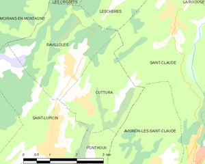
Saint-Lupicin (Saint-Lupicin)

- former commune in Jura, France
 Hiking in Saint-Lupicin
Saint-Lupicin is a charming commune located in the Jura department of France, known for its picturesque landscapes and natural beauty. Hiking in this area offers a variety of options for both novice and experienced hikers. Here are some highlights of hiking in and around Saint-Lupicin:
Trails and Scenery
-
Diverse Terrain: The region features a mix of forests, rolling hills, and open fields, providing a beautiful backdrop for hikers. You can expect to see scenic views of the Jura Mountains.
-
Forest Trails: Many trails wind through dense forests, offering opportunities to see wildlife, including deer, birds, and various plant species. The tranquility of the woods is ideal for nature lovers.
-
Lakes and Rivers: The nearby lakes and rivers, such as Lake Vouglans, provide additional hiking and walking routes, along with opportunities for fishing or picnicking.
Recommended Routes
-
Local Hiking Paths: There are several marked trails that start in or around Saint-Lupicin, allowing you to explore the surrounding countryside. Check local maps or visitor centers for trail recommendations.
-
Longer Trekking Routes: For those looking for a more extended hike, you can connect to the larger network of trails in the Jura Mountains. Some paths lead to higher elevations and offer panoramic views of the region.
Practical Information
-
Best Time to Hike: The best seasons for hiking in the Jura region are spring and autumn when the weather is mild, and the scenery is vibrant. Summer can be warmer and busier, while winter may offer opportunities for snowshoeing or cross-country skiing.
-
Preparation: Always prepare adequately before heading out. Bring enough water, wear appropriate footwear, and check the weather forecast. Some trails can be rugged, so having a good map or GPS app is advisable.
-
Local Regulations: Be mindful of local regulations regarding wildlife and the environment. Stick to marked trails and practice Leave No Trace principles to preserve the natural beauty.
Hiking in Saint-Lupicin allows you to immerse yourself in nature, enjoy the serene environment, and experience the charm of the Jura region. Whether you're looking for a short walk or a longer adventure, this area has much to offer.
- Country:

- Postal Code: 39170
- Coordinates: 46° 23' 58" N, 5° 47' 31" E


- GPS tracks (wikiloc): [Link]
- Area: 9.54 sq km
- Population: 2056
- Web site: https://www.saint-lupicin.com
- Wikipedia en: wiki(en)
- Wikipedia: wiki(fr)
- Wikidata storage: Wikidata: Q909992
- Wikipedia Commons Category: [Link]
- Freebase ID: [/m/03nvv2h]
- GeoNames ID: Alt: [6433745]
- BnF ID: [15258853z]
- PACTOLS thesaurus ID: [pcrtJt3paiAOPi]
- INSEE municipality code: 39491
Shares border with regions:


Ponthoux
- former commune in Jura, France
Hiking in Ponthoux
Ponthoux is a charming village located in the Alpes-Maritimes region of France, near the French Riviera. The surrounding area offers beautiful landscapes, featuring a mix of forests, hills, and views of the Mediterranean. Here are some key points to consider when hiking in and around Ponthoux:...
- Country:
- Postal Code: 39170
- Coordinates: 46° 23' 45" N, 5° 48' 39" E
- GPS tracks (wikiloc): [Link]
- AboveSeaLevel: 300 м m
- Area: 2.18 sq km
- Population: 75

Cuttura
- former commune in Jura, France
Hiking in Cuttura
Cuttura, a lesser-known but beautiful area, offers scenic landscapes that are ideal for hiking enthusiasts. While my specific information on Cuttura may be limited, here are some general hiking tips and things to consider when exploring the area:...
- Country:
- Postal Code: 39170
- Coordinates: 46° 24' 48" N, 5° 48' 41" E
- GPS tracks (wikiloc): [Link]
- Area: 5.95 sq km
- Population: 326


Moirans-en-Montagne
- commune in Jura, France
Hiking in Moirans-en-Montagne
Moirans-en-Montagne is a charming village located in the Jura region of France, known for its stunning natural landscapes and outdoor recreational opportunities. Here are some highlights about hiking in and around Moirans-en-Montagne:...
- Country:
- Postal Code: 39260
- Coordinates: 46° 25' 54" N, 5° 43' 32" E
- GPS tracks (wikiloc): [Link]
- Area: 26.56 sq km
- Population: 2088
- Web site: [Link]


Lavans-lès-Saint-Claude
- former commune in Jura, France
Hiking in Lavans-lès-Saint-Claude
Lavans-lès-Saint-Claude, now part of the commune of Saint-Claude in the Jura department of France, is an area rich in natural beauty and hiking opportunities. The region is renowned for its stunning landscapes, varied terrain, and abundant biodiversity, making it a fantastic spot for outdoor enthusiasts....
- Country:
- Postal Code: 39170
- Coordinates: 46° 23' 10" N, 5° 46' 56" E
- GPS tracks (wikiloc): [Link]
- Area: 11.65 sq km
- Population: 1916
- Web site: [Link]


Villards-d'Héria
- commune in Jura, France
Hiking in Villards-d'Héria
Villard-d'Héria is a charming destination in the Jura region of France, known for its stunning natural landscapes and outdoor activities, including several hiking opportunities. When hiking in Villard-d'Héria, you can expect a mix of rolling hills, lush forests, and picturesque valleys. Here are some key highlights and tips for hiking in this area:...
- Country:
- Postal Code: 39260
- Coordinates: 46° 25' 5" N, 5° 44' 5" E
- GPS tracks (wikiloc): [Link]
- Area: 9.91 sq km
- Population: 441


Ravilloles
- commune in Jura, France
Hiking in Ravilloles
Ravilloles is a beautiful destination for hiking enthusiasts, known for its stunning landscapes and diverse trails. Here are some key points about hiking in Ravilloles:...
- Country:
- Postal Code: 39170
- Coordinates: 46° 25' 32" N, 5° 48' 9" E
- GPS tracks (wikiloc): [Link]
- Area: 7.79 sq km
- Population: 491