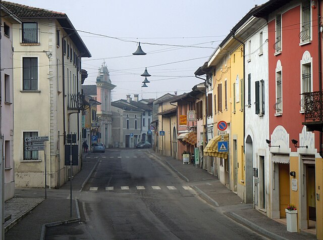
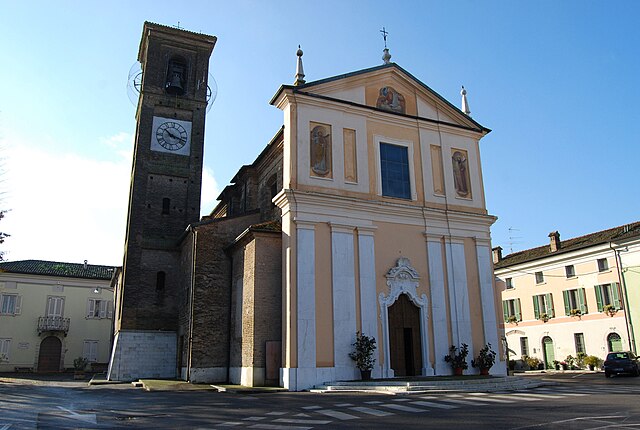
Remedello (Remedello)
.svg)
- Italian comune
 Hiking in Remedello
Remedello is a small town in the Lombardy region of northern Italy, surrounded by scenic landscapes that can offer enjoyable hiking opportunities. While the area is not as widely known for hiking as some other regions in Italy, it does feature beautiful natural surroundings, including rolling hills, vineyards, and picturesque views of the countryside.
Hiking Opportunities in and Around Remedello
-
Local Trails: Check for any marked local trails that may wind through the hills or agricultural areas around Remedello. These trails can provide a peaceful experience, showcasing the region's natural beauty and possibly leading to historical sites.
-
Parco Regionale dell'Adamello: A bit further afield, you can explore the Adamello Regional Park, which is about an hour's drive from Remedello. This park offers more challenging trails, stunning mountain scenery, and a variety of flora and fauna.
-
Vineyard Walks: The area around Remedello is known for its wine production. Consider taking a leisurely hike through the vineyards, where you can enjoy the landscapes and perhaps even stop for a wine tasting at a local vineyard.
-
Cultural Sites: Incorporate historical and cultural exploration into your hikes by planning routes that lead to nearby historical landmarks or churches in and around Remedello.
Tips for Hiking in Remedello
-
Maps and Resources: Always have a good map or a hiking app to help navigate the trails. Local tourist information offices can provide guidance and resources.
-
Weather Awareness: Check the weather conditions before heading out, as they can change quickly in the region.
-
Gear: Wear proper hiking shoes and bring sufficient water, snacks, and possibly sun protection, as rural trails may have limited amenities.
-
Local Regulations: Be mindful of any local regulations regarding wildlife, trail usage, and respect for private property.
Hiking in and around Remedello can provide a unique experience, combining outdoor activity with cultural exploration in a less-traveled part of Italy. Enjoy your adventure!
- Country:

- Postal Code: 25010
- Local Dialing Code: 030
- Licence Plate Code: BS
- Coordinates: 45° 16' 45" N, 10° 22' 22" E


- GPS tracks (wikiloc): [Link]
- AboveSeaLevel: 47 м m
- Area: 21.46 sq km
- Population: 3384
- Web site: http://www.comune.remedello.bs.it
- Wikipedia en: wiki(en)
- Wikipedia: wiki(it)
- Wikidata storage: Wikidata: Q111595
- Wikipedia Commons Category: [Link]
- Freebase ID: [/m/047nrr]
- GeoNames ID: Alt: [6542779]
- VIAF ID: Alt: [238115268]
- OSM relation ID: [44550]
- TGN ID: [6004961]
- UN/LOCODE: [ITRMD]
- ISTAT ID: 017160
- Italian cadastre code: H230
Shares border with regions:

Acquafredda
- Italian comune
Hiking in Acquafredda
Acquafredda is a charming coastal area located in southern Italy, specifically in the region of Basilicata. It offers various opportunities for hiking enthusiasts to explore its beautiful landscapes, featuring a mix of coastal views, rugged cliffs, and lush greenery. Here are some highlights about hiking in Acquafredda:...
- Country:
- Postal Code: 25010
- Local Dialing Code: 030
- Licence Plate Code: BS
- Coordinates: 45° 18' 25" N, 10° 24' 48" E
- GPS tracks (wikiloc): [Link]
- AboveSeaLevel: 56 м m
- Area: 9 sq km
- Population: 1565
- Web site: [Link]

Fiesse
- Italian comune
Hiking in Fiesse
Fiesse is a small town located in the province of Brescia, Lombardy, Italy. While it may not be a well-known hiking destination compared to some of the larger national parks or regions in Italy, it is situated within a beautiful area that offers access to various hiking opportunities in the surrounding countryside and the larger Lombardy region....
- Country:
- Postal Code: 25020
- Local Dialing Code: 030
- Licence Plate Code: BS
- Coordinates: 45° 13' 57" N, 10° 19' 31" E
- GPS tracks (wikiloc): [Link]
- AboveSeaLevel: 39 м m
- Area: 16.02 sq km
- Population: 2041
- Web site: [Link]
Gambara
- Italian comune
Hiking in Gambara
Gambara is a small town located in the Lombardy region of Italy, known for its picturesque countryside, charming landscapes, and proximity to various natural areas suitable for hiking. While Gambara itself may not have extensive hiking trails, it serves as a great gateway to explore the surrounding areas that offer beautiful hiking experiences....
- Country:
- Postal Code: 25020
- Local Dialing Code: 030
- Licence Plate Code: BS
- Coordinates: 45° 15' 22" N, 10° 17' 40" E
- GPS tracks (wikiloc): [Link]
- AboveSeaLevel: 51 м m
- Area: 31.59 sq km
- Population: 4743
- Web site: [Link]

Isorella
- Italian comune
Hiking in Isorella
Isorella is a charming municipality located in the Lombardy region of Italy, known for its picturesque landscapes and tranquil natural settings. While it may not be as widely known for hiking as some other regions in Italy, there are definitely some opportunities for outdoor activities....
- Country:
- Postal Code: 25010
- Local Dialing Code: 030
- Licence Plate Code: BS
- Coordinates: 45° 18' 33" N, 10° 19' 24" E
- GPS tracks (wikiloc): [Link]
- AboveSeaLevel: 56 м m
- Area: 15.33 sq km
- Population: 4077
- Web site: [Link]
Visano
- Italian comune in the Province of Brescia
Hiking in Visano
Visano, a quaint small town in the Lombardy region of Italy, is not widely known for extensive hiking trails like some other areas in Italy. However, it is situated close to beautiful natural landscapes, including the Alps and the Po River, making it a great starting point for hiking adventures....
- Country:
- Postal Code: 25010
- Local Dialing Code: 030
- Licence Plate Code: BS
- Coordinates: 45° 19' 9" N, 10° 22' 24" E
- GPS tracks (wikiloc): [Link]
- AboveSeaLevel: 59 м m
- Area: 11.22 sq km
- Population: 1956
- Web site: [Link]


Casalmoro
- Italian comune
Hiking in Casalmoro
Casalmoro is a picturesque village located in northern Italy, known for its stunning natural landscapes and hiking opportunities. While specific trails can vary, the area generally offers various routes suitable for different skill levels, ranging from easy walks to more challenging hikes....
- Country:
- Postal Code: 46040
- Local Dialing Code: 0376
- Licence Plate Code: MN
- Coordinates: 45° 16' 0" N, 10° 24' 0" E
- GPS tracks (wikiloc): [Link]
- AboveSeaLevel: 47 м m
- Area: 13.7 sq km
- Population: 2240
- Web site: [Link]


Asola
- Italian comune
Hiking in Asola
Asola, located in the Lombardy region of Italy, offers various hiking opportunities that beautifully showcase the area's natural landscapes and cultural heritage. While it may not be as renowned as some of the bigger hiking destinations in Italy, it provides a more tranquil and less crowded experience for those who wish to explore the countryside....
- Country:
- Postal Code: 46041
- Local Dialing Code: 0376
- Licence Plate Code: MN
- Coordinates: 45° 13' 0" N, 10° 25' 0" E
- GPS tracks (wikiloc): [Link]
- AboveSeaLevel: 42 м m
- Area: 73.48 sq km
- Population: 10069
- Web site: [Link]