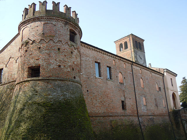
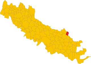
Gambara (Gambara)
.svg)
- Italian comune
 Hiking in Gambara
Gambara is a small town located in the Lombardy region of Italy, known for its picturesque countryside, charming landscapes, and proximity to various natural areas suitable for hiking. While Gambara itself may not have extensive hiking trails, it serves as a great gateway to explore the surrounding areas that offer beautiful hiking experiences.
Nearby Hiking Opportunities:
-
Parco Regionale dell'Oglio Sud: This regional park offers a network of trails along the Oglio River and through forests and agricultural lands. It's a great spot for a leisurely hike, cycling, or bird watching.
-
Monte Netto: Located a short drive from Gambara, Monte Netto offers trails with varying difficulty levels, providing stunning views of the surrounding countryside and the nearby hills.
-
Franciacorta: This region is famous for its vineyards and rolling hills. There are several trails that meander through vineyards and offer opportunities to enjoy local wines and cuisine along the way.
-
The Brescia Hills: Just to the north of Gambara, the Brescia hills provide numerous hiking trails with varying levels of difficulty, ideal for both novice and experienced hikers.
Tips for Hiking in the Area:
- Trail Maps: Make sure to obtain trail maps or download hiking apps prior to your hike, as some areas may not have clearly marked trails.
- Weather Considerations: Check the weather forecast before heading out, as conditions can change quickly.
- Safety Gear: Always wear appropriate footwear and carry essentials like water, snacks, a first-aid kit, and a map or GPS device.
- Respect Nature: Follow the Leave No Trace principles, ensuring you respect the environment and wildlife during your hikes.
Local Culture:
When hiking in and around Gambara, take the opportunity to experience local culture, cuisine, and wines. The area is known for its delicious food, including specialties of the Lombardy region, making it a perfect place to unwind after a long hike.
Conclusion:
While Gambara itself may not be a hiking hotspot, it is beautifully positioned near various trails and natural landscapes. With its serene environment and access to charming Italian culture, it provides a fantastic base for those looking to explore the outdoors in Lombardy. Enjoy your hiking adventures!
- Country:

- Postal Code: 25020
- Local Dialing Code: 030
- Licence Plate Code: BS
- Coordinates: 45° 15' 22" N, 10° 17' 40" E


- GPS tracks (wikiloc): [Link]
- AboveSeaLevel: 51 м m
- Area: 31.59 sq km
- Population: 4743
- Web site: http://www.comune.gambara.bs.it/
- Wikipedia en: wiki(en)
- Wikipedia: wiki(it)
- Wikidata storage: Wikidata: Q104616
- Wikipedia Commons Category: [Link]
- Freebase ID: [/m/043p71]
- GeoNames ID: Alt: [6539625]
- VIAF ID: Alt: [158467230]
- OSM relation ID: [44490]
- archINFORM location ID: [46026]
- UN/LOCODE: [ITGMB]
- ISTAT ID: 017073
- Italian cadastre code: D891
Shares border with regions:

Fiesse
- Italian comune
Hiking in Fiesse
Fiesse is a small town located in the province of Brescia, Lombardy, Italy. While it may not be a well-known hiking destination compared to some of the larger national parks or regions in Italy, it is situated within a beautiful area that offers access to various hiking opportunities in the surrounding countryside and the larger Lombardy region....
- Country:
- Postal Code: 25020
- Local Dialing Code: 030
- Licence Plate Code: BS
- Coordinates: 45° 13' 57" N, 10° 19' 31" E
- GPS tracks (wikiloc): [Link]
- AboveSeaLevel: 39 м m
- Area: 16.02 sq km
- Population: 2041
- Web site: [Link]

Gottolengo
- Italian comune
Hiking in Gottolengo
Gottolengo is a small town in the Lombardy region of Italy, located in the province of Brescia. While it may not be as famous for hiking as some of the larger national parks or mountains in the area, there are still opportunities to enjoy the beautiful Italian countryside through walking and exploring the scenic surroundings....
- Country:
- Postal Code: 25023
- Local Dialing Code: 030
- Licence Plate Code: BS
- Coordinates: 45° 17' 34" N, 10° 16' 24" E
- GPS tracks (wikiloc): [Link]
- AboveSeaLevel: 53 м m
- Area: 29.28 sq km
- Population: 5184
- Web site: [Link]

Isorella
- Italian comune
Hiking in Isorella
Isorella is a charming municipality located in the Lombardy region of Italy, known for its picturesque landscapes and tranquil natural settings. While it may not be as widely known for hiking as some other regions in Italy, there are definitely some opportunities for outdoor activities....
- Country:
- Postal Code: 25010
- Local Dialing Code: 030
- Licence Plate Code: BS
- Coordinates: 45° 18' 33" N, 10° 19' 24" E
- GPS tracks (wikiloc): [Link]
- AboveSeaLevel: 56 м m
- Area: 15.33 sq km
- Population: 4077
- Web site: [Link]

Pralboino
- Italian comune
Hiking in Pralboino
Pralboino is a small town located in the Lombardy region of Italy. While it may not be as well-known as some of the larger towns in the area, it offers opportunities for hiking and outdoor activities. Here are some insights about hiking in and around Pralboino:...
- Country:
- Postal Code: 25020
- Local Dialing Code: 030
- Licence Plate Code: BS
- Coordinates: 45° 16' 6" N, 10° 13' 6" E
- GPS tracks (wikiloc): [Link]
- AboveSeaLevel: 47 м m
- Area: 17.16 sq km
- Population: 2938
- Web site: [Link]
Remedello
- Italian comune
Hiking in Remedello
Remedello is a small town in the Lombardy region of northern Italy, surrounded by scenic landscapes that can offer enjoyable hiking opportunities. While the area is not as widely known for hiking as some other regions in Italy, it does feature beautiful natural surroundings, including rolling hills, vineyards, and picturesque views of the countryside....
- Country:
- Postal Code: 25010
- Local Dialing Code: 030
- Licence Plate Code: BS
- Coordinates: 45° 16' 45" N, 10° 22' 22" E
- GPS tracks (wikiloc): [Link]
- AboveSeaLevel: 47 м m
- Area: 21.46 sq km
- Population: 3384
- Web site: [Link]


Asola
- Italian comune
Hiking in Asola
Asola, located in the Lombardy region of Italy, offers various hiking opportunities that beautifully showcase the area's natural landscapes and cultural heritage. While it may not be as renowned as some of the bigger hiking destinations in Italy, it provides a more tranquil and less crowded experience for those who wish to explore the countryside....
- Country:
- Postal Code: 46041
- Local Dialing Code: 0376
- Licence Plate Code: MN
- Coordinates: 45° 13' 0" N, 10° 25' 0" E
- GPS tracks (wikiloc): [Link]
- AboveSeaLevel: 42 м m
- Area: 73.48 sq km
- Population: 10069
- Web site: [Link]

Ostiano
- Italian comune
Hiking in Ostiano
Ostiano, located in the Lombardy region of Italy, offers a unique opportunity for hiking enthusiasts to explore its scenic landscapes and local culture. While Ostiano itself may not be as widely recognized for extensive hiking trails as some other Italian regions, it serves as a gateway to the surrounding areas that are rich in natural beauty and potential hiking routes....
- Country:
- Postal Code: 26032
- Local Dialing Code: 0372
- Licence Plate Code: CR
- Coordinates: 45° 13' 0" N, 10° 15' 0" E
- GPS tracks (wikiloc): [Link]
- AboveSeaLevel: 43 м m
- Area: 19.49 sq km
- Population: 2945
- Web site: [Link]

Volongo
- Italian comune
Hiking in Volongo
Volongo isn't a widely recognized hiking destination, and it seems there might be some confusion regarding its location or its prominence in hiking circles. However, if you're looking for information about hiking in a specific place—perhaps a region, a park, or a mountain range in a country—please provide more details so I can assist you better....
- Country:
- Postal Code: 26030
- Local Dialing Code: 0372
- Licence Plate Code: CR
- Coordinates: 45° 12' 42" N, 10° 18' 9" E
- GPS tracks (wikiloc): [Link]
- AboveSeaLevel: 43 м m
- Area: 8.12 sq km
- Population: 525
- Web site: [Link]