Rochefort (Rochefort)

- commune in Savoie, France
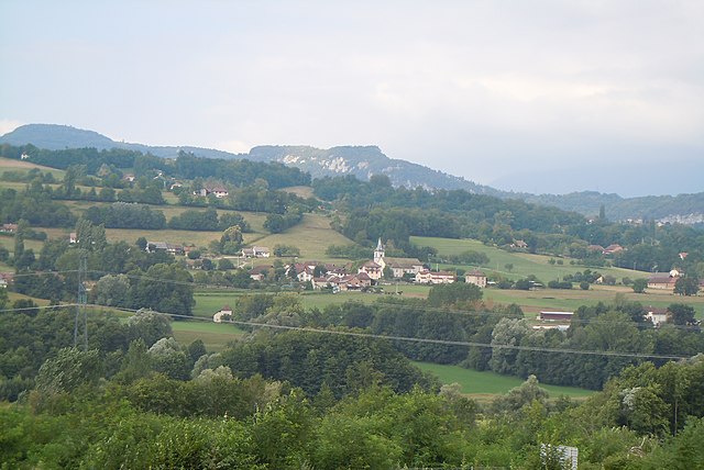
 Hiking in Rochefort
Rochefort is a charming village located in the Savoie region of the French Alps, which is known for its stunning alpine scenery, beautiful landscapes, and fantastic hiking opportunities. Here are some highlights and tips for hiking in and around Rochefort:
Scenic Trails
-
GR96 (Grande Randonnée 96): This European long-distance trail runs through the area and offers breathtaking views of the surrounding mountains and valleys. Parts of this trail are accessible from Rochefort.
-
Local Trails: There are numerous well-marked local trails that cater to various skill levels. You can find family-friendly walks as well as more challenging paths that ascend to higher altitudes.
-
Alpine Lakes: Several hiking routes will lead you to stunning alpine lakes in the vicinity, perfect for a picnic or a serene moment amidst nature.
Nature and Wildlife
- The region is rich in biodiversity, making it a great spot for observing wildlife, including marmots, chamois, and a variety of birds. Be sure to bring your binoculars for some birdwatching along the trails.
Best Times to Hike
- Summer (June to September): The most popular time for hiking. The weather is generally mild and the trails are accessible.
- Autumn (September to October): Offers beautiful fall colors and fewer crowds. A great time for photography!
- Spring (May): Wildflowers start to bloom, but trails may still be muddy or snow-covered in higher elevations.
- Winter: While hiking may be limited, the area is also popular for snowshoeing and winter hiking.
Preparation
- Gear: Wear sturdy hiking boots, bring sufficient water, snacks, a map or GPS device, and dress in layers to accommodate changing weather conditions.
- Safety: Always check local trail conditions before heading out, inform someone of your plans, and consider going with a hiking group if you’re unfamiliar with the area.
Local Amenities
- Rochefort is usually well-equipped with local amenities, including accommodations, restaurants, and shops for supplies. Take advantage of local knowledge by asking locals for trail recommendations or tips.
Guided Hiking
- If you're new to hiking or exploring the area, consider hiring a local guide who can provide valuable insight into the geography, flora, and fauna of the region.
Hiking in Rochefort presents an excellent way to experience the natural beauty of the Savoie region while also offering the chance to immerse yourself in the local culture. Enjoy your hiking adventure!
- Country:

- Postal Code: 73240
- Coordinates: 45° 34' 56" N, 5° 43' 20" E


- GPS tracks (wikiloc): [Link]
- Area: 5.6 sq km
- Population: 216
- Wikipedia en: wiki(en)
- Wikipedia: wiki(fr)
- Wikidata storage: Wikidata: Q1216969
- Wikipedia Commons Category: [Link]
- Freebase ID: [/m/03qlmzg]
- GeoNames ID: Alt: [6454652]
- SIREN number: [217302140]
- BnF ID: [15274145v]
- INSEE municipality code: 73214
Shares border with regions:


Novalaise
- commune in Savoie, France
Hiking in Novalaise
Novalaise is a charming commune located in the Savoie department of the Auvergne-Rhône-Alpes region in southeastern France. Nestled between the picturesque shores of Lake Aiguebelette and the surrounding mountains, it presents excellent opportunities for hiking enthusiasts....
- Country:
- Postal Code: 73470
- Coordinates: 45° 35' 40" N, 5° 46' 18" E
- GPS tracks (wikiloc): [Link]
- Area: 16.26 sq km
- Population: 2067


Sainte-Marie-d'Alvey
- commune in Savoie, France
Hiking in Sainte-Marie-d'Alvey
Sainte-Marie-d'Alvey is a charming commune located in the Auvergne-Rhône-Alpes region of France. It’s not as well-known for hiking as some larger areas, but it offers beautiful landscapes and trails for those looking to enjoy nature. Here are some aspects to consider when hiking in Sainte-Marie-d'Alvey:...
- Country:
- Postal Code: 73240
- Coordinates: 45° 35' 36" N, 5° 43' 14" E
- GPS tracks (wikiloc): [Link]
- Area: 2.61 sq km
- Population: 120

Avressieux
- commune in Savoie, France
Hiking in Avressieux
Avressieux is a charming village located in the Auvergne-Rhône-Alpes region of France, in the department of Savoie. It is situated at the edge of beautiful natural landscapes, making it an appealing destination for hiking enthusiasts....
- Country:
- Postal Code: 73240
- Coordinates: 45° 34' 20" N, 5° 41' 41" E
- GPS tracks (wikiloc): [Link]
- Area: 8.07 sq km
- Population: 517


Gresin
- commune in Savoie, France
Hiking in Gresin
Gresin, located in the Aosta Valley region of Italy, is a wonderful destination for hiking enthusiasts. The area offers stunning mountainous landscapes, lush valleys, and a plethora of trails suitable for various skill levels....
- Country:
- Postal Code: 73240
- Coordinates: 45° 36' 36" N, 5° 40' 57" E
- GPS tracks (wikiloc): [Link]
- Area: 5.01 sq km
- Population: 387


Saint-Genix-sur-Guiers
- commune in Savoie, France
Hiking in Saint-Genix-sur-Guiers
Saint-Genix-sur-Guiers is a charming commune located in the Rhône-Alpes region of France, known for its beautiful scenery and access to hiking trails. Nestled at the foot of the Chartreuse Mountains, it offers a variety of outdoor activities, including hiking, with trails that cater to different skill levels....
- Country:
- Postal Code: 73240
- Coordinates: 45° 36' 2" N, 5° 38' 4" E
- GPS tracks (wikiloc): [Link]
- Area: 12.27 sq km
- Population: 2384


Ayn, Savoie
- commune in Savoie, France
Hiking in Ayn, Savoie
Ayn, located in the Savoie department of the Auvergne-Rhône-Alpes region in France, is surrounded by stunning natural beauty, making it an excellent destination for hiking enthusiasts. Here are some key points about hiking in and around Ayn:...
- Country:
- Postal Code: 73470
- Coordinates: 45° 34' 21" N, 5° 45' 3" E
- GPS tracks (wikiloc): [Link]
- Area: 7.44 sq km
- Population: 359


Verel-de-Montbel
- commune in Savoie, France
Hiking in Verel-de-Montbel
Verel-de-Montbel is a charming commune located in the Auvergne-Rhône-Alpes region of France, nestled at the edge of the Chartreuse Mountains. Hiking in this area offers a wonderful opportunity to explore scenic landscapes, diverse flora, and panoramic views of the surrounding mountains and lakes....
- Country:
- Postal Code: 73330
- Coordinates: 45° 33' 33" N, 5° 43' 49" E
- GPS tracks (wikiloc): [Link]
- Area: 3.74 sq km
- Population: 299