Rochefourchat (Rochefourchat)

- commune in Drôme, France
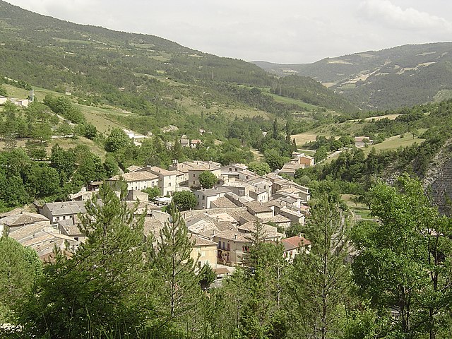
 Hiking in Rochefourchat
Rochefourchat is a lesser-known destination in the Drôme region of southeastern France, offering a unique hiking experience amid stunning natural landscapes. Here's what you can expect when hiking in Rochefourchat:
Highlights of Rochefourchat Hiking:
-
Scenic Views: The area is characterized by its dramatic cliffs, rolling hills, and lush vegetation, making it an ideal spot for photography and enjoying nature.
-
Historical Interest: Rochefourchat is known for its ancient ruins, notably the remnants of old stone houses that date back to medieval times. Exploring these ruins adds a rich historical context to your hike.
-
Diverse Trails: You can find a variety of hiking trails that cater to different skill levels. Whether you're a beginner or an experienced hiker, there are options for you.
-
Flora and Fauna: The region is home to diverse plant life and wildlife, providing excellent opportunities for birdwatching and nature enthusiasts to observe various species in their natural habitat.
-
Peace and Quiet: Compared to more popular hiking destinations in France, Rochefourchat tends to be less crowded, allowing for a more tranquil outdoor experience.
Practical Tips:
-
Trail Maps: Before heading out, it’s advised to obtain a map of the area. Local tourism offices or hiking clubs can provide detailed maps and trail information.
-
Weather Considerations: Check the weather forecast as conditions can change rapidly in mountainous regions. Dress in layers and be prepared for rain or cooler temperatures.
-
Food and Water: Bring enough water and snacks since facilities may be limited in the area. Pack a picnic for a scenic break along your hike!
-
Footwear: Proper hiking shoes or boots with good grip are essential for navigating the rocky terrain and varying trail conditions.
-
Start Early: To make the most of your day, start early, as trails can take several hours to traverse.
Getting There:
Rochefourchat is accessible by car, with parking available in nearby villages or trailheads. The nearest larger towns are Montélimar and Dieulefit, where you can stock up on supplies before your hike.
Conclusion:
Hiking in Rochefourchat offers a wonderful blend of natural beauty and historical intrigue. Whether you’re seeking solitude or a chance to connect with nature, this hidden gem in the Drôme region is a rewarding destination for hiking enthusiasts. Always be sure to respect the local environment and follow Leave No Trace principles during your visit!
- Country:

- Postal Code: 26340
- Coordinates: 44° 35' 55" N, 5° 14' 50" E


- GPS tracks (wikiloc): [Link]
- Area: 12.74 sq km
- Population: 1
- Wikipedia en: wiki(en)
- Wikipedia: wiki(fr)
- Wikidata storage: Wikidata: Q323644
- Wikipedia Commons Category: [Link]
- Freebase ID: [/m/0h3vp2]
- GeoNames ID: Alt: [2983260]
- SIREN number: [212602742]
- BnF ID: [15253134j]
- INSEE municipality code: 26274
Shares border with regions:

Saint-Nazaire-le-Désert
- commune in Drôme, France
Hiking in Saint-Nazaire-le-Désert
Saint-Nazaire-le-Désert is a charming commune located in the Drôme department in southeastern France. It offers a unique blend of natural beauty, historical significance, and outdoor activities, making it a great destination for hiking enthusiasts....
- Country:
- Postal Code: 26340
- Coordinates: 44° 34' 12" N, 5° 16' 33" E
- GPS tracks (wikiloc): [Link]
- Area: 46.62 sq km
- Population: 174


La Chaudière
- commune in Drôme, France
Hiking in La Chaudière
La Chaudière is a beautiful region located in Quebec, Canada, known for its stunning natural landscapes and outdoor recreational opportunities. Here are some key points about hiking in La Chaudière:...
- Country:
- Postal Code: 26340
- Coordinates: 44° 37' 54" N, 5° 12' 59" E
- GPS tracks (wikiloc): [Link]
- Area: 12.17 sq km
- Population: 21
Les Tonils
- commune in Drôme, France
Hiking in Les Tonils
Les Tonils, located in the province of Aosta Valley in Italy, is a beautiful area for hiking, known for its stunning landscapes and diverse flora and fauna. The region offers routes that cater to various skill levels, from easy day hikes to more challenging treks....
- Country:
- Postal Code: 26460
- Coordinates: 44° 34' 55" N, 5° 11' 57" E
- GPS tracks (wikiloc): [Link]
- Area: 13 sq km
- Population: 17
Pradelle
- commune in Drôme, France
Hiking in Pradelle
Pradelle, located in the Drôme department in southeastern France, offers a delightful setting for hiking enthusiasts. Nestled in the beautiful landscape of the Drôme Provençale region, it boasts picturesque views, rolling hills, and diverse flora and fauna....
- Country:
- Postal Code: 26340
- Coordinates: 44° 36' 29" N, 5° 17' 31" E
- GPS tracks (wikiloc): [Link]
- Area: 12.92 sq km
- Population: 19