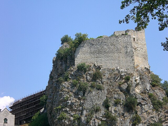
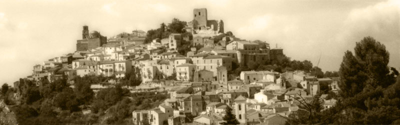
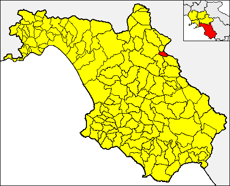
Romagnano al Monte (Romagnano al Monte)

- Italian comune
 Hiking in Romagnano al Monte
Romagnano al Monte is a small village located in the province of Salerno, in the Campania region of Italy. Nestled in the hills of the Cilento and Vallo di Diano National Park, it offers a variety of hiking opportunities that showcase the stunning natural landscapes and rich biodiversity of the area.
Hiking Opportunities:
-
Scenic Trails:
- The region boasts several marked trails ranging from easy to moderate difficulty, suitable for both novice and experienced hikers. These trails often wind through lush forests, olive groves, and along slopes with breathtaking views of the surrounding mountains and valleys.
-
Cilento National Park:
- Romagnano al Monte is close to the Cilento and Vallo di Diano National Park, which has an extensive network of hiking paths. The park is known for its diverse ecosystems and archaeological sites. Hikers can explore routes that lead to ancient ruins, such as those found in Paestum and Velia.
-
Local Flora and Fauna:
- The area is rich in biodiversity, and while hiking, you may encounter various wildlife and plant species unique to this part of Italy. Make sure to keep your camera ready for the stunning views and potential wildlife sightings!
-
Cultural Experiences:
- Besides the natural beauty, hiking in Romagnano al Monte allows you to experience local culture. You might pass through small villages, witness traditional agricultural practices, and have the opportunity to taste local cuisine at small eateries.
-
Seasonal Considerations:
- The best time for hiking in this area is typically in the spring (April to June) and early autumn (September to October) when temperatures are mild and the scenery is vibrant. Summer can be hot, so it’s essential to start hikes early in the day.
Tips for Hiking in Romagnano al Monte:
- Respect Nature: Stay on designated trails and avoid disturbing wildlife and plants.
- Stay Hydrated: Bring enough water, especially during warmer months.
- Dress Appropriately: Wear comfortable hiking shoes and dress for the weather, considering layers if necessary.
- Check Maps and Local Guides: Familiarize yourself with the area using maps, and consider hiring local guides for a more enriched experience.
- Inform Others: Let someone know your hiking plans and estimated return time, especially if you are hiking alone.
Hiking in Romagnano al Monte provides a blend of natural beauty, cultural experiences, and opportunities for adventure. Whether you're looking to enjoy a peaceful day in nature or challenge yourself with more ambitious hikes, this area has something to offer every hiker.
- Country:

- Postal Code: 84020
- Local Dialing Code: 0828
- Licence Plate Code: SA
- Coordinates: 40° 37' 41" N, 15° 27' 29" E


- GPS tracks (wikiloc): [Link]
- AboveSeaLevel: 650 м m
- Area: 9.67 sq km
- Population: 375
- Web site: http://romagnanoalmonte.asmenet.it
- Wikipedia en: wiki(en)
- Wikipedia: wiki(it)
- Wikidata storage: Wikidata: Q81458
- Wikipedia Commons Category: [Link]
- GeoNames ID: Alt: [6537411]
- BnF ID: [14543285w]
- VIAF ID: Alt: [142087697]
- OSM relation ID: [40629]
- GND ID: Alt: [4575054-3]
- Library of Congress authority ID: Alt: [n2002025349]
- SUDOC authorities ID: [180744852]
- National Library of Israel ID: [001062905]
- FAST ID: [1296420]
- ISTAT ID: 065110
- Italian cadastre code: H503
Shares border with regions:

Balvano
- Italian comune
Hiking in Balvano
Balvano, located in the Basilicata region of southern Italy, offers beautiful landscapes and varied hiking opportunities for outdoor enthusiasts. The area is characterized by its scenic hills, chestnut and oak forests, and beautiful valleys, making it perfect for nature lovers....
- Country:
- Postal Code: 85050
- Local Dialing Code: 0971
- Licence Plate Code: PZ
- Coordinates: 40° 39' 0" N, 15° 31' 0" E
- GPS tracks (wikiloc): [Link]
- AboveSeaLevel: 425 м m
- Area: 42.15 sq km
- Population: 1828
- Web site: [Link]


Vietri di Potenza
- Italian comune
Hiking in Vietri di Potenza
Vietri di Potenza is a charming village located in the heart of the Basilicata region in southern Italy. This area is surrounded by the beautiful Lucanian Apennines, making it a fantastic location for hiking enthusiasts. Here are some highlights and considerations for hiking in this area:...
- Country:
- Postal Code: 85058
- Local Dialing Code: 0971
- Licence Plate Code: PZ
- Coordinates: 40° 36' 0" N, 15° 30' 0" E
- GPS tracks (wikiloc): [Link]
- AboveSeaLevel: 405 м m
- Area: 52.25 sq km
- Population: 2787
- Web site: [Link]

Buccino
- Italian comune
Hiking in Buccino
Buccino is a town located in the province of Salerno in the Campania region of Italy. Nestled in the Apennine Mountains, it offers a range of outdoor activities, including hiking, thanks to its beautiful landscapes and rich history. Here are some insights about hiking in and around Buccino:...
- Country:
- Postal Code: 84021
- Local Dialing Code: 0828
- Licence Plate Code: SA
- Coordinates: 40° 38' 0" N, 15° 23' 0" E
- GPS tracks (wikiloc): [Link]
- AboveSeaLevel: 663 м m
- Area: 65.92 sq km
- Population: 4889
- Web site: [Link]


Ricigliano
- Italian comune
Hiking in Ricigliano
Ricigliano is a charming village located in the Campania region of southern Italy, known for its picturesque landscapes and rich cultural history. Hiking in and around Ricigliano offers the opportunity to explore scenic trails that boast beautiful views of the surrounding hills and the picturesque countryside....
- Country:
- Postal Code: 84020
- Local Dialing Code: 0828
- Licence Plate Code: SA
- Coordinates: 40° 40' 0" N, 15° 29' 0" E
- GPS tracks (wikiloc): [Link]
- AboveSeaLevel: 560 м m
- Area: 27.92 sq km
- Population: 1116
- Web site: [Link]

Salvitelle
- Italian comune
Hiking in Salvitelle
Salvitelle is a picturesque village located in the province of Salerno in the Campania region of Italy, nestled in the Apennine Mountains. Hiking in and around Salvitelle offers a fantastic way to explore the natural beauty, rich history, and charming landscapes of this area....
- Country:
- Postal Code: 84020
- Local Dialing Code: 0975
- Licence Plate Code: SA
- Coordinates: 40° 36' 0" N, 15° 28' 0" E
- GPS tracks (wikiloc): [Link]
- AboveSeaLevel: 630 м m
- Area: 9.6 sq km
- Population: 526
- Web site: [Link]
San Gregorio Magno
- Italian comune
Hiking in San Gregorio Magno
San Gregorio Magno is a charming town located in the Campania region of Italy, surrounded by the beautiful landscapes of the Cilento and Vallo di Diano National Park. This area offers a variety of hiking opportunities, ranging from easy walks to more challenging trails through natural parks, mountains, and historical sites....
- Country:
- Postal Code: 84020
- Local Dialing Code: 0828
- Licence Plate Code: SA
- Coordinates: 40° 39' 0" N, 15° 24' 0" E
- GPS tracks (wikiloc): [Link]
- AboveSeaLevel: 508 м m
- Area: 50.05 sq km
- Population: 4221
- Web site: [Link]