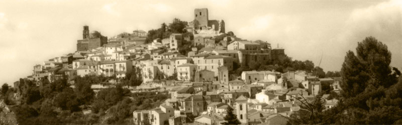
San Gregorio Magno (San Gregorio Magno)

- Italian comune
 Hiking in San Gregorio Magno
San Gregorio Magno is a charming town located in the Campania region of Italy, surrounded by the beautiful landscapes of the Cilento and Vallo di Diano National Park. This area offers a variety of hiking opportunities, ranging from easy walks to more challenging trails through natural parks, mountains, and historical sites.
Hiking Opportunities
-
Cilento and Vallo di Diano National Park: This UNESCO World Heritage site boasts a vast network of hiking trails. Some popular routes include:
- Sentiero degli Dei (Path of the Gods): A scenic trail known for its breathtaking views and unique rock formations.
- Monte Stella: A trail leading to one of the highest peaks in the area, offering stunning panoramas of the surrounding hills and valleys.
-
Historical Sites: While hiking, you may come across ancient ruins, hermitages, and medieval villages that offer a glimpse into the rich history of the region.
-
Nature Trails: The area is home to diverse flora and fauna, making it a great destination for nature lovers. Be on the lookout for wildlife and unique plant species as you hike.
Tips for Hiking in San Gregorio Magno
- Safety First: Always inform someone about your hiking plans, carry a map or GPS, and ensure you have enough water and snacks.
- Wear Appropriate Gear: Sturdy hiking boots, weather-appropriate clothing, and a hat for sun protection are essential.
- Check Weather Conditions: Before heading out, check the local weather to ensure safe hiking conditions.
- Respect Nature: Follow the Leave No Trace principles to preserve the natural beauty of the area.
Local Guides and Tours
For those who prefer a guided experience, consider joining a local hiking tour. Guides can provide valuable insights into the area's ecology, history, and culture, enhancing your hiking experience.
Conclusion
Exploring the hiking trails around San Gregorio Magno is a fantastic way to enjoy the natural beauty of the Italian countryside while immersing yourself in the local culture and history. Whether you are an experienced hiker or a beginner, you will find trails suitable for your level of fitness and experience.
- Country:

- Postal Code: 84020
- Local Dialing Code: 0828
- Licence Plate Code: SA
- Coordinates: 40° 39' 0" N, 15° 24' 0" E


- GPS tracks (wikiloc): [Link]
- AboveSeaLevel: 508 м m
- Area: 50.05 sq km
- Population: 4221
- Web site: http://www.comune.san-gregorio-di-catania.ct.it
- Wikipedia en: wiki(en)
- Wikipedia: wiki(it)
- Wikidata storage: Wikidata: Q81544
- Wikipedia Commons Category: [Link]
- GeoNames ID: Alt: [6538830]
- VIAF ID: Alt: [145573097]
- OSM relation ID: [40659]
- UN/LOCODE: [ITS2B]
- ISTAT ID: 065120
- Italian cadastre code: H943
Shares border with regions:


Muro Lucano
- Italian comune
Hiking in Muro Lucano
Muro Lucano is a picturesque town located in the Basilicata region of southern Italy, known for its stunning landscapes, historical sites, and rich cultural heritage. Hiking in and around Muro Lucano offers an excellent opportunity to explore the natural beauty of the area, including its mountains, valleys, and rivers. Here are some insights for hiking in this region:...
- Country:
- Postal Code: 85054
- Local Dialing Code: 0976
- Licence Plate Code: PZ
- Coordinates: 40° 45' 0" N, 15° 29' 0" E
- GPS tracks (wikiloc): [Link]
- AboveSeaLevel: 600 м m
- Area: 126.18 sq km
- Population: 5344
- Web site: [Link]

Buccino
- Italian comune
Hiking in Buccino
Buccino is a town located in the province of Salerno in the Campania region of Italy. Nestled in the Apennine Mountains, it offers a range of outdoor activities, including hiking, thanks to its beautiful landscapes and rich history. Here are some insights about hiking in and around Buccino:...
- Country:
- Postal Code: 84021
- Local Dialing Code: 0828
- Licence Plate Code: SA
- Coordinates: 40° 38' 0" N, 15° 23' 0" E
- GPS tracks (wikiloc): [Link]
- AboveSeaLevel: 663 м m
- Area: 65.92 sq km
- Population: 4889
- Web site: [Link]


Colliano
- Italian comune
Hiking in Colliano
Colliano, a charming town located in the province of Salerno in the Campania region of southern Italy, offers a variety of hiking opportunities for outdoor enthusiasts. The region is characterized by its scenic landscapes, rich biodiversity, and historical sites, making it an enjoyable destination for hikers of all skill levels....
- Country:
- Postal Code: 84020
- Local Dialing Code: 0828
- Licence Plate Code: SA
- Coordinates: 40° 44' 0" N, 15° 17' 0" E
- GPS tracks (wikiloc): [Link]
- AboveSeaLevel: 630 м m
- Area: 55.16 sq km
- Population: 3590
- Web site: [Link]


Ricigliano
- Italian comune
Hiking in Ricigliano
Ricigliano is a charming village located in the Campania region of southern Italy, known for its picturesque landscapes and rich cultural history. Hiking in and around Ricigliano offers the opportunity to explore scenic trails that boast beautiful views of the surrounding hills and the picturesque countryside....
- Country:
- Postal Code: 84020
- Local Dialing Code: 0828
- Licence Plate Code: SA
- Coordinates: 40° 40' 0" N, 15° 29' 0" E
- GPS tracks (wikiloc): [Link]
- AboveSeaLevel: 560 м m
- Area: 27.92 sq km
- Population: 1116
- Web site: [Link]


Romagnano al Monte
- Italian comune
Hiking in Romagnano al Monte
Romagnano al Monte is a small village located in the province of Salerno, in the Campania region of Italy. Nestled in the hills of the Cilento and Vallo di Diano National Park, it offers a variety of hiking opportunities that showcase the stunning natural landscapes and rich biodiversity of the area....
- Country:
- Postal Code: 84020
- Local Dialing Code: 0828
- Licence Plate Code: SA
- Coordinates: 40° 37' 41" N, 15° 27' 29" E
- GPS tracks (wikiloc): [Link]
- AboveSeaLevel: 650 м m
- Area: 9.67 sq km
- Population: 375
- Web site: [Link]