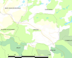
Villeneuve-de-Marc (Villeneuve-de-Marc)

- commune in Isère, France
 Hiking in Villeneuve-de-Marc
Villeneuve-de-Marc is a charming village located in the Auvergne-Rhône-Alpes region of France. It's situated near the Rhône River and offers a picturesque landscape that is perfect for hiking enthusiasts. Here are some details to help you plan a hiking trip in and around Villeneuve-de-Marc:
Hiking Trails
-
Surrounding Countryside: The area around Villeneuve-de-Marc features beautiful rolling hills, forests, and agriculture. You can find a variety of trails that explore the natural beauty of the region. Many trails are moderate, making them suitable for different skill levels.
-
Isère River Trails: The nearby Isère River presents opportunities for scenic hikes along its banks. You can enjoy the river views and perhaps spot some wildlife.
-
Local Nature Parks: Consider visiting nearby natural parks or protected areas. These may offer marked trails that delve deeper into the local flora and fauna, allowing for a more immersive hiking experience.
Recommendations
-
Trail Mapping: Before heading out, it’s advisable to procure a local hiking map or download trail apps that provide GPS support to ensure you don't get lost.
-
Weather Check: Always check the weather forecast before setting out, as conditions can change quickly in the region.
-
Gear Up: Wear sturdy hiking boots and dress in layers, as temperatures can fluctuate. Don’t forget essentials like water, snacks, a first-aid kit, and a fully charged phone.
-
Local Culture: Take time to explore the village itself after your hikes. Villeneuve-de-Marc is rich in local culture and history, and visiting small cafes or local markets can enhance your experience.
Accessibility
Villeneuve-de-Marc is accessible by car, and public transport options may vary. It’s advisable to check local transport options if you are traveling without a vehicle.
Conclusion
Hiking in Villeneuve-de-Marc offers a great mix of natural beauty, tranquility, and an authentic slice of rural France. Whether you're walking along river trails or venturing into the hills, it's a fantastic spot for both casual walkers and more serious hikers. Enjoy your adventure and remember to respect the local environment!
- Country:

- Postal Code: 38440
- Coordinates: 45° 28' 33" N, 5° 6' 8" E


- GPS tracks (wikiloc): [Link]
- Area: 26.18 sq km
- Population: 1140
- Web site: http://www.villeneuvedemarc.fr
- Wikipedia en: wiki(en)
- Wikipedia: wiki(fr)
- Wikidata storage: Wikidata: Q1066646
- Wikipedia Commons Category: [Link]
- Freebase ID: [/m/03nvhzm]
- GeoNames ID: Alt: [6433463]
- SIREN number: [213805559]
- BnF ID: [152583558]
- VIAF ID: Alt: [168826158]
- Library of Congress authority ID: Alt: [n94097221]
- INSEE municipality code: 38555
Shares border with regions:

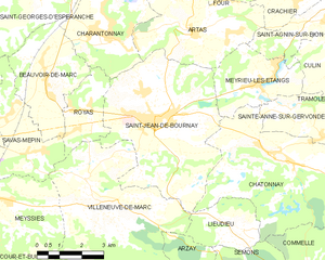
Saint-Jean-de-Bournay
- commune in Isère, France
Hiking in Saint-Jean-de-Bournay
Saint-Jean-de-Bournay is a charming commune located in the Isère department of the Auvergne-Rhône-Alpes region in southeastern France. The surrounding area is characterized by diverse landscapes, including low valleys, rolling hills, and scenic views, making it a great destination for hiking enthusiasts....
- Country:
- Postal Code: 38440
- Coordinates: 45° 30' 8" N, 5° 8' 16" E
- GPS tracks (wikiloc): [Link]
- Area: 26.87 sq km
- Population: 4622
- Web site: [Link]

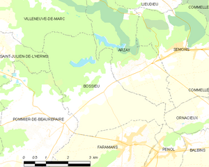
Bossieu
- commune in Isère, France
Hiking in Bossieu
Bossieu, a small commune in the Isère department of southeastern France, offers some charming opportunities for hiking enthusiasts. The region is characterized by its picturesque landscapes, which include rolling hills, forests, and views of the surrounding mountains....
- Country:
- Postal Code: 38260
- Coordinates: 45° 25' 1" N, 5° 8' 53" E
- GPS tracks (wikiloc): [Link]
- Area: 13.48 sq km
- Population: 281
- Web site: [Link]

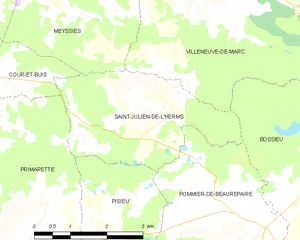
Saint-Julien-de-l'Herms
- commune in Isère, France
Hiking in Saint-Julien-de-l'Herms
Saint-Julien-de-l'Herms is a charming village located in the French Alps, known for its stunning natural landscapes and outdoor recreational opportunities....
- Country:
- Postal Code: 38122
- Coordinates: 45° 25' 57" N, 5° 5' 40" E
- GPS tracks (wikiloc): [Link]
- Area: 9.17 sq km
- Population: 144


Savas-Mépin
- commune in Isère, France
Hiking in Savas-Mépin
Savas-Mépin is a small commune located in the Auvergne-Rhône-Alpes region of southeastern France, known for its scenic natural landscapes and outdoor activities, including hiking. While being less well-known than some major hiking destinations in the Alps or the Vercors region, Savas-Mépin offers a peaceful environment for outdoor enthusiasts....
- Country:
- Postal Code: 38440
- Coordinates: 45° 29' 22" N, 5° 4' 16" E
- GPS tracks (wikiloc): [Link]
- Area: 10.43 sq km
- Population: 869
- Web site: [Link]
Lieudieu
- commune in Isère, France
Hiking in Lieudieu
Lieudieu is a scenic area located in the Auvergne-Rhône-Alpes region of France, nestled in the beautiful landscapes of the Alps. Hiking in this region can offer breathtaking views, diverse terrain, and opportunities to explore both nature and local culture....
- Country:
- Postal Code: 38440
- Coordinates: 45° 27' 30" N, 5° 10' 53" E
- GPS tracks (wikiloc): [Link]
- Area: 5.94 sq km
- Population: 341


Meyssiez
- commune in Isère, France
Hiking in Meyssiez
Meyssiez is a small town located in the Auvergne-Rhône-Alpes region of France, surrounded by beautiful natural landscapes that make it a great spot for hiking enthusiasts. Here are some details about hiking in and around Meyssiez:...
- Country:
- Postal Code: 38440
- Coordinates: 45° 28' 13" N, 5° 3' 15" E
- GPS tracks (wikiloc): [Link]
- Area: 13.88 sq km
- Population: 619

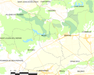
Arzay
- commune in Isère, France
Hiking in Arzay
As of my last update, there's limited information specifically about "Arzay" as a hiking destination. It's possible that you might be referring to a less-known area or there might be a misspelling. However, I can provide general hiking tips and suggestions for exploring regions that might include areas like Arzay if they are situated near popular hiking destinations....
- Country:
- Postal Code: 38260
- Coordinates: 45° 25' 32" N, 5° 10' 13" E
- GPS tracks (wikiloc): [Link]
- Area: 9.79 sq km
- Population: 226

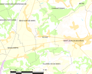
Royas
- commune in Isère, France
Hiking in Royas
Royas is a beautiful yet lesser-known hiking destination, perfect for those looking to explore nature away from the more crowded trails. Although it might not be as famous as other hiking spots, it offers stunning landscapes, diverse wildlife, and a peaceful atmosphere....
- Country:
- Postal Code: 38440
- Coordinates: 45° 30' 21" N, 5° 6' 16" E
- GPS tracks (wikiloc): [Link]
- Area: 5.48 sq km
- Population: 389
- Web site: [Link]