Séderon (Séderon)

- commune in Drôme, France
 Hiking in Séderon
Séderon is a picturesque village located in the Drôme region of southeastern France, known for its stunning landscapes and hiking opportunities. The surrounding area offers a variety of trails that cater to different skill levels and interests, making it an ideal destination for both casual walkers and experienced hikers.
Hiking Highlights in Séderon:
-
Diverse Terrain: The region features a mix of lush valleys, rugged hills, and the nearby Mont Ventoux, providing hikers with diverse landscapes to explore. The trails often lead through forests, across meadows, and along rivers, giving a taste of the region’s natural beauty.
-
Local Trails: Various marked trails start from Séderon, including paths that wind through the Montagne de la Lance. These trails may range from gentle, scenic walks to more challenging hikes that offer stunning views from higher elevations.
-
Heritage and Culture: While hiking, you can discover the local flora and fauna as well as historical sites like ancient ruins and charming Provençal villages scattered throughout the area. The trails often provide opportunities to learn about the region's culture and traditions.
-
Wildlife Watching: The diverse ecosystems in and around Séderon are home to a variety of wildlife, making it a great spot for nature enthusiasts. Keep an eye out for birds, deer, and other wildlife as you explore the trails.
-
Seasonal Hiking: The best times to hike in this region are spring and fall when the weather is mild, and the landscapes are particularly beautiful. However, summer hikes can also be enjoyable, provided you manage the heat.
-
Resources: Before heading out, it’s wise to check local maps and guides available at tourist information centers. You can also find GPS tracks for many trails online, which can be helpful for navigation.
-
Hiking Clubs: If you're looking for a group experience, consider joining a local hiking club. They often organize guided hikes that can enhance your experience and lead you to hidden gems in the area.
Safety Tips:
- Footwear: Wear sturdy hiking boots to navigate the varied terrain comfortably.
- Hydration: Carry enough water, especially during warmer months, as some trails can be quite exposed.
- Weather Awareness: Be aware of the weather conditions, as they can change rapidly, especially in mountainous areas.
- Navigation: Familiarize yourself with the trail maps or GPS before starting your hike.
Overall, Séderon offers an excellent base for exploring the natural beauty of the Drôme region through its network of hiking trails. Whether you seek a peaceful walk or an adventurous trek, you’re sure to find something that suits your preferences.
- Country:

- Postal Code: 26560
- Coordinates: 44° 12' 16" N, 5° 32' 14" E


- GPS tracks (wikiloc): [Link]
- Area: 20.3 sq km
- Population: 272
- Wikipedia en: wiki(en)
- Wikipedia: wiki(fr)
- Wikidata storage: Wikidata: Q219331
- Wikipedia Commons Category: [Link]
- Freebase ID: [/m/03g_hjt]
- GeoNames ID: Alt: [6430245]
- SIREN number: [212603401]
- BnF ID: [15253200h]
- VIAF ID: Alt: [317278388]
- GND ID: Alt: [1076413935]
- WOEID: [621567]
- INSEE municipality code: 26340
Shares border with regions:

Les Omergues
- commune in Alpes-de-Haute-Provence, France
Hiking in Les Omergues
Les Omergues is a charming village located in the Provence-Alpes-Côte d'Azur region of southeastern France. It's surrounded by scenic landscapes that offer excellent hiking opportunities, making it a great destination for outdoor enthusiasts....
- Country:
- Postal Code: 04200
- Coordinates: 44° 10' 18" N, 5° 36' 28" E
- GPS tracks (wikiloc): [Link]
- Area: 34.22 sq km
- Population: 132


Villefranche-le-Château
- commune in Drôme, France
Hiking in Villefranche-le-Château
Villefranche-le-Château, located in the beautiful region of France, offers a variety of hiking opportunities amidst picturesque landscapes. The surrounding areas are characterized by rolling hills, dense forests, and charming rural settings, making it a great destination for outdoor enthusiasts....
- Country:
- Postal Code: 26560
- Coordinates: 44° 13' 16" N, 5° 31' 21" E
- GPS tracks (wikiloc): [Link]
- Area: 7.42 sq km
- Population: 24

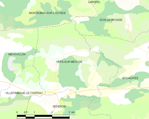
Vers-sur-Méouge
- commune in Drôme, France
Hiking in Vers-sur-Méouge
Vers-sur-Méouge is a charming village located in the Drôme department in southeastern France, known for its natural beauty and outdoor activities, particularly hiking. The surrounding region features stunning landscapes, including the picturesque Méouge River, limestone cliffs, and the scenic backdrop of the Baronnies Provençales Natural Regional Park....
- Country:
- Postal Code: 26560
- Coordinates: 44° 13' 51" N, 5° 34' 14" E
- GPS tracks (wikiloc): [Link]
- Area: 13.81 sq km
- Population: 47


Barret-de-Lioure
- commune in Drôme, France
Hiking in Barret-de-Lioure
Barret-de-Lioure is a picturesque village located in the Drôme department of southeastern France. It is surrounded by stunning natural landscapes that provide excellent opportunities for hiking and outdoor activities. Here are some key points to consider if you're planning a hiking trip in or around Barret-de-Lioure:...
- Country:
- Postal Code: 26570
- Coordinates: 44° 11' 10" N, 5° 29' 37" E
- GPS tracks (wikiloc): [Link]
- Area: 34.64 sq km
- Population: 86

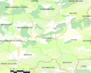
Eygalayes
- commune in Drôme, France
Hiking in Eygalayes
Eygaliers is a picturesque village in the Drôme department of southeastern France, nestled in the beautiful landscape of the Vercors Regional Natural Park. It offers a variety of hiking opportunities that cater to all levels of experience. Here’s a general overview of hiking in the Eygaliers area:...
- Country:
- Postal Code: 26560
- Coordinates: 44° 14' 21" N, 5° 36' 28" E
- GPS tracks (wikiloc): [Link]
- Area: 17.97 sq km
- Population: 76
- Web site: [Link]