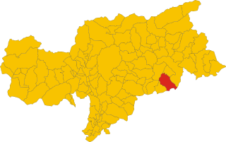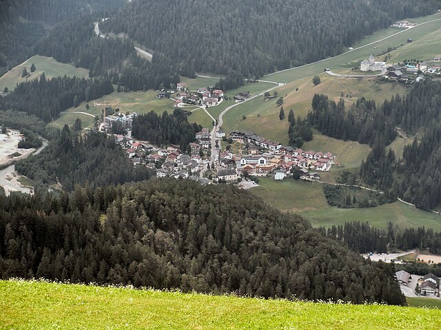
Sëlva (Selva di Val Gardena)
- Italian comune
Sëlva, known as Selva di Val Gardena, is a picturesque village located in the Dolomites of northern Italy, particularly popular for its stunning landscapes and diverse hiking trails. The Dolomites are a UNESCO World Heritage site, making hiking in this region an unforgettable experience.
Hiking Highlights in Sëlva:
-
Scenic Trails: The area offers a range of trails that cater to different skill levels, from easy walks suitable for families to challenging hikes for experienced trekkers. The trails often provide breathtaking views of the iconic Dolomite peaks.
-
Val Gardena Hiking Network: Sëlva is part of the extensive Val Gardena hiking network, featuring over 1,000 kilometers of marked trails. You can explore various routes that connect to neighboring valleys such as Alpe di Siusi and the Sella Pass.
-
The Puez-Odle Nature Park: This protected area surrounds Sëlva and offers some of the most stunning hikes in the Dolomites. Notable trails include the trek to Seceda and the panoramic loop around the Puez plateau.
-
Guided Tours: For those who might want a more structured experience or to learn about the local flora and fauna, guided hikes are available. Local guides can provide insights into the geology, history, and ecosystems of the area.
-
Lifts and Transport: During the summer months, many of the ski lifts operate, allowing hikers to access higher altitudes with ease. This can open up new trail options and reduce the difficulty of some ascents.
-
Cultural Experiences: Hiking in Sëlva also provides an opportunity to experience the rich culture of the Ladin people. Various huts and restaurants along the trails serve traditional cuisine, making for delightful resting spots.
-
Wildlife Watching: Keep an eye out for local wildlife, such as chamois, marmots, and various bird species, as you hike through the diverse ecosystems.
Hiking Tips:
- Best Time to Hike: Late spring to early fall (May to October) is the best time for hiking, as the weather is generally mild and trails are accessible.
- Gear: A good pair of hiking boots, weather-appropriate clothing, and plenty of water and snacks are essential. Trekking poles can also be helpful on steep trails.
- Weather Awareness: The weather can change rapidly in the mountains, so it’s important to check the forecast and be prepared for varying conditions.
- Trail Maps: While many trails are well-marked, having a detailed map or a hiking app can be beneficial for navigation.
Exploring Sëlva and the surrounding Dolomites through hiking offers a wonderful way to connect with nature while experiencing the unique culture and beauty of this remarkable region. Enjoy your hike!
- Country:

- Postal Code: 39048
- Local Dialing Code: 0471
- Licence Plate Code: BZ
- Coordinates: 46° 33' 17" N, 11° 45' 37" E


- GPS tracks (wikiloc): [Link]
- AboveSeaLevel: 1563 м m
- Area: 56.24 sq km
- Population: 2621
- Web site: http://www.comune.selvadivalgardena.bz.it
- Wikipedia en: wiki(en)
- Wikipedia: wiki(it)
- Wikidata storage: Wikidata: Q499129
- Wikipedia Commons Category: [Link]
- Freebase ID: [/m/0g9jx1]
- GeoNames ID: Alt: [6535981]
- VIAF ID: Alt: [246944545]
- OSM relation ID: [47242]
- GND ID: Alt: [4437223-1]
- ISTAT ID: 021089
- Italian cadastre code: I591
Shares border with regions:


Campitello di Fassa
- Italian comune
Campitello di Fassa, located in the Dolomites in northern Italy, is a picturesque destination for hiking enthusiasts. Surrounded by stunning mountain landscapes, lush forests, and vibrant meadows, it offers a variety of trails suitable for hikers of all skill levels....
- Country:

- Postal Code: 38031
- Local Dialing Code: 0462
- Licence Plate Code: TN
- Coordinates: 46° 28' 36" N, 11° 44' 28" E


- GPS tracks (wikiloc): [Link]
- AboveSeaLevel: 1448 м m
- Area: 25.02 sq km
- Population: 730
- Web site: [Link]


Canazei
- Italian comune
Canazei, located in the Trentino-Alto Adige region of northern Italy, is a popular destination for hiking enthusiasts thanks to its stunning Dolomite mountain scenery and extensive network of trails. Here are some key points to consider when planning a hiking trip to Canazei:...
- Country:

- Postal Code: 38032
- Local Dialing Code: 0462
- Licence Plate Code: TN
- Coordinates: 46° 28' 37" N, 11° 46' 16" E


- GPS tracks (wikiloc): [Link]
- AboveSeaLevel: 1842 м m
- Area: 67.3 sq km
- Population: 1829
- Web site: [Link]


Badia
- Italian comune in South Tyrol
Hiking in Badia, located in the heart of South Tyrol, Italy, offers a unique blend of stunning natural landscapes, rich cultural heritage, and a variety of trails suitable for all skill levels. Here are several important aspects of hiking in this beautiful area:...
- Country:

- Postal Code: 39036
- Local Dialing Code: 0471
- Licence Plate Code: BZ
- Coordinates: 46° 36' 40" N, 11° 53' 40" E


- GPS tracks (wikiloc): [Link]
- AboveSeaLevel: 1315 м m
- Area: 83.18 sq km
- Population: 3491
- Web site: [Link]


Corvara
- Italian comune in South Tyrol
Corvara, located in the heart of the Dolomites in South Tyrol, Italy, is a stunning destination for hiking enthusiasts. Surrounded by dramatic mountain peaks, lush valleys, and picturesque meadows, it offers a wide variety of hiking experiences suitable for all skill levels. Here’s an overview of what you can expect when hiking in Corvara:...
- Country:

- Postal Code: 39033
- Local Dialing Code: 0471
- Licence Plate Code: BZ
- Coordinates: 46° 33' 1" N, 11° 52' 24" E


- GPS tracks (wikiloc): [Link]
- AboveSeaLevel: 1568 м m
- Area: 38.92 sq km
- Population: 1372
- Web site: [Link]


San Martin de Tor
- Italian comune
San Martin de Tor, located in the Dolomites of Northern Italy, is an excellent destination for hiking enthusiasts. The area is known for its stunning landscapes, rich cultural heritage, and a variety of trails that cater to different skill levels. Here are some highlights and tips for hiking in and around San Martin de Tor:...
- Country:

- Postal Code: 39030
- Local Dialing Code: 0474
- Licence Plate Code: BZ
- Coordinates: 46° 40' 54" N, 11° 53' 53" E


- GPS tracks (wikiloc): [Link]
- AboveSeaLevel: 1127 м m
- Area: 75.94 sq km
- Population: 1744
- Web site: [Link]


Santa Cristina Gherdëina
- Italian comune
 Hiking in Santa Cristina Gherdëina
Santa Cristina Gherdëina, located in the Dolomites of northern Italy, is a beautiful destination for hiking enthusiasts. The stunning landscape, dramatic peaks, and vibrant alpine scenery provide an incredible backdrop for a variety of hiking trails, suitable for all skill levels. Here are some highlights and tips if you’re considering hiking in this region:...
- Country:

- Postal Code: 39047
- Local Dialing Code: 0471
- Licence Plate Code: BZ
- Coordinates: 46° 33' 47" N, 11° 43' 56" E


- GPS tracks (wikiloc): [Link]
- AboveSeaLevel: 1428 м m
- Area: 31.92 sq km
- Population: 1961
- Web site: [Link]
