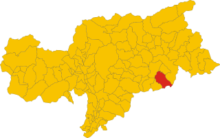
San Martin de Tor (San Martino in Badia)
.svg)
- Italian comune
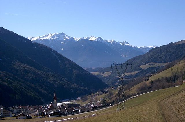
 Hiking in San Martin de Tor
San Martin de Tor, located in the Dolomites of Northern Italy, is an excellent destination for hiking enthusiasts. The area is known for its stunning landscapes, rich cultural heritage, and a variety of trails that cater to different skill levels. Here are some highlights and tips for hiking in and around San Martin de Tor:
Trail Options
-
Easy Trails:
- Many gentle trails suitable for families and beginners can be found in the valley. These often lead through beautiful meadows and forests with breathtaking views of the surrounding peaks.
-
Moderate Trails:
- For more experienced hikers, trails lead up into the hills and mountains, offering more elevation gain and challenging terrain. The trails around the Puez-Odle Nature Park are particularly popular for their stunning views.
-
Difficult Trails:
- Advanced hikers can tackle more demanding routes, including via ferrata (protected climbing routes) or high-altitude trails leading to mountain passes.
Key Attractions
- Puez-Odle Nature Park: A UNESCO World Heritage Site, this park offers numerous hiking opportunities with breathtaking scenery, diverse wildlife, and unique geological formations.
- Lago di Braies: Although slightly further away, this iconic lake is worth a visit for its stunning turquoise waters, surrounded by dramatic mountain scenery.
- Local Culture: Many trails pass through traditional villages, allowing hikers to experience local Ladin culture, architecture, and cuisine.
Best Time to Hike
The best times for hiking in San Martin de Tor are typically late spring to early autumn (May to September). During these months, the weather is generally mild and conducive to hiking, with trails usually free of snow.
Safety Tips
- Weather: Always check the weather forecast before heading out. Mountain weather can change rapidly.
- Equipment: Wear sturdy hiking boots, bring a map or GPS device, and carry essentials such as water, snacks, and a first-aid kit.
- Get Local Advice: Don’t hesitate to stop by local visitor centers or consult with guides for the best trails and tips specific to the area.
Overall, San Martin de Tor offers a plethora of opportunities for hiking, with its breathtaking scenery and well-marked trails making it a fantastic destination for outdoor enthusiasts. Enjoy your adventure!
- Country:

- Postal Code: 39030
- Local Dialing Code: 0474
- Licence Plate Code: BZ
- Coordinates: 46° 40' 54" N, 11° 53' 53" E


- GPS tracks (wikiloc): [Link]
- AboveSeaLevel: 1127 м m
- Area: 75.94 sq km
- Population: 1744
- Web site: http://www.comune.sanmartinoinstrada.lo.it
- Wikipedia en: wiki(en)
- Wikipedia: wiki(it)
- Wikidata storage: Wikidata: Q494793
- Wikipedia Commons Gallery: [Link]
- Wikipedia Commons Category: [Link]
- Freebase ID: [/m/0g9jrl]
- GeoNames ID: Alt: [6536017]
- VIAF ID: Alt: [138485347]
- OSM relation ID: [47276]
- GND ID: Alt: [4528035-6]
- Library of Congress authority ID: Alt: [n88196227]
- ISTAT ID: 021082
- Italian cadastre code: H988
Shares border with regions:


Brixen
- Italian comune
Hiking in Brixen
Brixen, also known as Bressanone, is a charming town located in the South Tyrol region of northern Italy. It's surrounded by the beautiful Dolomites, making it a fantastic destination for hiking enthusiasts. Here are some highlights about hiking in and around Brixen:...
- Country:
- Postal Code: 39042
- Local Dialing Code: 0472
- Licence Plate Code: BZ
- Coordinates: 46° 43' 0" N, 11° 39' 0" E
- GPS tracks (wikiloc): [Link]
- AboveSeaLevel: 560 м m
- Area: 84.7 sq km
- Population: 21688
- Web site: [Link]

Villnöß
- Italian comune
Hiking in Villnöß
Villnöß, or Villnöß Valley, is a beautiful hiking destination located in South Tyrol, Northern Italy. Nestled at the foot of the Dolomites, it offers stunning landscapes, diverse trails, and an opportunity to experience both nature and local culture. Here are some highlights about hiking in this picturesque area:...
- Country:
- Postal Code: 39040
- Local Dialing Code: 0472
- Licence Plate Code: BZ
- Coordinates: 46° 38' 34" N, 11° 40' 42" E
- GPS tracks (wikiloc): [Link]
- AboveSeaLevel: 1132 м m
- Area: 81.38 sq km
- Population: 2603
- Web site: [Link]

Badia
- Italian comune in South Tyrol
Hiking in Badia
Hiking in Badia, located in the heart of South Tyrol, Italy, offers a unique blend of stunning natural landscapes, rich cultural heritage, and a variety of trails suitable for all skill levels. Here are several important aspects of hiking in this beautiful area:...
- Country:
- Postal Code: 39036
- Local Dialing Code: 0471
- Licence Plate Code: BZ
- Coordinates: 46° 36' 40" N, 11° 53' 40" E
- GPS tracks (wikiloc): [Link]
- AboveSeaLevel: 1315 м m
- Area: 83.18 sq km
- Population: 3491
- Web site: [Link]


Corvara
- Italian comune in South Tyrol
Hiking in Corvara
Corvara, located in the heart of the Dolomites in South Tyrol, Italy, is a stunning destination for hiking enthusiasts. Surrounded by dramatic mountain peaks, lush valleys, and picturesque meadows, it offers a wide variety of hiking experiences suitable for all skill levels. Here’s an overview of what you can expect when hiking in Corvara:...
- Country:
- Postal Code: 39033
- Local Dialing Code: 0471
- Licence Plate Code: BZ
- Coordinates: 46° 33' 1" N, 11° 52' 24" E
- GPS tracks (wikiloc): [Link]
- AboveSeaLevel: 1568 м m
- Area: 38.92 sq km
- Population: 1372
- Web site: [Link]


La Val
- comune in Northern Italy
Hiking in La Val
La Val, located in the Dolomites of Northern Italy, is a picturesque destination ideal for hiking enthusiasts. This charming valley is part of the South Tyrol province and is known for its stunning landscapes, rich culture, and a wide array of hiking trails suitable for all levels of experience....
- Country:
- Postal Code: 39030
- Local Dialing Code: 0471
- Licence Plate Code: BZ
- Coordinates: 46° 39' 27" N, 11° 55' 26" E
- GPS tracks (wikiloc): [Link]
- AboveSeaLevel: 1353 м m
- Area: 38.92 sq km
- Population: 1387
- Web site: [Link]

Lüsen
- Italian comune
Hiking in Lüsen
Lüsen, or Lüsen Valley, is a picturesque area located in South Tyrol, Italy, known for its stunning mountain scenery and a variety of hiking trails suitable for all levels of hikers. Situated near the larger town of Brixen (or Bressanone), it is a popular destination for outdoor enthusiasts....
- Country:
- Postal Code: 39040
- Local Dialing Code: 0472
- Licence Plate Code: BZ
- Coordinates: 46° 44' 46" N, 11° 45' 40" E
- GPS tracks (wikiloc): [Link]
- AboveSeaLevel: 962 м m
- Area: 74.41 sq km
- Population: 1545
- Web site: [Link]


Mareo
- Italian comune
Hiking in Mareo
Mareo is a charming area in the Asturias region of northern Spain, known for its breathtaking natural landscapes, rich biodiversity, and traditional villages. Hiking in Mareo can be a rewarding experience, offering various trails that cater to hikers of different skill levels. Here are a few key points to consider if you plan on hiking in this area:...
- Country:
- Postal Code: 39030
- Local Dialing Code: 0474
- Licence Plate Code: BZ
- Coordinates: 46° 43' 8" N, 11° 55' 1" E
- GPS tracks (wikiloc): [Link]
- AboveSeaLevel: 1186 м m
- Area: 160.32 sq km
- Population: 3037
- Web site: [Link]
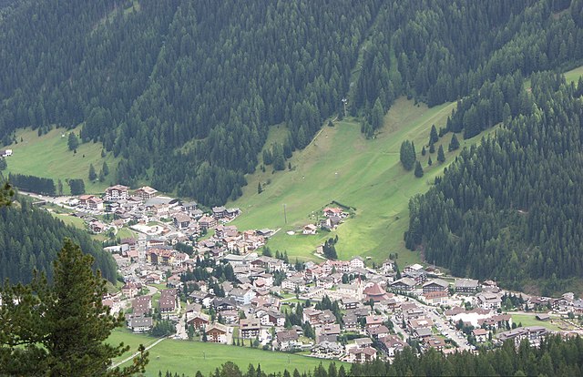

Sëlva
- Italian comune
Hiking in Sëlva
Sëlva, known as Selva di Val Gardena, is a picturesque village located in the Dolomites of northern Italy, particularly popular for its stunning landscapes and diverse hiking trails. The Dolomites are a UNESCO World Heritage site, making hiking in this region an unforgettable experience....
- Country:
- Postal Code: 39048
- Local Dialing Code: 0471
- Licence Plate Code: BZ
- Coordinates: 46° 33' 17" N, 11° 45' 37" E
- GPS tracks (wikiloc): [Link]
- AboveSeaLevel: 1563 м m
- Area: 56.24 sq km
- Population: 2621
- Web site: [Link]


Santa Cristina Gherdëina
- Italian comune
Hiking in Santa Cristina Gherdëina
Santa Cristina Gherdëina, located in the Dolomites of northern Italy, is a beautiful destination for hiking enthusiasts. The stunning landscape, dramatic peaks, and vibrant alpine scenery provide an incredible backdrop for a variety of hiking trails, suitable for all skill levels. Here are some highlights and tips if you’re considering hiking in this region:...
- Country:
- Postal Code: 39047
- Local Dialing Code: 0471
- Licence Plate Code: BZ
- Coordinates: 46° 33' 47" N, 11° 43' 56" E
- GPS tracks (wikiloc): [Link]
- AboveSeaLevel: 1428 м m
- Area: 31.92 sq km
- Population: 1961
- Web site: [Link]