Saint-Denis-de-Cabanne (Saint-Denis-de-Cabanne)

- commune in Loire, France
- Country:

- Postal Code: 42750
- Coordinates: 46° 10' 27" N, 4° 12' 43" E


- GPS tracks (wikiloc): [Link]
- Area: 7.65 sq km
- Population: 1271
- Web site: http://www.saintdenisdecabanne.fr
- Wikipedia en: wiki(en)
- Wikipedia: wiki(fr)
- Wikidata storage: Wikidata: Q680050
- Wikipedia Commons Category: [Link]
- Freebase ID: [/m/03nw89m]
- Freebase ID: [/m/03nw89m]
- GeoNames ID: Alt: [6612536]
- GeoNames ID: Alt: [6612536]
- SIREN number: [214202152]
- SIREN number: [214202152]
- BnF ID: [15259783v]
- BnF ID: [15259783v]
- INSEE municipality code: 42215
- INSEE municipality code: 42215
Shares border with regions:
Mars
- commune in Loire, France
- Country:
- Postal Code: 42750
- Coordinates: 46° 9' 11" N, 4° 14' 47" E
- GPS tracks (wikiloc): [Link]
- AboveSeaLevel: 390 м m
- Area: 12.03 sq km
- Population: 557
Chandon
- commune in Loire, France
- Country:
- Postal Code: 42190
- Coordinates: 46° 8' 59" N, 4° 12' 50" E
- GPS tracks (wikiloc): [Link]
- Area: 12.38 sq km
- Population: 1438


Saint-Edmond
- commune in Saône-et-Loire, France
- Country:
- Postal Code: 71740
- Coordinates: 46° 12' 16" N, 4° 12' 47" E
- GPS tracks (wikiloc): [Link]
- Area: 10.38 sq km
- Population: 372
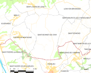
Saint-Bonnet-de-Cray
- commune in Saône-et-Loire, France
- Country:
- Postal Code: 71340
- Coordinates: 46° 12' 54" N, 4° 8' 22" E
- GPS tracks (wikiloc): [Link]
- Area: 22.41 sq km
- Population: 484


Saint-Martin-de-Lixy
- commune in Saône-et-Loire, France
- Country:
- Postal Code: 71740
- Coordinates: 46° 12' 11" N, 4° 14' 45" E
- GPS tracks (wikiloc): [Link]
- Area: 4.19 sq km
- Population: 89


Maizilly
- commune in Loire, France
- Country:
- Postal Code: 42750
- Coordinates: 46° 10' 43" N, 4° 14' 41" E
- GPS tracks (wikiloc): [Link]
- Area: 5.12 sq km
- Population: 335
- Web site: [Link]


Charlieu
- commune in Loire, France
- Country:
- Postal Code: 42190
- Coordinates: 46° 9' 34" N, 4° 10' 19" E
- GPS tracks (wikiloc): [Link]
- AboveSeaLevel: 265 м m
- Area: 6.7 sq km
- Population: 3694
- Web site: [Link]