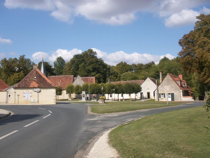
Saint-Lactencin (Saint-Lactencin)

- commune in Indre, France
- Country:

- Postal Code: 36500
- Coordinates: 46° 53' 53" N, 1° 29' 35" E


- GPS tracks (wikiloc): [Link]
- AboveSeaLevel: 149 м m
- Area: 32.2 sq km
- Population: 430
- Wikipedia en: wiki(en)
- Wikipedia: wiki(fr)
- Wikidata storage: Wikidata: Q925651
- Wikipedia Commons Category: [Link]
- Freebase ID: [/m/03nv9j0]
- GeoNames ID: Alt: [6432976]
- SIREN number: [213601982]
- BnF ID: [152575020]
- PACTOLS thesaurus ID: [pcrt0QhWhU48rp]
- INSEE municipality code: 36198
Shares border with regions:
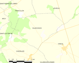
Villegongis
- commune in Indre, France
- Country:
- Postal Code: 36110
- Coordinates: 46° 54' 48" N, 1° 35' 44" E
- GPS tracks (wikiloc): [Link]
- Area: 18.15 sq km
- Population: 121
- Web site: [Link]


Chezelles
- commune in Indre, France
- Country:
- Postal Code: 36500
- Coordinates: 46° 53' 24" N, 1° 34' 33" E
- GPS tracks (wikiloc): [Link]
- Area: 17.32 sq km
- Population: 478


Argy
- commune in Indre, France
- Country:
- Postal Code: 36500
- Coordinates: 46° 56' 21" N, 1° 26' 18" E
- GPS tracks (wikiloc): [Link]
- Area: 38.89 sq km
- Population: 612

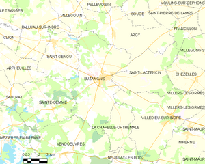
Buzançais
- commune in Indre, France
- Country:
- Postal Code: 36500
- Coordinates: 46° 53' 24" N, 1° 25' 21" E
- GPS tracks (wikiloc): [Link]
- Area: 58.64 sq km
- Population: 4473
- Web site: [Link]

Villedieu-sur-Indre
- commune in Indre, France
- Country:
- Postal Code: 36320
- Coordinates: 46° 50' 47" N, 1° 32' 24" E
- GPS tracks (wikiloc): [Link]
- AboveSeaLevel: 150 м m
- Area: 57.77 sq km
- Population: 2745
- Web site: [Link]


Francillon
- commune in Indre, France
- Country:
- Postal Code: 36110
- Coordinates: 46° 56' 30" N, 1° 33' 43" E
- GPS tracks (wikiloc): [Link]
- Area: 10.27 sq km
- Population: 75