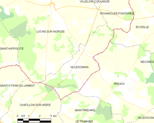
Saint-Médard (Saint-Médard)
- commune in Indre, France
- Country:

- Postal Code: 36700
- Coordinates: 46° 59' 59" N, 1° 14' 48" E


- GPS tracks (wikiloc): [Link]
- Area: 12.6 sq km
- Population: 44
- Web site: http://www.saint-medard-indre.fr
- Wikipedia en: wiki(en)
- Wikipedia: wiki(fr)
- Wikidata storage: Wikidata: Q1137196
- Wikipedia Commons Category: [Link]
- Freebase ID: [/m/03nw4h2]
- GeoNames ID: Alt: [6432980]
- SIREN number: [213602030]
- BnF ID: [15257507q]
- INSEE municipality code: 36203
Shares border with regions:
Le Tranger
- commune in Indre, France
- Country:

- Postal Code: 36700
- Coordinates: 46° 57' 25" N, 1° 14' 25" E


- GPS tracks (wikiloc): [Link]
- Area: 22.26 sq km
- Population: 163


Châtillon-sur-Indre
- commune in Indre, France
- Country:

- Postal Code: 36700
- Coordinates: 46° 59' 16" N, 1° 10' 25" E


- GPS tracks (wikiloc): [Link]
- Area: 45.3 sq km
- Population: 2681
- Web site: [Link]


Préaux
- commune in Indre, France
- Country:

- Postal Code: 36240
- Coordinates: 47° 1' 16" N, 1° 17' 33" E


- GPS tracks (wikiloc): [Link]
- Area: 32.54 sq km
- Population: 161
- Web site: [Link]


Villedômain
- commune in Indre-et-Loire, France
- Country:

- Postal Code: 37110
- Coordinates: 47° 3' 10" N, 1° 15' 21" E


- GPS tracks (wikiloc): [Link]
- Area: 16.47 sq km
- Population: 118
- Web site: [Link]


Palluau-sur-Indre
- commune in Indre, France
- Country:

- Postal Code: 36500
- Coordinates: 46° 56' 38" N, 1° 18' 42" E


- GPS tracks (wikiloc): [Link]
- Area: 41.55 sq km
- Population: 772
- Web site: [Link]
