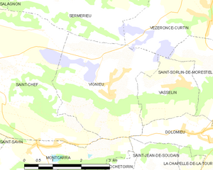
Montcarra (Montcarra)

- commune in Isère, France
 Hiking in Montcarra
Montcarra, located in the Isère department of southeastern France, is a beautiful area known for its scenic landscapes and outdoor activities. While it may not be as widely recognized as some of the larger national parks in the Alps, it offers a variety of hiking opportunities that can cater to different skill levels and preferences.
Hiking Opportunities:
-
Trail Options: There are numerous trails in and around Montcarra, ranging from easy walks to more challenging hikes. These trails often meander through lush forests, alongside rivers, and up hills, providing stunning views of the surrounding countryside and the Alps.
-
Nature and Scenery: The area is renowned for its natural beauty, including diverse flora and fauna. As you hike, you may encounter beautiful wildflowers, birds, and perhaps even some wildlife.
-
Local Culture: Hiking in Montcarra allows trekkers to experience the local culture. Many trails may lead to quaint villages where you can enjoy local cuisine and learn about the history of the region.
-
Seasonal Considerations: The best time to hike in Montcarra is typically during the spring and fall when the weather is mild, and the landscapes are particularly vibrant. Summer can be warm but is also a popular time for hiking, whereas winter may present snow-covered trails suitable for snowshoeing or winter hiking.
-
Safety and Preparation: As with any hiking adventure, it’s important to prepare adequately. Bring plenty of water, layer your clothing for changing weather conditions, and inform someone of your hiking plans. Always check local trail conditions and maps before heading out, as some trails may vary in difficulty and accessibility.
-
Guided Hikes: If you're unfamiliar with the area or prefer guided experiences, consider joining a local hiking group or hiring an instructor who knows the terrain.
Whether you're looking for a peaceful day hike or a more adventurous expedition, Montcarra offers a lovely retreat for hikers seeking to explore the natural beauty of the French countryside.
- Country:

- Postal Code: 38890
- Coordinates: 45° 36' 47" N, 5° 23' 29" E


- GPS tracks (wikiloc): [Link]
- Area: 4.9 sq km
- Population: 519
- Web site: http://www.montcarra.fr
- Wikipedia en: wiki(en)
- Wikipedia: wiki(fr)
- Wikidata storage: Wikidata: Q1068970
- Wikipedia Commons Category: [Link]
- Freebase ID: [/m/03nvgmn]
- GeoNames ID: Alt: [6433252]
- SIREN number: [213802507]
- BnF ID: [15258062q]
- INSEE municipality code: 38250
Shares border with regions:

Vignieu
- commune in Isère, France
Hiking in Vignieu
Vignieu is a charming commune located in the Isère department in the Auvergne-Rhône-Alpes region of southeastern France. While it might not be as well-known as some other hiking destinations in France, it offers picturesque landscapes and a range of outdoor activities that can cater to hikers of various skill levels....
- Country:
- Postal Code: 38890
- Coordinates: 45° 37' 41" N, 5° 25' 29" E
- GPS tracks (wikiloc): [Link]
- Area: 9.4 sq km
- Population: 1033
- Web site: [Link]


Saint-Savin
- commune in Isère, France
Hiking in Saint-Savin
Saint-Savin, located in the Isère department of the Auvergne-Rhône-Alpes region of France, is a charming village known for its natural beauty and access to various hiking trails. The area features stunning landscapes, rolling hills, and proximity to the Chartreuse and Vercors mountain ranges, making it a great destination for outdoor enthusiasts....
- Country:
- Postal Code: 38300
- Coordinates: 45° 37' 43" N, 5° 18' 22" E
- GPS tracks (wikiloc): [Link]
- Area: 24.55 sq km
- Population: 3967
- Web site: [Link]
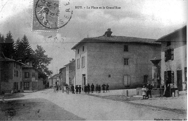

Ruy-Montceau
- commune in Isère, France
Hiking in Ruy-Montceau
Ruy, located in the Isère department of southeastern France, is a charming area that offers a variety of hiking opportunities, taking advantage of the beautiful natural landscapes of the region. Although Ruy itself may not be as widely recognized for hiking as some other areas in the Alps, it's conveniently located near various trails and natural parks that are ideal for outdoor enthusiasts....
- Country:
- Postal Code: 38300
- Coordinates: 45° 35' 18" N, 5° 19' 4" E
- GPS tracks (wikiloc): [Link]
- Area: 20.81 sq km
- Population: 4434
- Web site: [Link]


Saint-Jean-de-Soudain
- commune in Isère, France
Hiking in Saint-Jean-de-Soudain
Saint-Jean-de-Soudain is a picturesque village located in the Isère department of the Auvergne-Rhône-Alpes region in southeastern France. It's an excellent base for hikers looking to explore the natural landscapes and mountainous terrain nearby....
- Country:
- Postal Code: 38110
- Coordinates: 45° 34' 21" N, 5° 25' 44" E
- GPS tracks (wikiloc): [Link]
- Area: 7.48 sq km
- Population: 1572
- Web site: [Link]

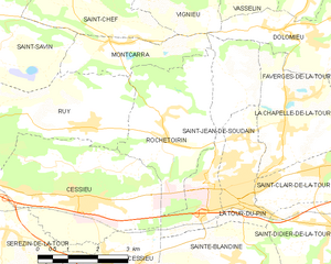
Rochetoirin
- commune in Isère, France
Hiking in Rochetoirin
Rochetoirin, located in the Auvergne-Rhône-Alpes region of France, is a charming destination for hiking enthusiasts. Nestled near the foothills of the Chartreuse Mountains, the area offers a variety of natural landscapes, from rolling hills to picturesque forests, and a glimpse of local flora and fauna....
- Country:
- Postal Code: 38110
- Coordinates: 45° 34' 54" N, 5° 25' 5" E
- GPS tracks (wikiloc): [Link]
- Area: 10.62 sq km
- Population: 1115
- Web site: [Link]


Saint-Chef
- commune in Isère, France
Hiking in Saint-Chef
Saint-Chef is a charming commune located in the Isère department of the Auvergne-Rhône-Alpes region in southeastern France. The area is known for its beautiful landscapes, rolling hills, and rich natural surroundings, making it an attractive destination for hikers of all levels....
- Country:
- Postal Code: 38890
- Coordinates: 45° 38' 2" N, 5° 21' 57" E
- GPS tracks (wikiloc): [Link]
- Area: 27.16 sq km
- Population: 3620
- Web site: [Link]