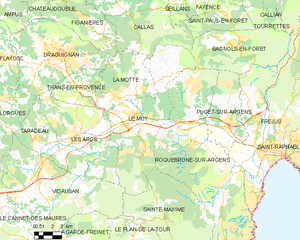
Sainte-Maxime (Sainte-Maxime)
- commune in Var, France
- Country:

- Postal Code: 83120
- Coordinates: 43° 18' 32" N, 6° 38' 16" E


- GPS tracks (wikiloc): [Link]
- Area: 81.61 sq km
- Population: 14289
- Web site: http://www.ville-sainte-maxime.fr/index2.htm
- Wikipedia en: wiki(en)
- Wikipedia: wiki(fr)
- Wikidata storage: Wikidata: Q693017
- Wikipedia Commons Category: [Link]
- Freebase ID: [/m/0g6r1n]
- GeoNames ID: Alt: [2980402]
- SIREN number: [218301158]
- BnF ID: [15277942r]
- VIAF ID: Alt: [158912988]
- GND ID: Alt: [4618179-9]
- Library of Congress authority ID: Alt: [n82118597]
- PACTOLS thesaurus ID: [pcrtlOkxb8Rl8v]
- INSEE municipality code: 83115
- US National Archives Identifier: 10037943
Shares border with regions:


Vidauban
- commune in Var, France
Vidauban is a charming village located in the Var department of the Provence-Alpes-Côte d'Azur region in southeastern France. Surrounded by beautiful landscapes, it offers a variety of hiking opportunities that cater to different skill levels. Here are some highlights and tips for hiking in Vidauban:...
- Country:

- Postal Code: 83550
- Coordinates: 43° 25' 38" N, 6° 25' 55" E


- GPS tracks (wikiloc): [Link]
- Area: 73.93 sq km
- Population: 11391


Roquebrune-sur-Argens
- commune in Var, France
- Country:

- Postal Code: 83520
- Coordinates: 43° 26' 36" N, 6° 38' 16" E


- GPS tracks (wikiloc): [Link]
- Area: 106.1 sq km
- Population: 13195
- Web site: [Link]


Grimaud
- commune in Var, France
- Country:

- Postal Code: 83310
- Coordinates: 43° 16' 24" N, 6° 31' 18" E


- GPS tracks (wikiloc): [Link]
- Area: 44.58 sq km
- Population: 4300


Le Plan-de-la-Tour
- commune in Var, France
- Country:

- Postal Code: 83120
- Coordinates: 43° 20' 26" N, 6° 32' 47" E


- GPS tracks (wikiloc): [Link]
- Area: 36.8 sq km
- Population: 2695
- Web site: [Link]


Le Muy
- commune in Var, France
Le Muy, located in the Var department of the Provence-Alpes-Côte d'Azur region in France, is a fantastic spot for hiking enthusiasts. The area is characterized by its stunning natural scenery, including hills, forests, rivers, and vineyards, making it an ideal place for outdoor activities....
- Country:

- Postal Code: 83490
- Coordinates: 43° 28' 21" N, 6° 33' 59" E


- GPS tracks (wikiloc): [Link]
- Area: 66.58 sq km
- Population: 9361

