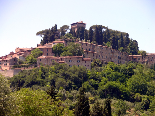
Sarteano (Sarteano)
.svg)
- Italian comune
 Hiking in Sarteano
Sarteano is a charming town located in the Valdichiana area of Tuscany, Italy. Known for its stunning landscapes, medieval architecture, and rich history, Sarteano is an excellent base for hiking enthusiasts looking to explore the picturesque Tuscan countryside.
Hiking Trails in Sarteano:
-
Monti di Sarteano: This area offers several trails that traverse the beautiful hills surrounding the town. The Appennines nearby provide more challenging hikes with stunning panoramic views.
-
Sentiero della Bonifica: This trail runs along the old waterways in the region and offers a relatively flat terrain ideal for leisurely hikes. It's perfect for those who want to enjoy nature without strenuous climbing.
-
Via Francigena: Parts of this historic pilgrimage path pass through the region. Hiking along the Via Francigena allows you to absorb both the natural beauty and the cultural heritage of the area as you walk through ancient villages, vineyards, and olive groves.
-
Parco Archeologico di Belverde: Explore the ancient remains in this archaeological park, where trails take you through historic sites in a natural setting. This combines hiking with a touch of history.
Hiking Tips:
-
Best Time to Hike: Spring (April to June) and fall (September to October) are ideal, with mild temperatures and stunning views as the landscape changes colors.
-
Trail Information: Make sure to check local maps and guides for updated trail conditions and advice on difficulty levels suitable for your experience.
-
What to Bring: Always carry water, hiking poles (if needed), snacks, a first-aid kit, and a fully charged mobile phone. A camera is also recommended, as the scenery is breathtaking!
-
Respect the Environment: Stay on marked trails, avoid littering, and respect local wildlife and plants.
-
Local Guides: If you're new to hiking or want to explore off the beaten path, consider hiring a local guide who can share insights about the flora, fauna, and history of the area.
Hiking in Sarteano offers a fantastic way to experience the natural beauty and cultural richness of Tuscany. Whether you are an experienced hiker or a beginner, there's something for everyone to enjoy amidst the serene landscapes of this lovely region.
- Country:

- Postal Code: 53047
- Local Dialing Code: 0578
- Licence Plate Code: SI
- Coordinates: 42° 59' 0" N, 11° 52' 0" E


- GPS tracks (wikiloc): [Link]
- AboveSeaLevel: 525 м m
- Area: 84.81 sq km
- Population: 4705
- Web site: http://www.comune.sarteano.siena.it
- Wikipedia en: wiki(en)
- Wikipedia: wiki(it)
- Wikidata storage: Wikidata: Q91447
- Wikipedia Commons Category: [Link]
- Freebase ID: [/m/0gm12_]
- GeoNames ID: Alt: [6538604]
- VIAF ID: Alt: [123601652]
- OSM relation ID: [42233]
- GND ID: Alt: [4534296-9]
- TGN ID: [7006335]
- UN/LOCODE: [ITSA2]
- Digital Atlas of the Roman Empire ID: [18722]
- ISTAT ID: 052031
- Italian cadastre code: I445
Shares border with regions:

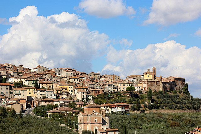
Cetona
- Italian comune
Hiking in Cetona
Cetona is a beautiful town located in the Tuscany region of Italy, known for its stunning landscapes and rich history. The area surrounding Cetona offers several hiking opportunities that cater to different skill levels, making it a great destination for outdoor enthusiasts....
- Country:
- Postal Code: 53040
- Local Dialing Code: 0578
- Licence Plate Code: SI
- Coordinates: 42° 58' 0" N, 11° 54' 0" E
- GPS tracks (wikiloc): [Link]
- AboveSeaLevel: 350 м m
- Area: 53.57 sq km
- Population: 2678
- Web site: [Link]

Chianciano Terme
- Italian comune
Hiking in Chianciano Terme
Chianciano Terme is a charming town in the Tuscany region of Italy, known primarily for its thermal spas, but it also offers beautiful hiking opportunities in the surrounding countryside. Here's an overview of what you can expect when hiking in and around Chianciano Terme:...
- Country:
- Postal Code: 53042
- Local Dialing Code: 0578
- Licence Plate Code: SI
- Coordinates: 43° 4' 0" N, 11° 50' 0" E
- GPS tracks (wikiloc): [Link]
- AboveSeaLevel: 475 м m
- Area: 36.58 sq km
- Population: 7050
- Web site: [Link]

Chiusi
- Italian comune
Hiking in Chiusi
Chiusi, a charming town in the Tuscany region of Italy, is not only rich in history and culture but also offers some beautiful hiking opportunities. Nestled in the rolling hills and surrounded by picturesque landscapes, Chiusi serves as an excellent base for exploring the natural beauty of the area. Here are some highlights and tips for hiking in and around Chiusi:...
- Country:
- Postal Code: 53043
- Local Dialing Code: 0578
- Licence Plate Code: SI
- Coordinates: 43° 1' 0" N, 11° 57' 0" E
- GPS tracks (wikiloc): [Link]
- AboveSeaLevel: 398 м m
- Area: 58.15 sq km
- Population: 8558
- Web site: [Link]


Pienza
- Italian comune
Hiking in Pienza
Pienza, located in the beautiful Tuscany region of Italy, is a charming town known for its stunning landscapes, Renaissance architecture, and rich cultural heritage. It's also surrounded by some fantastic hiking opportunities that showcase the scenic beauty of the Val d'Orcia region. Here are some important aspects to consider when hiking in and around Pienza:...
- Country:
- Postal Code: 53026
- Local Dialing Code: 0578
- Licence Plate Code: SI
- Coordinates: 43° 4' 43" N, 11° 40' 44" E
- GPS tracks (wikiloc): [Link]
- AboveSeaLevel: 491 м m
- Area: 122.96 sq km
- Population: 2082
- Web site: [Link]


Radicofani
- Italian comune
Hiking in Radicofani
Radicofani is a charming village in Tuscany, Italy, known for its stunning landscapes, historical significance, and opportunities for hiking. Located near the border of Lazio, it sits atop a hill, offering sweeping views of the surrounding valleys and the nearby Orcia Valley, which is a UNESCO World Heritage site....
- Country:
- Postal Code: 53040
- Local Dialing Code: 0578
- Licence Plate Code: SI
- Coordinates: 42° 54' 0" N, 11° 46' 0" E
- GPS tracks (wikiloc): [Link]
- AboveSeaLevel: 780 м m
- Area: 118.1 sq km
- Population: 1073
- Web site: [Link]


San Casciano dei Bagni
- Italian comune
Hiking in San Casciano dei Bagni
San Casciano dei Bagni, located in the stunning region of Tuscany, Italy, is not only known for its relaxing thermal baths but also for its beautiful hiking opportunities. The surrounding landscape is characterized by rolling hills, charming vineyards, olive groves, and the picturesque Val d'Orcia. Here’s a guide to hiking in this picturesque area:...
- Country:
- Postal Code: 53040
- Local Dialing Code: 0578
- Licence Plate Code: SI
- Coordinates: 42° 52' 0" N, 11° 53' 0" E
- GPS tracks (wikiloc): [Link]
- AboveSeaLevel: 582 м m
- Area: 92.14 sq km
- Population: 1601
- Web site: [Link]