Savines-le-Lac (Savines-le-Lac)
- commune in Hautes-Alpes, France
 Hiking in Savines-le-Lac
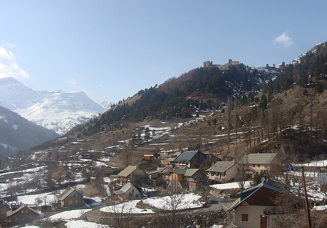
Savines-le-Lac is a picturesque village located in the French Alps, near the Serre-Ponçon Lake in the Hautes-Alpes region. It's an excellent destination for hiking enthusiasts, offering a variety of trails that cater to different skill levels, with stunning views of the lake and surrounding mountains.
Hiking Trails
-
Lac de Serre-Ponçon Loop: A relatively easy trail that takes you around the beautiful Lake Serre-Ponçon. This walk offers scenic views and is great for families.
-
Les Coussouls Trail: This moderate hike takes you through beautiful landscapes and offers panoramic views of the lake and surrounding valleys. It's ideal for hikers looking for a challenge while still enjoying the natural beauty.
-
Le Queyrellin: A more demanding hike that ascends to higher elevations, providing breathtaking views of the Alps. This trail is suited for experienced hikers, with some steep sections and varied terrain.
-
Sentier des Mésanges: This shorter, family-friendly trail is great for beginners and offers interpretative signs about the local flora and fauna.
Best Season to Hike
The best time for hiking in Savines-le-Lac is from late spring (May) to early autumn (September) when the weather is milder and the trails are generally more accessible. Summer months are ideal for discovering the full beauty of the region, but it can be busy with tourists.
Safety Tips
- Weather Check: Always check the weather forecast before heading out, as conditions can change rapidly in the mountains.
- Gear Up: Wear appropriate hiking gear, including sturdy boots, and carry enough water and snacks.
- Navigation: Use a map or GPS device. While most trails are marked, it’s always good to have a backup.
- Local Guidelines: Follow any local guidelines and respect nature by sticking to marked trails.
Points of Interest
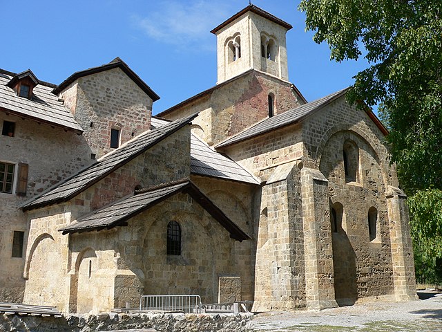
While hiking, take time to appreciate the diverse wildlife, charming alpine villages, and the unique geological formations of the area. You can also explore cultural sites, such as the Church of Savines-le-Lac, which is a beautiful architectural landmark.
Overall, Savines-le-Lac is a great destination for hikers of all levels, with its blend of natural beauty and outdoor adventure opportunities!
- Country:

- Postal Code: 05160
- Coordinates: 44° 31' 33" N, 6° 24' 18" E


- GPS tracks (wikiloc): [Link]
- AboveSeaLevel: 790 м m
- Area: 25.13 sq km
- Population: 1063
- Web site: http://www.savines-le-lac.fr
- Wikipedia en: wiki(en)
- Wikipedia: wiki(fr)
- Wikidata storage: Wikidata: Q1020736
- Wikipedia Commons Category: [Link]
- Freebase ID: [/m/03mfnr9]
- Freebase ID: [/m/03mfnr9]
- GeoNames ID: Alt: [2975522]
- GeoNames ID: Alt: [2975522]
- SIREN number: [210501649]
- SIREN number: [210501649]
- BnF ID: [12202656j]
- BnF ID: [12202656j]
- VIAF ID: Alt: [145563466]
- VIAF ID: Alt: [145563466]
- Library of Congress authority ID: Alt: [n92107819]
- Library of Congress authority ID: Alt: [n92107819]
- INSEE municipality code: 05164
- INSEE municipality code: 05164
- US National Archives Identifier: 10037957
- US National Archives Identifier: 10037957
Shares border with regions:
Crots
- commune in Hautes-Alpes, France
Hiking in Crots
Crots, located in the French Alps within the Hautes-Alpes department, is a beautiful destination for hiking enthusiasts. The area is known for its stunning landscapes, including mountains, valleys, and picturesque villages. If you're planning a hiking trip in Crots, here are some key points to consider:...
- Country:
- Postal Code: 05200
- Coordinates: 44° 32' 1" N, 6° 28' 16" E
- GPS tracks (wikiloc): [Link]
- AboveSeaLevel: 790 м m
- Area: 53.84 sq km
- Population: 1022
Réallon
- commune in Hautes-Alpes, France
Hiking in Réallon
Réallon is a picturesque village located in the French Alps, particularly in the Hautes-Alpes department. It’s a fantastic destination for hiking enthusiasts, offering a mix of stunning landscapes, diverse trails, and breathtaking views of the surrounding mountains and lakes. Here are some key details to consider when hiking in Réallon:...
- Country:
- Postal Code: 05160
- Coordinates: 44° 35' 44" N, 6° 21' 53" E
- GPS tracks (wikiloc): [Link]
- Area: 71.4 sq km
- Population: 260
- Web site: [Link]

Prunières
- commune in Hautes-Alpes, France
Hiking in Prunières
Hiking in Prunières, located in the Hautes-Alpes region of France, offers stunning landscapes and a variety of trails suitable for all levels of hikers. This area is known for its beautiful mountains, alpine meadows, and pristine nature, making it an ideal destination for outdoor enthusiasts....
- Country:
- Postal Code: 05230
- Coordinates: 44° 32' 31" N, 6° 20' 0" E
- GPS tracks (wikiloc): [Link]
- Area: 13.2 sq km
- Population: 298
- Web site: [Link]

Puy-Sanières
- commune in Hautes-Alpes, France
Hiking in Puy-Sanières
Puy-Sanières is a charming village located in the Hautes-Alpes region of France and offers stunning hiking opportunities in the surrounding areas. The region is characterized by its beautiful landscapes, including mountains, plateaus, and valleys, making it a great destination for outdoor enthusiasts....
- Country:
- Postal Code: 05200
- Coordinates: 44° 33' 29" N, 6° 26' 3" E
- GPS tracks (wikiloc): [Link]
- Area: 11.38 sq km
- Population: 257

Saint-Apollinaire
- commune in Hautes-Alpes, France
Hiking in Saint-Apollinaire
Saint-Apollinaire is a charming commune in the Hautes-Alpes department of France, renowned for its stunning natural landscapes and proximity to the French Alps. Hiking in this region offers a variety of trails suitable for different skill levels, providing opportunities to explore diverse terrains, from lush valleys to rocky mountain paths....
- Country:
- Postal Code: 05160
- Coordinates: 44° 33' 22" N, 6° 21' 44" E
- GPS tracks (wikiloc): [Link]
- Area: 7.54 sq km
- Population: 138

Pontis
- commune in Alpes-de-Haute-Provence, France
Hiking in Pontis
Pontis, located in the Alpes-de-Haute-Provence region of France, is a hidden gem for hiking enthusiasts. This picturesque village is surrounded by stunning natural landscapes, offering a range of trails for all levels of hikers....
- Country:
- Postal Code: 05160
- Coordinates: 44° 30' 15" N, 6° 21' 28" E
- GPS tracks (wikiloc): [Link]
- Area: 14.11 sq km
- Population: 85
- Web site: [Link]

Puy-Saint-Eusèbe
- commune in Hautes-Alpes, France
Hiking in Puy-Saint-Eusèbe
Puy-Saint-Eusèbe is a charming destination for hiking enthusiasts, nestled in the region of Auvergne-Rhône-Alpes in southeastern France. The area is known for its stunning landscapes, characterized by rolling hills, deep valleys, and picturesque views of the surrounding mountains....
- Country:
- Postal Code: 05200
- Coordinates: 44° 34' 4" N, 6° 24' 4" E
- GPS tracks (wikiloc): [Link]
- Area: 11.31 sq km
- Population: 137