Crots (Crots)
- commune in Hautes-Alpes, France
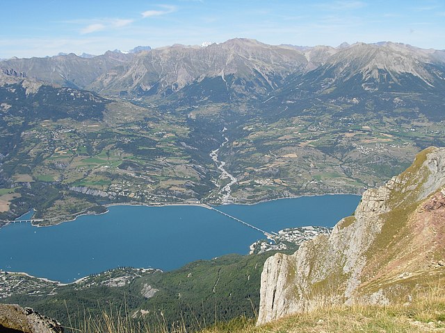
 Hiking in Crots
Crots, located in the French Alps within the Hautes-Alpes department, is a beautiful destination for hiking enthusiasts. The area is known for its stunning landscapes, including mountains, valleys, and picturesque villages. If you're planning a hiking trip in Crots, here are some key points to consider:
Popular Hiking Trails
- Lac de Serre-Ponçon: The trails around the lake offer breathtaking views and a variety of difficulty levels. The circuit around the lake is relatively easy and suitable for families.
- Le Pont de l’Artuby: This trail leads you to spectacular views and is often less crowded, providing a serene hiking experience.
- Col de la Gardette: A more challenging hike for seasoned trekkers, this route offers panoramic views of the surrounding mountains and valleys.
Tips for Hiking in Crots
- Weather: Always check the weather forecast before heading out, as conditions can change rapidly in the mountains.
- Gear: Wear appropriate hiking boots and comfortable clothing. Carry a daypack with essentials such as water, snacks, a map, a first aid kit, and sun protection.
- Local Regulations: Respect nature and follow local guidelines, particularly in protected areas.
- Safety: Inform someone about your hiking route and expected return time, especially if you plan to hike alone.
Best Time to Hike
The hiking season typically begins in late spring (May) and runs through early autumn (October), with summer being the most popular time due to favorable weather conditions.
Accessibility
Crots is accessible by car and is well-connected to nearby towns. Public transport options may be limited, so planning ahead is essential if you do not have a private vehicle.
Local Attractions
In addition to hiking, Crots is near Serre-Ponçon Lake, where you can enjoy activities such as kayaking, fishing, and swimming. The village itself offers charming architecture and local cuisine, perfect for relaxing after a long hike.
Whether you're an experienced hiker or a beginner, Crots provides a variety of trails and stunning scenery that can cater to any hiking enthusiast’s needs. Enjoy your adventure in the French Alps!
- Country:

- Postal Code: 05200
- Coordinates: 44° 32' 1" N, 6° 28' 16" E


- GPS tracks (wikiloc): [Link]
- AboveSeaLevel: 790 м m
- Area: 53.84 sq km
- Population: 1022
- Wikipedia en: wiki(en)
- Wikipedia: wiki(fr)
- Wikidata storage: Wikidata: Q1016429
- Wikipedia Commons Category: [Link]
- Freebase ID: [/m/03mfl91]
- Freebase ID: [/m/03mfl91]
- GeoNames ID: Alt: [3001268]
- GeoNames ID: Alt: [3001268]
- SIREN number: [210500450]
- SIREN number: [210500450]
- BnF ID: [120107686]
- BnF ID: [120107686]
- PACTOLS thesaurus ID: [pcrtK2hNy1WN7j]
- PACTOLS thesaurus ID: [pcrtK2hNy1WN7j]
- INSEE municipality code: 05045
- INSEE municipality code: 05045
Shares border with regions:

Méolans-Revel
- commune in Alpes-de-Haute-Provence, France
Hiking in Méolans-Revel
Méolans-Revel is a charming commune located in the Alpes-de-Haute-Provence region of southeastern France, known for its beautiful landscapes and outdoor recreational opportunities. Here’s an overview of hiking in this area:...
- Country:
- Postal Code: 04340
- Coordinates: 44° 24' 5" N, 6° 30' 42" E
- GPS tracks (wikiloc): [Link]
- AboveSeaLevel: 1040 м m
- Area: 127.74 sq km
- Population: 337
Savines-le-Lac
- commune in Hautes-Alpes, France
Hiking in Savines-le-Lac
Savines-le-Lac is a picturesque village located in the French Alps, near the Serre-Ponçon Lake in the Hautes-Alpes region. It's an excellent destination for hiking enthusiasts, offering a variety of trails that cater to different skill levels, with stunning views of the lake and surrounding mountains....
- Country:
- Postal Code: 05160
- Coordinates: 44° 31' 33" N, 6° 24' 18" E
- GPS tracks (wikiloc): [Link]
- AboveSeaLevel: 790 м m
- Area: 25.13 sq km
- Population: 1063
- Web site: [Link]

Les Orres
- commune in Hautes-Alpes, France
Hiking in Les Orres
Les Orres, located in the French Alps, is a fantastic destination for hiking enthusiasts. This charming mountain resort offers a variety of trails suitable for all levels, from beginners to experienced hikers. Here’s an overview to help you plan your hiking experience in Les Orres:...
- Country:
- Postal Code: 05200
- Coordinates: 44° 30' 50" N, 6° 33' 3" E
- GPS tracks (wikiloc): [Link]
- AboveSeaLevel: 1460 м m
- Area: 74.79 sq km
- Population: 569
- Web site: [Link]

Puy-Sanières
- commune in Hautes-Alpes, France
Hiking in Puy-Sanières
Puy-Sanières is a charming village located in the Hautes-Alpes region of France and offers stunning hiking opportunities in the surrounding areas. The region is characterized by its beautiful landscapes, including mountains, plateaus, and valleys, making it a great destination for outdoor enthusiasts....
- Country:
- Postal Code: 05200
- Coordinates: 44° 33' 29" N, 6° 26' 3" E
- GPS tracks (wikiloc): [Link]
- Area: 11.38 sq km
- Population: 257

Pontis
- commune in Alpes-de-Haute-Provence, France
Hiking in Pontis
Pontis, located in the Alpes-de-Haute-Provence region of France, is a hidden gem for hiking enthusiasts. This picturesque village is surrounded by stunning natural landscapes, offering a range of trails for all levels of hikers....
- Country:
- Postal Code: 05160
- Coordinates: 44° 30' 15" N, 6° 21' 28" E
- GPS tracks (wikiloc): [Link]
- Area: 14.11 sq km
- Population: 85
- Web site: [Link]

Embrun
- commune in Hautes-Alpes, France
Hiking in Embrun
Embrun, located in the Hautes-Alpes region of France, is a fantastic destination for hiking enthusiasts. Nestled in the French Alps, the area boasts stunning landscapes, diverse flora and fauna, and a variety of trails suitable for all skill levels....
- Country:
- Postal Code: 05200
- Coordinates: 44° 33' 54" N, 6° 29' 43" E
- GPS tracks (wikiloc): [Link]
- AboveSeaLevel: 1789 м m
- Area: 36.39 sq km
- Population: 6177
- Web site: [Link]

Le Lauzet-Ubaye
- commune in Alpes-de-Haute-Provence, France
Hiking in Le Lauzet-Ubaye
Le Lauzet-Ubaye is a beautiful destination located in the Alpes-de-Haute-Provence region of southeastern France. Situated along the Ubaye River, this picturesque area offers stunning landscapes, rich biodiversity, and a variety of hiking trails suitable for different skill levels. Here are some highlights and tips for hiking in Le Lauzet-Ubaye:...
- Country:
- Postal Code: 04340
- Coordinates: 44° 25' 48" N, 6° 25' 56" E
- GPS tracks (wikiloc): [Link]
- Area: 66.26 sq km
- Population: 211

Baratier
- commune in Hautes-Alpes, France
Hiking in Baratier
Baratier, a small commune located in the French Alps near the Écrins National Park, offers stunning landscapes and a variety of hiking opportunities. Here are some key points to consider when exploring this beautiful area:...
- Country:
- Postal Code: 05200
- Coordinates: 44° 32' 16" N, 6° 29' 43" E
- GPS tracks (wikiloc): [Link]
- Area: 15.99 sq km
- Population: 559