
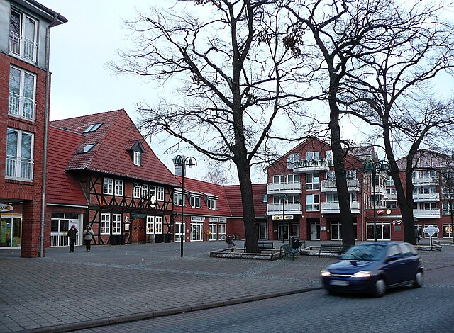
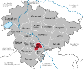
Hanover (Hannover)

- capital city of the German federated state of Lower Saxony
 Hiking in Hanover
Hanover, situated in lower Saxony, Germany, offers a variety of hiking opportunities that cater to different skill levels and preferences. Here are some highlights:
Scenic Trails
-
Landschaftsschutzgebiet Bockmer Holz: This protected area has well-marked trails that take you through diverse landscapes, including woodlands and meadows. It's a great spot to observe local wildlife.
-
Ihme and Leine River Trails: The riverbanks provide pleasant walking routes. The trails are mostly flat and suitable for families, offering beautiful views of the rivers and the surrounding nature.
-
Harz National Park: While a bit farther from Hanover, this national park is accessible for a day trip and offers stunning mountain scenery, with a variety of trails ranging from easy walks to challenging hikes.
Recommended Hikes
-
Deister Trails: Just southwest of Hanover, the Deister mountain range features numerous routes with varying difficulty levels. The trails offer fantastic views and are well-signposted. Popular routes include the Deister circular trail, which is about 18 kilometers long.
-
Kalihalde: The former mining site turned recreational area provides an easier hike with panoramic views of the surrounding landscape, including Hanover.
Tips for Hiking in Hanover
- Best Time to Go: Spring (April to June) and autumn (September to October) are the most pleasant times to hike due to mild temperatures and beautiful foliage.
- Weather Preparedness: Always check the weather forecast before heading out, as conditions can change quickly, especially in hilly areas.
- Equipment: Bring appropriate hiking gear, including sturdy shoes, water, and snacks. A map or a GPS device can also be helpful, especially on more remote trails.
Local Amenities
Hanover offers a range of amenities, including restaurants, cafes, and transportation options, making it easy to start and finish hiking excursions. Always remember to pack out what you pack in to maintain the natural beauty of the trails.
Overall, hiking in Hanover combines the charm of urban settings with access to beautiful natural landscapes, making it an enjoyable experience for all hiking enthusiasts.
- Country:

- Postal Code: 30159–30659
- Local Dialing Code: 0511
- Licence Plate Code: H
- Coordinates: 52° 22' 28" N, 9° 44' 19" E


- GPS tracks (wikiloc): [Link]
- AboveSeaLevel: 55 м m
- Area: 204.30 sq km
- Population: 532864
- Web site: https://www.hannover.de/
- Wikipedia en: wiki(en)
- Wikipedia: wiki(de)
- Wikidata storage: Wikidata: Q1715
- Wikipedia Commons Gallery: [Link]
- Wikipedia Commons Category: [Link]
- Wikipedia Commons Maps Category: [Link]
- Freebase ID: [/m/03pbf]
- GeoNames ID: Alt: [2910831]
- BnF ID: [11864270m]
- VIAF ID: Alt: [126622508]
- OSM relation ID: [59418]
- GND ID: Alt: [4023349-2]
- archINFORM location ID: [351]
- Library of Congress authority ID: Alt: [n79093323]
- MusicBrainz area ID: [eca79b55-a6c4-4078-a383-8353271ee81e]
- WOEID: [657169]
- Quora topic ID: [Hanover-Germany]
- TGN ID: [7013260]
- SUDOC authorities ID: [14872552X]
- Encyclopædia Britannica Online ID: [place/Hannover-Germany]
- Encyclopædia Universalis ID: [hanovre]
- EMLO location ID: [cb47da0b-f933-4fbb-9dfe-1c2c43730f59]
- Facebook Places ID: [110081962354501]
- Twitter username: Alt: [hannover]
- Great Russian Encyclopedia Online ID: [2344187]
- ISNI: Alt: [0000 0001 2331 5273]
- DMOZ ID: Alt: [Regional/Europe/Germany/States/Lower_Saxony/Localities/Hanover/]
- National Library of Israel ID: [000976491]
- NUTS code: [DE921]
- YSO ID: [125936]
- Nomisma ID: [hannover]
- Klexikon article ID: [Hannover]
- Brockhaus Enzyklopädie online ID: [hannover-40]
- Global Anabaptist Mennonite Encyclopedia Online ID: [Hannover (Niedersachsen, Germany)]
- FAST ID: [1206136]
- UK Parliament thesaurus ID: [35504]
- Catholic Encyclopedia ID: [07127c]
- Image Archive, Herder Institute: [Q1715]
- German municipality key: 03241001
- US National Archives Identifier: 10036554
Includes regions:
Döhren-Wülfel
- city district of Hanover
Hiking in Döhren-Wülfel
Döhren-Wülfel is a district in Hanover, Germany, known for its blend of urban and natural landscapes. While the area may not be as renowned for hiking as some national parks or wilderness areas, it does offer some pleasant walking paths and opportunities for outdoor activities. Here are some highlights for hiking enthusiasts in and around Döhren-Wülfel:...
- Country:
- Coordinates: 52° 19' 36" N, 9° 46' 34" E
- GPS tracks (wikiloc): [Link]
Ricklingen
- city district of Hanover
Hiking in Ricklingen
Ricklingen is a district in the city of Hanover, Germany, known for its suburban charm and accessibility to nature. While it may not be as renowned for hiking as some of the surrounding regions, there are still opportunities for walking and exploring the outdoors in and around Ricklingen....
- Country:
- Coordinates: 52° 20' 44" N, 9° 43' 7" E
- GPS tracks (wikiloc): [Link]
Kirchrode-Bemerode-Wülferode
- human settlement in Germany
Hiking in Kirchrode-Bemerode-Wülferode
Kirchrode-Bemerode-Wülferode is a scenic area located in the outskirts of Hanover, Germany. This area is known for its beautiful landscapes and accessibility for outdoor activities, making it an excellent spot for hiking enthusiasts. Here are some important details to consider if you're planning to hike in this region:...
- Country:
- Coordinates: 52° 20' 48" N, 9° 49' 59" E
- GPS tracks (wikiloc): [Link]
Linden-Limmer
- human settlement in Germany
Hiking in Linden-Limmer
Linden-Limmer is a district in Hanover, Germany, known for its residential areas and parks, but it may not be widely recognized for traditional hiking trails like those found in more mountainous or wilderness areas. However, you can still enjoy outdoor activities and light hiking within and around the area....
- Country:
- Coordinates: 52° 22' 8" N, 9° 42' 3" E
- GPS tracks (wikiloc): [Link]
Misburg-Anderten
- human settlement in Germany
Hiking in Misburg-Anderten
Misburg-Anderten is a district in the northeastern part of Hanover, Germany. While it may not be as renowned for hiking as some larger natural parks or mountain areas, there are still some beautiful trails and natural areas to explore....
- Country:
- Coordinates: 52° 22' 38" N, 9° 52' 3" E
- GPS tracks (wikiloc): [Link]

Hannover-Nordstadt
- human settlement in Germany
Hiking in Hannover-Nordstadt
Hannover-Nordstadt, located in the northern part of Hannover, Germany, offers a unique blend of urban hiking experiences and green spaces. While it may not be as famous for hiking as some other regions, there are several aspects to enjoy in this area:...
- Country:
- Coordinates: 52° 24' 38" N, 9° 43' 14" E
- GPS tracks (wikiloc): [Link]
Südstadt-Bult
- city district of Hanover, Germany
Hiking in Südstadt-Bult
Südstadt-Bult is a neighborhood located in Hanover, Germany. While it may not be a traditional hiking destination with vast trails found in national parks, it offers some pleasant walking opportunities, especially for those looking to explore urban nature and green spaces....
- Country:
- Coordinates: 52° 21' 15" N, 9° 46' 28" E
- GPS tracks (wikiloc): [Link]
Ahlem-Badenstedt-Davenstedt
- city district of Hanover
Hiking in Ahlem-Badenstedt-Davenstedt
Ahlem-Badenstedt-Davenstedt is a district in Hanover, Germany. While it may not be known for extensive hiking trails like some more rural regions, you can still find opportunities for pleasant walks and small hikes in and around the area. Here are some aspects to consider if you plan to explore hiking in this district:...
- Country:
- Coordinates: 52° 22' 0" N, 9° 40' 0" E
- GPS tracks (wikiloc): [Link]
Herrenhausen
- city district of Hanover
Hiking in Herrenhausen
Herrenhausen is primarily known for its beautiful gardens, specifically the Herrenhausen Gardens in Hanover, Germany. While it's not primarily a hiking destination, the area does offer opportunities for walking and enjoying nature, especially within the gardens themselves....
- Country:
- Coordinates: 52° 24' 14" N, 9° 41' 8" E
- GPS tracks (wikiloc): [Link]

Hanover-Mitte
- human settlement in Germany
Hiking in Hanover-Mitte
Hanover-Mitte, located in the heart of Hanover, Germany, is more urban than rural, but there are still opportunities for walking and hiking within its vicinity. Although you won't find extensive hiking trails directly in Hanover-Mitte, the area offers several parks and green spaces that provide great opportunities for short walks and enjoying nature, such as:...
- Country:
- Postal Code: 30175; 30169; 30167; 30161; 30159
- Coordinates: 52° 22' 11" N, 9° 43' 37" E
- GPS tracks (wikiloc): [Link]
Bothfeld-Vahrenheide (Hanover)
- city district of Hanover
Hiking in Bothfeld-Vahrenheide (Hanover)
Bothfeld-Vahrenheide is a district located in the city of Hannover, Germany. While it may not be known for extensive hiking trails like some national parks or nature reserves, there are opportunities for outdoor activities and walking in the area....
- Country:
- Coordinates: 52° 24' 56" N, 9° 46' 28" E
- GPS tracks (wikiloc): [Link]
Vahrenwald-List
- city district of Hanover
Hiking in Vahrenwald-List
Vahrenwald-List is a district in Hannover, Germany, known for its combination of urban parks and proximity to nature. While it may not be a primary destination for traditional hiking as one might find in national parks or mountainous areas, there are still several opportunities for outdoor activities and walks within and around the district....
- Country:
- Coordinates: 52° 23' 55" N, 9° 44' 57" E
- GPS tracks (wikiloc): [Link]
Buchholz-Kleefeld
- city district of Hanover
Hiking in Buchholz-Kleefeld
Buchholz-Kleefeld is a charming area in Germany, located near Hanover, known for its picturesque landscapes and lovely hiking trails. Here are some key points to consider if you’re thinking about hiking there:...
- Country:
- Coordinates: 52° 23' 8" N, 9° 48' 45" E
- GPS tracks (wikiloc): [Link]
Shares border with regions:


Laatzen
- town in the district of Hanover, in Lower Saxony, Germany
Hiking in Laatzen
Laatzen, located in Lower Saxony, Germany, offers access to several beautiful hiking opportunities, particularly within the surrounding areas, such as the nearby Hannover region and various trails in natural reserves. Here are some key points to consider if you're interested in hiking in or around Laatzen:...
- Country:
- Postal Code: 30880
- Local Dialing Code: 0511; 05102
- Licence Plate Code: H
- Coordinates: 52° 19' 0" N, 9° 48' 0" E
- GPS tracks (wikiloc): [Link]
- AboveSeaLevel: 46 м m
- Area: 34.05 sq km
- Population: 40939
- Web site: [Link]

Seelze
- town in the district of Hanover, in Lower Saxony, Germany
Hiking in Seelze
Seelze is a town located in Lower Saxony, Germany, situated just southwest of Hanover. While Seelze itself might not be primarily known as a hiking destination, there are several opportunities for outdoor enthusiasts in and around the area....
- Country:
- Postal Code: 30926
- Local Dialing Code: 05137; 0511; 05031
- Licence Plate Code: H
- Coordinates: 52° 23' 46" N, 9° 35' 53" E
- GPS tracks (wikiloc): [Link]
- AboveSeaLevel: 50 м m
- Area: 54.08 sq km
- Population: 34036
- Web site: [Link]


Garbsen
- town near Hanover, Lower Saxony, Germany
Hiking in Garbsen
Garbsen, located in Lower Saxony, Germany, is an area that offers a variety of outdoor activities, including hiking. While it may not be as widely known for hiking as some of the more mountainous areas in Germany, it does provide numerous opportunities to explore nature and enjoy the scenic landscape. Here are a few things to know about hiking in and around Garbsen:...
- Country:
- Postal Code: 30827; 30826; 30823
- Local Dialing Code: 05031; 05137; 05131
- Licence Plate Code: H
- Coordinates: 52° 25' 6" N, 9° 35' 53" E
- GPS tracks (wikiloc): [Link]
- AboveSeaLevel: 50 м m
- Area: 79.32 sq km
- Population: 60590
- Web site: [Link]


Langenhagen
- town in Lower Saxony, Germany
Hiking in Langenhagen
Langenhagen, located near Hanover in Germany, is not widely known as a hiking destination, but it does offer some pleasant walking and hiking opportunities in its surrounding areas. Here are some aspects to consider for hiking in and around Langenhagen:...
- Country:
- Postal Code: 30855; 30853; 30851; 30669
- Local Dialing Code: 0511
- Licence Plate Code: H
- Coordinates: 52° 26' 22" N, 9° 44' 24" E
- GPS tracks (wikiloc): [Link]
- AboveSeaLevel: 51 м m
- Area: 71.86 sq km
- Population: 53514
- Web site: [Link]


Isernhagen
- Municipality in Germany
Hiking in Isernhagen
Isernhagen, located in Lower Saxony, Germany, is primarily known for its quaint villages, scenic landscapes, and proximity to the city of Hannover. While it may not have the rugged mountain trails that larger national parks or mountainous regions offer, there are still plenty of opportunities for enjoyable hiking experiences in and around Isernhagen....
- Country:
- Postal Code: 30916
- Local Dialing Code: 05139; 05136; 0511
- Licence Plate Code: H
- Coordinates: 52° 26' 3" N, 9° 51' 26" E
- GPS tracks (wikiloc): [Link]
- AboveSeaLevel: 58 м m
- Area: 59.72 sq km
- Population: 24219
- Web site: [Link]

Hemmingen
- town in Lower Saxony, Germany
Hiking in Hemmingen
Hemming is a great area for hiking, offering various trails suited for different skill levels. Located near the region of Hanover in Germany, Hemmingen has access to both natural landscapes and historical sites....
- Country:
- Postal Code: 30953–30966
- Local Dialing Code: 0511; 05101
- Licence Plate Code: H
- Coordinates: 52° 19' 25" N, 9° 43' 32" E
- GPS tracks (wikiloc): [Link]
- AboveSeaLevel: 56 м m
- Area: 31.65 sq km
- Population: 18923
- Web site: [Link]


Gehrden
- district of Hanover, Germany
Hiking in Gehrden
Gehrden is a charming town located in Lower Saxony, Germany, and is surrounded by beautiful natural landscapes that are ideal for hiking enthusiasts. With its proximity to the foothills of the Harz Mountains and the scenic Burgwald and Deisterhill ranges, Gehrden offers a variety of hiking trails suitable for different skill levels....
- Country:
- Postal Code: 30989
- Local Dialing Code: 05137; 05109; 05108
- Licence Plate Code: H
- Coordinates: 52° 18' 42" N, 9° 36' 1" E
- GPS tracks (wikiloc): [Link]
- AboveSeaLevel: 78 м m
- Area: 42.97 sq km
- Population: 14903
- Web site: [Link]


Ronnenberg
- municipality of Germany
Hiking in Ronnenberg
Ronnenberg, located near the city of Hanover in Lower Saxony, Germany, offers a variety of hiking opportunities for outdoor enthusiasts. The region is characterized by scenic landscapes, lush forests, and rolling hills that provide a pleasant environment for hiking....
- Country:
- Postal Code: 30952
- Local Dialing Code: 0511; 05109; 05108
- Licence Plate Code: H
- Coordinates: 52° 19' 10" N, 9° 39' 20" E
- GPS tracks (wikiloc): [Link]
- AboveSeaLevel: 69 м m
- Area: 37.78 sq km
- Population: 24080
- Web site: [Link]


Sehnde
- municipality of Germany
Hiking in Sehnde
Sehnde is a quaint town located in Lower Saxony, Germany, not too far from Hanover. While it's not primarily known as a hiking destination, there are several beautiful trails and natural areas around Sehnde that outdoor enthusiasts can enjoy....
- Country:
- Postal Code: 31319
- Local Dialing Code: 05138; 05132
- Licence Plate Code: H
- Coordinates: 52° 18' 58" N, 9° 57' 51" E
- GPS tracks (wikiloc): [Link]
- AboveSeaLevel: 53 м m
- Area: 103.58 sq km
- Population: 23584
- Web site: [Link]


Lehrte
- town in the district of Hanover, in Lower Saxony, Germany
Hiking in Lehrte
Lehrte, located in Lower Saxony, Germany, offers a range of hiking opportunities for outdoor enthusiasts. While it is more of an urban area, there are still several options in and around Lehrte where you can enjoy nature and hiking....
- Country:
- Postal Code: 31275
- Local Dialing Code: 05175; 05136; 05132
- Licence Plate Code: H
- Coordinates: 52° 22' 21" N, 9° 58' 37" E
- GPS tracks (wikiloc): [Link]
- AboveSeaLevel: 62 м m
- Area: 127000000 sq km
- Population: 43720
- Web site: [Link]