
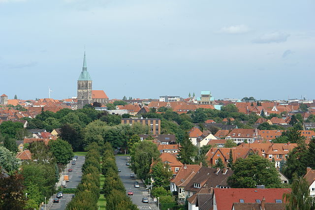
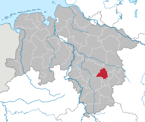
Hanover region (Region Hannover)

- district in Lower Saxony, Germany
 Hiking in Hanover region
The Hanover Region, located in Lower Saxony, Germany, offers a variety of hiking opportunities for both beginners and experienced hikers alike. With its mix of natural landscapes, historical sites, and well-maintained trails, the region is a great destination for outdoor enthusiasts.
Popular Hiking Areas
-
Deister Nature Park: Just south of Hanover, this park offers a range of trails at varying difficulty levels. The Deister Mountain range provides stunning views and diverse landscapes, including dense forests, rocky outcrops, and meadows.
-
Leine Valley: The Leine River runs through this picturesque valley, offering scenic hiking paths alongside the water. The routes here are relatively flat and perfect for a leisurely walk, making it family-friendly.
-
Ith Hills: Located a short drive from Hanover, the Ith Hills are known for their unique rock formations and dense woodlands. Hikers can enjoy trails that challenge their stamina while rewarding them with breathtaking panoramas.
-
Langenhagen: Close to Hanover, the surrounding areas of Langenhagen have lovely smaller trails that are accessible and ideal for short hikes or nature walks.
Trail Recommendations
-
Deister Höhenweg: A well-marked circular trail around the Deister region, offering views and a moderate hike through forests and past historical landmarks.
-
Leine-Radweg: While predominantly a cycling route, portions of this trail along the Leine River are great for hiking and allow you to explore the beautiful riverbanks.
-
Hiking in the Nature Reserves: The Hanover region has several nature reserves where you can hike and observe various flora and fauna. Make sure to check local guidelines to protect these natural areas.
Tips for Hiking in Hanover Region
-
Trail Maps and Signage: Most trails are well-marked, but it's wise to carry a map or have a hiking app downloaded. Tourist information centers can provide maps and additional trail information.
-
Weather: The weather can be variable, so check forecasts before heading out and dress in layers. Prepare for potential rain, as it’s common in the region.
-
Gear: Wear comfortable hiking shoes and take sufficient water, especially on longer hikes. Consider carrying snacks and packing a small first aid kit.
-
Respect Nature: Follow the Leave No Trace principles. Stay on marked paths, dispose of waste properly, and respect wildlife habitats.
Conclusion
Hiking in the Hanover Region can be a rewarding experience, offering opportunities to connect with nature, enjoy beautiful landscapes, and explore the local culture. Whether you're a seasoned hiker or just looking for a peaceful walk, there's something for everyone in this charming part of Germany. Enjoy your hiking adventures!
- Country:

- Capital: Hanover
- Licence Plate Code: H
- Coordinates: 52° 25' 12" N, 9° 43' 12" E


- GPS tracks (wikiloc): [Link]
- AboveSeaLevel: 55 м m
- Area: 2291 sq km
- Population: 1149594
- Web site: http://www.hannover.de
- Wikipedia en: wiki(en)
- Wikipedia: wiki(de)
- Wikidata storage: Wikidata: Q5963
- Wikipedia Commons Gallery: [Link]
- Wikipedia Commons Category: [Link]
- Wikipedia Commons Maps Category: [Link]
- Freebase ID: [/m/013_6w]
- GeoNames ID: Alt: [3221033]
- VIAF ID: Alt: [245858555]
- OSM relation ID: [62764]
- GND ID: Alt: [4790573-6]
- archINFORM location ID: [2443]
- Twitter username: Alt: [regionhannover_]
- NUTS code: [DE929]
- German district key: 03241
Includes regions:

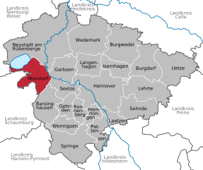
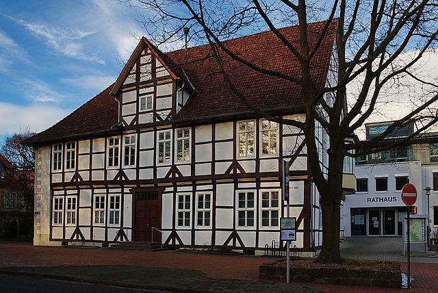
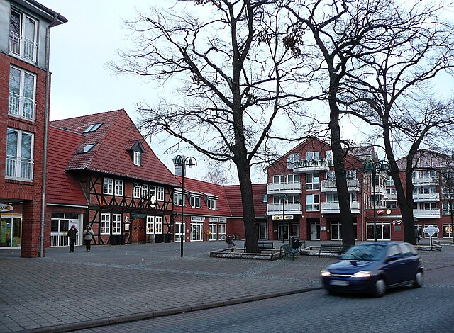
Wunstorf
- town in Lower Saxony, Germany
Hiking in Wunstorf
Wunstorf, located in Lower Saxony, Germany, is surrounded by beautiful natural landscapes that offer various hiking opportunities. While the area may not be as mountainous as some other regions in Germany, it still has plenty to offer for hiking enthusiasts....
- Country:
- Postal Code: 31515
- Local Dialing Code: 05723; 05033; 05031
- Licence Plate Code: H
- Coordinates: 52° 25' 26" N, 9° 26' 9" E
- GPS tracks (wikiloc): [Link]
- AboveSeaLevel: 43 м m
- Area: 126.60 sq km
- Population: 41532
- Web site: [Link]


Laatzen
- town in the district of Hanover, in Lower Saxony, Germany
Hiking in Laatzen
Laatzen, located in Lower Saxony, Germany, offers access to several beautiful hiking opportunities, particularly within the surrounding areas, such as the nearby Hannover region and various trails in natural reserves. Here are some key points to consider if you're interested in hiking in or around Laatzen:...
- Country:
- Postal Code: 30880
- Local Dialing Code: 0511; 05102
- Licence Plate Code: H
- Coordinates: 52° 19' 0" N, 9° 48' 0" E
- GPS tracks (wikiloc): [Link]
- AboveSeaLevel: 46 м m
- Area: 34.05 sq km
- Population: 40939
- Web site: [Link]

Barsinghausen
- town in Lower Saxony, Germany
Hiking in Barsinghausen
Barsinghausen is a town in Lower Saxony, Germany, that is surrounded by beautiful landscapes, making it an excellent location for hiking enthusiasts. Here are some highlights and details regarding hiking in and around Barsinghausen:...
- Country:
- Postal Code: 30890
- Local Dialing Code: 05108; 05035; 05105
- Licence Plate Code: H
- Coordinates: 52° 18' 0" N, 9° 28' 52" E
- GPS tracks (wikiloc): [Link]
- AboveSeaLevel: 142 м m
- Area: 102.65 sq km
- Population: 33922
- Web site: [Link]

Seelze
- town in the district of Hanover, in Lower Saxony, Germany
Hiking in Seelze
Seelze is a town located in Lower Saxony, Germany, situated just southwest of Hanover. While Seelze itself might not be primarily known as a hiking destination, there are several opportunities for outdoor enthusiasts in and around the area....
- Country:
- Postal Code: 30926
- Local Dialing Code: 05137; 0511; 05031
- Licence Plate Code: H
- Coordinates: 52° 23' 46" N, 9° 35' 53" E
- GPS tracks (wikiloc): [Link]
- AboveSeaLevel: 50 м m
- Area: 54.08 sq km
- Population: 34036
- Web site: [Link]


Hanover
- capital city of the German federated state of Lower Saxony
Hiking in Hanover
Hanover, situated in lower Saxony, Germany, offers a variety of hiking opportunities that cater to different skill levels and preferences. Here are some highlights:...
- Country:
- Postal Code: 30159–30659
- Local Dialing Code: 0511
- Licence Plate Code: H
- Coordinates: 52° 22' 28" N, 9° 44' 19" E
- GPS tracks (wikiloc): [Link]
- AboveSeaLevel: 55 м m
- Area: 204.30 sq km
- Population: 532864
- Web site: [Link]


Garbsen
- town near Hanover, Lower Saxony, Germany
Hiking in Garbsen
Garbsen, located in Lower Saxony, Germany, is an area that offers a variety of outdoor activities, including hiking. While it may not be as widely known for hiking as some of the more mountainous areas in Germany, it does provide numerous opportunities to explore nature and enjoy the scenic landscape. Here are a few things to know about hiking in and around Garbsen:...
- Country:
- Postal Code: 30827; 30826; 30823
- Local Dialing Code: 05031; 05137; 05131
- Licence Plate Code: H
- Coordinates: 52° 25' 6" N, 9° 35' 53" E
- GPS tracks (wikiloc): [Link]
- AboveSeaLevel: 50 м m
- Area: 79.32 sq km
- Population: 60590
- Web site: [Link]


Langenhagen
- town in Lower Saxony, Germany
Hiking in Langenhagen
Langenhagen, located near Hanover in Germany, is not widely known as a hiking destination, but it does offer some pleasant walking and hiking opportunities in its surrounding areas. Here are some aspects to consider for hiking in and around Langenhagen:...
- Country:
- Postal Code: 30855; 30853; 30851; 30669
- Local Dialing Code: 0511
- Licence Plate Code: H
- Coordinates: 52° 26' 22" N, 9° 44' 24" E
- GPS tracks (wikiloc): [Link]
- AboveSeaLevel: 51 м m
- Area: 71.86 sq km
- Population: 53514
- Web site: [Link]


Burgwedel
- municipality of Germany
Hiking in Burgwedel
Burgwedel, located in the Lower Saxony region of Germany, is not a mountainous area, but it offers some pleasant hiking opportunities, especially for those looking to explore picturesque landscapes and quaint rural settings. Here are some highlights for hiking in and around Burgwedel:...
- Country:
- Postal Code: 30938
- Local Dialing Code: 05139; 05135
- Licence Plate Code: H
- Coordinates: 52° 29' 36" N, 9° 51' 31" E
- GPS tracks (wikiloc): [Link]
- AboveSeaLevel: 53 м m
- Area: 151.96 sq km
- Population: 20594
- Web site: [Link]


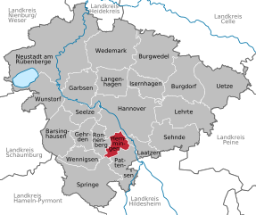
Pattensen
- town in the Region of Hannover, Lower Saxony, Germany
Hiking in Pattensen
Pattensen is a small town located near Hanover in Lower Saxony, Germany. While it may not be as popular as some larger hiking destinations, it offers access to beautiful trails and landscapes in the surrounding areas. Here are some highlights and tips for hiking in and around Pattensen:...
- Country:
- Postal Code: 30982
- Local Dialing Code: 05102; 05101; 05069; 05066
- Licence Plate Code: H
- Coordinates: 52° 15' 52" N, 9° 45' 52" E
- GPS tracks (wikiloc): [Link]
- AboveSeaLevel: 67 м m
- Area: 67 sq km
- Population: 14630
- Web site: [Link]


Wedemark
- municipality of Germany
Hiking in Wedemark
Wedemark is a beautiful region in Lower Saxony, Germany, known for its picturesque landscapes and diverse hiking opportunities. Located just to the north of Hanover, it offers a mix of forests, meadows, and small hills, making it an ideal spot for hikers of all levels. Here are some key points to consider when hiking in Wedemark:...
- Country:
- Postal Code: 30900
- Local Dialing Code: 05131; 05130; 05072
- Licence Plate Code: H
- Coordinates: 52° 32' 0" N, 9° 43' 0" E
- GPS tracks (wikiloc): [Link]
- AboveSeaLevel: 48 м m
- Area: 173 sq km
- Population: 29599
- Web site: [Link]


Isernhagen
- Municipality in Germany
Hiking in Isernhagen
Isernhagen, located in Lower Saxony, Germany, is primarily known for its quaint villages, scenic landscapes, and proximity to the city of Hannover. While it may not have the rugged mountain trails that larger national parks or mountainous regions offer, there are still plenty of opportunities for enjoyable hiking experiences in and around Isernhagen....
- Country:
- Postal Code: 30916
- Local Dialing Code: 05139; 05136; 0511
- Licence Plate Code: H
- Coordinates: 52° 26' 3" N, 9° 51' 26" E
- GPS tracks (wikiloc): [Link]
- AboveSeaLevel: 58 м m
- Area: 59.72 sq km
- Population: 24219
- Web site: [Link]

Hemmingen
- town in Lower Saxony, Germany
Hiking in Hemmingen
Hemming is a great area for hiking, offering various trails suited for different skill levels. Located near the region of Hanover in Germany, Hemmingen has access to both natural landscapes and historical sites....
- Country:
- Postal Code: 30953–30966
- Local Dialing Code: 0511; 05101
- Licence Plate Code: H
- Coordinates: 52° 19' 25" N, 9° 43' 32" E
- GPS tracks (wikiloc): [Link]
- AboveSeaLevel: 56 м m
- Area: 31.65 sq km
- Population: 18923
- Web site: [Link]


Gehrden
- district of Hanover, Germany
Hiking in Gehrden
Gehrden is a charming town located in Lower Saxony, Germany, and is surrounded by beautiful natural landscapes that are ideal for hiking enthusiasts. With its proximity to the foothills of the Harz Mountains and the scenic Burgwald and Deisterhill ranges, Gehrden offers a variety of hiking trails suitable for different skill levels....
- Country:
- Postal Code: 30989
- Local Dialing Code: 05137; 05109; 05108
- Licence Plate Code: H
- Coordinates: 52° 18' 42" N, 9° 36' 1" E
- GPS tracks (wikiloc): [Link]
- AboveSeaLevel: 78 м m
- Area: 42.97 sq km
- Population: 14903
- Web site: [Link]


Burgdorf
- municipality in Region Hannover, Germany
Hiking in Burgdorf
Burgdorf is a charming small town located just northeast of Hanover, Germany, and offers a variety of hiking opportunities for all levels of experience. Here are some aspects to consider when planning a hiking trip in the Burgdorf area:...
- Country:
- Postal Code: 31303
- Local Dialing Code: 05136; 05085
- Licence Plate Code: H
- Coordinates: 52° 27' 0" N, 10° 0' 30" E
- GPS tracks (wikiloc): [Link]
- AboveSeaLevel: 56 м m
- Area: 112.26 sq km
- Population: 30320
- Web site: [Link]


Ronnenberg
- municipality of Germany
Hiking in Ronnenberg
Ronnenberg, located near the city of Hanover in Lower Saxony, Germany, offers a variety of hiking opportunities for outdoor enthusiasts. The region is characterized by scenic landscapes, lush forests, and rolling hills that provide a pleasant environment for hiking....
- Country:
- Postal Code: 30952
- Local Dialing Code: 0511; 05109; 05108
- Licence Plate Code: H
- Coordinates: 52° 19' 10" N, 9° 39' 20" E
- GPS tracks (wikiloc): [Link]
- AboveSeaLevel: 69 м m
- Area: 37.78 sq km
- Population: 24080
- Web site: [Link]


Wennigsen
- municipality in Lower Saxony, Germany
Hiking in Wennigsen
Wennigsen, located in Lower Saxony, Germany, is surrounded by picturesque landscapes that provide opportunities for various hiking experiences. The region features rolling hills, lush forests, and scenic views, making it ideal for both casual walkers and more experienced hikers....
- Country:
- Postal Code: 30974
- Local Dialing Code: 05109; 05105; 05103
- Licence Plate Code: H
- Coordinates: 52° 16' 27" N, 9° 34' 15" E
- GPS tracks (wikiloc): [Link]
- AboveSeaLevel: 99 м m
- Area: 53.9 sq km
- Population: 14138
- Web site: [Link]


Springe
- municipality of Germany
Hiking in Springe
Springe is located in Lower Saxony, Germany, and is surrounded by beautiful natural landscapes, making it a fantastic destination for hiking enthusiasts. Here are some highlights and tips for hiking in Springe:...
- Country:
- Postal Code: 31832
- Local Dialing Code: 05045; 05044; 05041
- Licence Plate Code: H
- Coordinates: 52° 13' 0" N, 9° 33' 0" E
- GPS tracks (wikiloc): [Link]
- AboveSeaLevel: 107 м m
- Area: 159.78 sq km
- Population: 28918
- Web site: [Link]


Sehnde
- municipality of Germany
Hiking in Sehnde
Sehnde is a quaint town located in Lower Saxony, Germany, not too far from Hanover. While it's not primarily known as a hiking destination, there are several beautiful trails and natural areas around Sehnde that outdoor enthusiasts can enjoy....
- Country:
- Postal Code: 31319
- Local Dialing Code: 05138; 05132
- Licence Plate Code: H
- Coordinates: 52° 18' 58" N, 9° 57' 51" E
- GPS tracks (wikiloc): [Link]
- AboveSeaLevel: 53 м m
- Area: 103.58 sq km
- Population: 23584
- Web site: [Link]


Uetze
- municipality of Germany
Hiking in Uetze
Uetze, a small town located in Lower Saxony, Germany, offers a variety of scenic landscapes ideal for hiking enthusiasts. While it may not be as widely known for hiking as some other regions, it has its own charm with tranquil paths, lush forests, and quaint countryside views....
- Country:
- Postal Code: 31311
- Local Dialing Code: 05177; 05175; 05173; 05147
- Licence Plate Code: H
- Coordinates: 52° 27' 58" N, 10° 12' 14" E
- GPS tracks (wikiloc): [Link]
- AboveSeaLevel: 51 м m
- Area: 140.56 sq km
- Population: 20260
- Web site: [Link]


Neustadt am Rübenberge
- town in the district of Hanover, in Lower Saxony, Germany
Hiking in Neustadt am Rübenberge
Neustadt am Rübenberge, located in Lower Saxony, Germany, is surrounded by beautiful landscapes that offer various opportunities for hiking enthusiasts. Here are some key points about hiking in this region:...
- Country:
- Postal Code: 31535
- Local Dialing Code: 05074; 05073; 05072; 05036; 05034; 05032
- Licence Plate Code: H
- Coordinates: 52° 30' 0" N, 9° 28' 0" E
- GPS tracks (wikiloc): [Link]
- AboveSeaLevel: 37 м m
- Area: 357.52 sq km
- Population: 43931
- Web site: [Link]


Lehrte
- town in the district of Hanover, in Lower Saxony, Germany
Hiking in Lehrte
Lehrte, located in Lower Saxony, Germany, offers a range of hiking opportunities for outdoor enthusiasts. While it is more of an urban area, there are still several options in and around Lehrte where you can enjoy nature and hiking....
- Country:
- Postal Code: 31275
- Local Dialing Code: 05175; 05136; 05132
- Licence Plate Code: H
- Coordinates: 52° 22' 21" N, 9° 58' 37" E
- GPS tracks (wikiloc): [Link]
- AboveSeaLevel: 62 м m
- Area: 127000000 sq km
- Population: 43720
- Web site: [Link]
Shares border with regions:
Celle
- German district of Lower Saxony
Hiking in Celle
Celle district, located in Lower Saxony, Germany, offers a variety of hiking opportunities surrounded by beautiful landscapes, historic towns, and natural parks. Here are some highlights for hiking enthusiasts in the area:...
- Country:
- Licence Plate Code: CE
- Coordinates: 52° 34' 48" N, 10° 4' 48" E
- GPS tracks (wikiloc): [Link]
- AboveSeaLevel: 59 м m
- Area: 1554.00 sq km
- Population: 178370
- Web site: [Link]


Heidekreis
- district in Lower Saxony, Germany
Hiking in Heidekreis
Heidekreis, located in Lower Saxony, Germany, offers a variety of hiking opportunities amidst beautiful natural landscapes. The region is characterized by its mix of heathlands, forests, and moorlands, making it an attractive destination for outdoor enthusiasts....
- Country:
- Capital: Bad Fallingbostel
- Licence Plate Code: HK
- Coordinates: 52° 55' 12" N, 9° 45' 0" E
- GPS tracks (wikiloc): [Link]
- AboveSeaLevel: 64 м m
- Area: 1873.50 sq km
- Population: 139641
- Web site: [Link]


Nienburg/Weser
- district in Lower Saxony, Germany
Hiking in Nienburg/Weser
Nienburg (district) in Lower Saxony, Germany, offers a range of outdoor activities, including hiking, which can be enjoyed in its scenic landscapes. While the region isn't known for high mountains, it features beautiful rolling hills, tranquil rivers, and charming villages, making it an excellent area for hiking enthusiasts who appreciate more gentle terrains and lush nature....
- Country:
- Licence Plate Code: NI
- Coordinates: 52° 40' 12" N, 9° 10' 12" E
- GPS tracks (wikiloc): [Link]
- AboveSeaLevel: 21 м m
- Area: 1399.00 sq km
- Population: 121503
- Web site: [Link]
Schaumburg
- district in Lower Saxony, Germany
Hiking in Schaumburg
Schaumburg, located in northeastern Illinois, offers some enjoyable options for hiking, despite being a suburban area primarily known for its shopping and amenities. Here are a few notable spots you can explore:...
- Country:
- Licence Plate Code: SHG; RI
- Coordinates: 52° 15' 0" N, 9° 10' 12" E
- GPS tracks (wikiloc): [Link]
- AboveSeaLevel: 84 м m
- Area: 676.00 sq km
- Population: 157616
- Web site: [Link]


Hamelin-Pyrmont
- district in Lower Saxony, Germany
Hiking in Hamelin-Pyrmont
Hameln-Pyrmont, located in the Lower Saxony region of Germany, is a fantastic destination for hikers, offering a combination of beautiful landscapes, historical sites, and diverse trails. Here’s a detailed overview of what you can expect when hiking in this area:...
- Country:
- Capital: Hamelin
- Licence Plate Code: HM
- Coordinates: 52° 4' 48" N, 9° 19' 48" E
- GPS tracks (wikiloc): [Link]
- AboveSeaLevel: 91 м m
- Area: 796.00 sq km
- Population: 148265
- Web site: [Link]

Hildesheim
- district in Lower Saxony, Germany
Hiking in Hildesheim
Hildesheim is a beautiful district in Lower Saxony, Germany, known for its rich cultural heritage and scenic landscapes. While it may not be as famous for hiking as some other regions in Germany, there are still several great options for hikers of various skill levels....
- Country:
- Capital: Hildesheim
- Licence Plate Code: HI; ALF
- Coordinates: 52° 4' 48" N, 9° 55' 12" E
- GPS tracks (wikiloc): [Link]
- AboveSeaLevel: 80 м m
- Area: 1206.00 sq km
- Population: 277300
- Web site: [Link]

Peine
- district of Lower Saxony, Germany
Hiking in Peine
Peine is a district located in Lower Saxony, Germany, and it offers various outdoor activities, including hiking. The region is known for its beautiful landscapes, with a mix of forests, meadows, and picturesque villages. Here are some key points about hiking in the Peine district:...
- Country:
- Capital: Peine
- Licence Plate Code: PE
- Coordinates: 52° 19' 48" N, 10° 15' 0" E
- GPS tracks (wikiloc): [Link]
- AboveSeaLevel: 66 м m
- Area: 535.00 sq km
- Population: 132979
- Web site: [Link]


Gifhorn
- district of Lower Saxony, Germany
Hiking in Gifhorn
Gifhorn, located in Lower Saxony, Germany, is surrounded by beautiful landscapes that offer a variety of hiking opportunities. The district is characterized by its picturesque lakes, forests, and gentle hills, making it an attractive destination for hikers of all skill levels....
- Country:
- Capital: Gifhorn
- Licence Plate Code: GF
- Coordinates: 52° 29' 0" N, 10° 33' 0" E
- GPS tracks (wikiloc): [Link]
- AboveSeaLevel: 63 м m
- Area: 1563.00 sq km
- Population: 174749
- Web site: [Link]