Sillans (Sillans)
- commune in Isère, France
Sillans, nestled in the scenic Var department of Provence, France, is a beautiful destination for hiking enthusiasts. The area is known for its stunning natural landscapes, including lush forests, rolling hills, and picturesque waterfalls. Here are some highlights and information about hiking in Sillans:
Key Hiking Trails
-
Sillans-la-Cascade Trail: This is a popular trail leading to the breathtaking Sillans waterfall, where the crystal-clear waters cascade into a tranquil pool. The trail is relatively easy and suitable for families, making it a fantastic option for a leisurely hike and a great picnic spot.
-
GR4 Long-Distance Trail: This long-distance hiking path runs through the region and allows you to explore a broader area of Provence. Following the GR4 can lead you through various landscapes, connecting with other charming villages and sites of interest.
-
Surrounding Hills and Valleys: The hills surrounding Sillans offer numerous smaller trails that vary in difficulty. You can explore hidden gems, such as the local flora and fauna, and enjoy panoramic views of the countryside.
Things to Consider
-
Season: Spring (April to June) and fall (September to October) are ideal times for hiking in Sillans, as the weather is mild, and nature is in bloom or showcasing vibrant autumn colors.
-
Local Guidelines: Always check local regulations and trail markers before embarking on your hike. It’s also important to respect nature and wildlife by staying on marked trails and following Leave No Trace principles.
-
Gear: Wear sturdy hiking shoes, and depending on the time of year, dress in layers to accommodate changing weather conditions. Carry enough water, snacks, and a map or GPS device to navigate the trails.
-
Wildlife: Keep an eye out for local wildlife, and consider bringing binoculars for birdwatching.
Local Attractions
After a day of hiking, you may want to explore Sillans itself. The village is charming and offers opportunities to enjoy traditional Provençal cuisine, local markets, and perhaps a dip in the refreshing waters of the nearby waterfall.
Whether you're a casual walker or an experienced hiker, Sillans has something to offer everyone who loves the outdoors. Enjoy your hiking adventure!
- Country:

- Postal Code: 38590
- Coordinates: 45° 20' 27" N, 5° 23' 20" E


- GPS tracks (wikiloc): [Link]
- Area: 12.61 sq km
- Population: 1885
- Web site: http://www.mairie-sillans.com
- Wikipedia en: wiki(en)
- Wikipedia: wiki(fr)
- Wikidata storage: Wikidata: Q1067491
- Wikipedia Commons Category: [Link]
- Freebase ID: [/m/03nvktd]
- GeoNames ID: Alt: [6433421]
- SIREN number: [213804909]
- BnF ID: [15258294w]
- VIAF ID: Alt: [241194260]
- INSEE municipality code: 38490
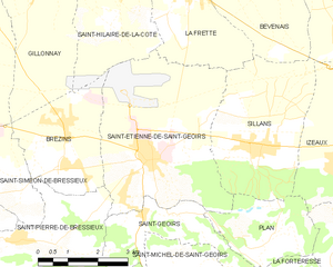
Shares border with regions:


Bévenais
- commune in Isère, France
Bévenais is a charming commune located in the Rhône department of France. It is situated near the foothills of the Massif Central, offering a picturesque landscape that is ideal for hiking enthusiasts. Here are some highlights about hiking in Bévenais:...
- Country:

- Postal Code: 38690
- Coordinates: 45° 23' 53" N, 5° 23' 22" E


- GPS tracks (wikiloc): [Link]
- Area: 14.08 sq km
- Population: 987
- Web site: [Link]


La Frette
- commune in Isère, France
La Frette, located in the Isère department of southeastern France, offers a variety of hiking opportunities that cater to different skill levels and preferences. Nestled in the picturesque landscape of the French Alps, La Frette is surrounded by stunning scenery, including mountains, forests, and rivers....
- Country:

- Postal Code: 38260
- Coordinates: 45° 23' 26" N, 5° 21' 38" E


- GPS tracks (wikiloc): [Link]
- Area: 11.8 sq km
- Population: 1108
- Web site: [Link]


Saint-Étienne-de-Saint-Geoirs
- commune in Isère, France
 Hiking in Saint-Étienne-de-Saint-Geoirs
Saint-Étienne-de-Saint-Geoirs, located in the Auvergne-Rhône-Alpes region of France, is surrounded by beautiful natural landscapes that are ideal for hiking enthusiasts. Here are some highlights and recommendations for hiking in this area:...
- Country:

- Postal Code: 38590
- Coordinates: 45° 20' 20" N, 5° 20' 43" E


- GPS tracks (wikiloc): [Link]
- Area: 18.62 sq km
- Population: 3259
- Web site: [Link]


Plan
- commune in Isère, France
Plan, located in the Isère department in the Auvergne-Rhône-Alpes region of France, is a fantastic area for hiking enthusiasts. The region is characterized by stunning natural beauty, including mountains, valleys, and rivers, making it an ideal destination for both casual walkers and experienced hikers. Here are some key aspects of hiking in and around Plan, Isère:...
- Country:

- Postal Code: 38590
- Coordinates: 45° 18' 46" N, 5° 23' 33" E


- GPS tracks (wikiloc): [Link]
- Area: 6.1 sq km
- Population: 256
- Web site: [Link]


Izeaux
- commune in Isère, France
Izeaux is a small commune located in the Isère department in the Auvergne-Rhône-Alpes region of southeastern France. Nestled in the foothills of the Alps, it offers a variety of hiking opportunities for both beginners and experienced hikers....
- Country:

- Postal Code: 38140
- Coordinates: 45° 20' 4" N, 5° 25' 27" E


- GPS tracks (wikiloc): [Link]
- Area: 15.54 sq km
- Population: 2154
- Web site: [Link]


Le Grand-Lemps
- commune in Isère, France
Le Grand-Lemps is a charming town located in the Isère department in southeastern France. It's an excellent base for hiking enthusiasts who want to explore the beautiful landscapes of the surrounding Vercors and Chartreuse mountain ranges. Here are some key points to consider when planning a hiking trip in Le Grand-Lemps:...
- Country:

- Postal Code: 38690
- Coordinates: 45° 23' 54" N, 5° 25' 11" E


- GPS tracks (wikiloc): [Link]
- Area: 12.9 sq km
- Population: 3082
- Web site: [Link]
