Sommerviller (Sommerviller)

- commune in Meurthe-et-Moselle, France
- Country:

- Postal Code: 54110
- Coordinates: 48° 37' 55" N, 6° 22' 35" E


- GPS tracks (wikiloc): [Link]
- Area: 3.81 sq km
- Population: 980
- Wikipedia en: wiki(en)
- Wikipedia: wiki(fr)
- Wikidata storage: Wikidata: Q1049472
- Wikipedia Commons Category: [Link]
- Freebase ID: [/m/03qdn6m]
- Freebase ID: [/m/03qdn6m]
- GeoNames ID: Alt: [6436866]
- GeoNames ID: Alt: [6436866]
- SIREN number: [215405093]
- SIREN number: [215405093]
- BnF ID: [152645761]
- BnF ID: [152645761]
- VIAF ID: Alt: [241876224]
- VIAF ID: Alt: [241876224]
- INSEE municipality code: 54509
- INSEE municipality code: 54509
Shares border with regions:
Flainval
- commune in Meurthe-et-Moselle, France
- Country:
- Postal Code: 54110
- Coordinates: 48° 37' 8" N, 6° 23' 56" E
- GPS tracks (wikiloc): [Link]
- Area: 3.61 sq km
- Population: 201

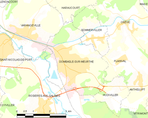
Dombasle-sur-Meurthe
- commune in Meurthe-et-Moselle, France
- Country:
- Postal Code: 54110
- Coordinates: 48° 37' 30" N, 6° 20' 59" E
- GPS tracks (wikiloc): [Link]
- Area: 11.21 sq km
- Population: 9828
- Web site: [Link]


Crévic
- commune in Meurthe-et-Moselle, France
- Country:
- Postal Code: 54110
- Coordinates: 48° 38' 20" N, 6° 24' 14" E
- GPS tracks (wikiloc): [Link]
- Area: 10.69 sq km
- Population: 889

Haraucourt
- commune in Meurthe-et-Moselle, France
- Country:
- Postal Code: 54110
- Coordinates: 48° 39' 41" N, 6° 21' 49" E
- GPS tracks (wikiloc): [Link]
- Area: 12.48 sq km
- Population: 719