Sonnay (Sonnay)

- commune in Isère, France
 Hiking in Sonnay
Sonnay is a charming village located in the Isère department of the Auvergne-Rhône-Alpes region in southeastern France. While Sonnay itself may not be as well-known as some other hiking destinations, it serves as a great starting point for exploring the surrounding natural beauty of the region.
Hiking Opportunities:
-
Surrounding Nature: The area around Sonnay features a variety of terrains, including rolling hills, forests, and rivers. You can find numerous trails that range from easy walks to more challenging hikes.
-
Regional Parks: Nearby natural reserves or parks, such as the Parc Naturel Régional de la Chartreuse or the Vercors, offer extensive trail systems. These parks boast stunning landscapes, wildlife, and panoramic views.
-
Local Trails: Be sure to explore local trails that may lead you through vineyards, charming countryside, or along the banks of the Rhône River. These paths often connect with other towns and villages, allowing you to enjoy a full day of hiking without the need for complex planning.
Tips for Hiking in Sonnay:
- Trail Maps: Always carry a map or a GPS device; while some trails may be well-marked, having a map ensures you stay on track.
- Weather Preparedness: Check the weather forecast before heading out, as conditions can change rapidly in mountainous areas.
- Hydration and Snacks: Bring enough water and some snacks to keep energy levels up during your hike.
- Footwear: Wear sturdy hiking shoes to navigate varying terrain comfortably and safely.
Local Amenities:
While Sonnay is a quaint village, it may have basic amenities such as small shops or cafes for rest and refreshments. If you're looking for more extensive facilities, nearby towns will typically have restaurants, gear shops, and accommodation options.
Conclusion:
Hiking in and around Sonnay offers a peaceful and scenic experience. Whether you're an experienced hiker or a beginner, the region’s beautiful landscapes and natural charm provide plenty of opportunities for exploration and adventure. Just make sure to plan ahead, and enjoy the stunning views that the Auvergne-Rhône-Alpes region has to offer!
- Country:

- Postal Code: 38150
- Coordinates: 45° 21' 17" N, 4° 54' 25" E


- GPS tracks (wikiloc): [Link]
- Area: 14.17 sq km
- Population: 1236
- Web site: http://www.sonnay.fr
- Wikipedia en: wiki(en)
- Wikipedia: wiki(fr)
- Wikidata storage: Wikidata: Q676142
- Wikipedia Commons Category: [Link]
- Freebase ID: [/m/03nvksc]
- GeoNames ID: Alt: [6433424]
- SIREN number: [213804966]
- BnF ID: [152582988]
- INSEE municipality code: 38496
Shares border with regions:


La Chapelle-de-Surieu
- commune in Isère, France
Hiking in La Chapelle-de-Surieu
La Chapelle-de-Surieu is a charming commune located in the Isère department in the Auvergne-Rhône-Alpes region of southeastern France. It offers a beautiful setting for hiking enthusiasts, with picturesque landscapes, rolling hills, and scenic views of the surrounding mountains....
- Country:
- Postal Code: 38150
- Coordinates: 45° 23' 28" N, 4° 54' 36" E
- GPS tracks (wikiloc): [Link]
- Area: 11.22 sq km
- Population: 752
- Web site: [Link]


Bougé-Chambalud
- commune in Isère, France
Hiking in Bougé-Chambalud
Bougé-Chambalud is a picturesque village located in the Auvergne-Rhône-Alpes region of France, specifically within the department of Drôme. Its setting offers several opportunities for hiking and enjoying the natural beauty of the area....
- Country:
- Postal Code: 38150
- Coordinates: 45° 19' 49" N, 4° 54' 5" E
- GPS tracks (wikiloc): [Link]
- Area: 15.85 sq km
- Population: 1395
- Web site: [Link]


Ville-sous-Anjou
- commune in Isère, France
Hiking in Ville-sous-Anjou
Ville-sous-Anjou, located in the Auvergne-Rhône-Alpes region of France, offers a variety of beautiful hiking trails that showcase the natural beauty of the surrounding landscape. While specific trails in Ville-sous-Anjou may not be widely documented, the region is known for its picturesque countryside, rolling hills, and proximity to national parks and natural reserves. Here are some key points to consider when hiking in this area:...
- Country:
- Postal Code: 38150
- Coordinates: 45° 21' 43" N, 4° 51' 49" E
- GPS tracks (wikiloc): [Link]
- Area: 18.25 sq km
- Population: 1203
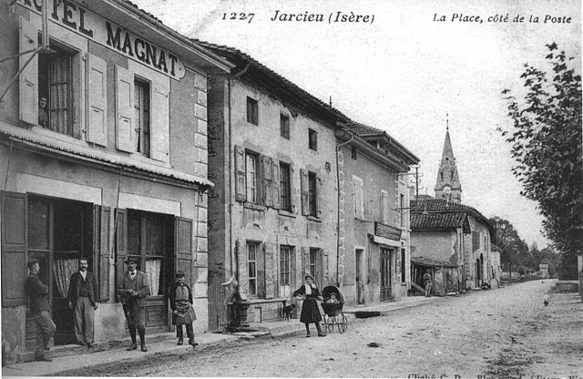
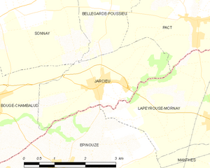
Jarcieu
- commune in Isère, France
Hiking in Jarcieu
Jarcieu is a charming village located in the Isère department in southeastern France. The area is surrounded by beautiful landscapes and offers a variety of opportunities for hiking enthusiasts, ranging from leisurely walks to more challenging trails. Here are some highlights and tips for hiking in Jarcieu:...
- Country:
- Postal Code: 38270
- Coordinates: 45° 20' 2" N, 4° 56' 47" E
- GPS tracks (wikiloc): [Link]
- Area: 6.31 sq km
- Population: 1028
- Web site: [Link]


Bellegarde-Poussieu
- commune in Isère, France
Hiking in Bellegarde-Poussieu
Bellegarde-Poussieu is a charming commune located in the Isère department in the Auvergne-Rhône-Alpes region of southeastern France. The area is known for its beautiful landscapes, rolling hills, and proximity to both the Rhône Valley and the foothills of the Alps, making it a great location for hiking enthusiasts....
- Country:
- Postal Code: 38270
- Coordinates: 45° 22' 30" N, 4° 57' 3" E
- GPS tracks (wikiloc): [Link]
- Area: 16.79 sq km
- Population: 982


Anjou
- commune in Isère, France
Hiking in Anjou
Anjou, located in the Isère department in the Auvergne-Rhône-Alpes region of southeastern France, offers a variety of beautiful landscapes and hiking opportunities. The area is known for its picturesque scenery, mixed forests, rolling hills, and views of the surrounding mountains, including the Alps....
- Country:
- Postal Code: 38150
- Coordinates: 45° 20' 49" N, 4° 52' 55" E
- GPS tracks (wikiloc): [Link]
- AboveSeaLevel: 182 м m
- Area: 5.03 sq km
- Population: 1012
- Web site: [Link]