Sours (Sours)

- commune in Eure-et-Loir, France
- Country:

- Postal Code: 28630
- Coordinates: 48° 24' 36" N, 1° 35' 50" E


- GPS tracks (wikiloc): [Link]
- Area: 33.15 sq km
- Population: 1927
- Wikipedia en: wiki(en)
- Wikipedia: wiki(fr)
- Wikidata storage: Wikidata: Q777769
- Wikipedia Commons Category: [Link]
- Freebase ID: [/m/03nm_by]
- GeoNames ID: Alt: [2973938]
- SIREN number: [212803803]
- BnF ID: [15254310b]
- INSEE municipality code: 28380
Shares border with regions:


Francourville
- commune in Eure-et-Loir, France
- Country:
- Postal Code: 28700
- Coordinates: 48° 24' 16" N, 1° 39' 40" E
- GPS tracks (wikiloc): [Link]
- Area: 18.46 sq km
- Population: 821


Berchères-les-Pierres
- commune in Eure-et-Loir, France
- Country:
- Postal Code: 28630
- Coordinates: 48° 23' 6" N, 1° 33' 13" E
- GPS tracks (wikiloc): [Link]
- Area: 19.83 sq km
- Population: 997
- Web site: [Link]


Nogent-le-Phaye
- commune in Eure-et-Loir, France
- Country:
- Postal Code: 28630
- Coordinates: 48° 26' 49" N, 1° 34' 35" E
- GPS tracks (wikiloc): [Link]
- Area: 15.01 sq km
- Population: 1378

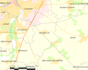
Gellainville
- commune in Eure-et-Loir, France
- Country:
- Postal Code: 28630
- Coordinates: 48° 24' 58" N, 1° 32' 0" E
- GPS tracks (wikiloc): [Link]
- Area: 12.01 sq km
- Population: 685
- Web site: [Link]


Houville-la-Branche
- commune in Eure-et-Loir, France
- Country:
- Postal Code: 28700
- Coordinates: 48° 26' 35" N, 1° 38' 30" E
- GPS tracks (wikiloc): [Link]
- Area: 13.88 sq km
- Population: 452


Prunay-le-Gillon
- commune in Eure-et-Loir, France
- Country:
- Postal Code: 28360
- Coordinates: 48° 21' 55" N, 1° 38' 7" E
- GPS tracks (wikiloc): [Link]
- Area: 25.36 sq km
- Population: 1069
- Web site: [Link]