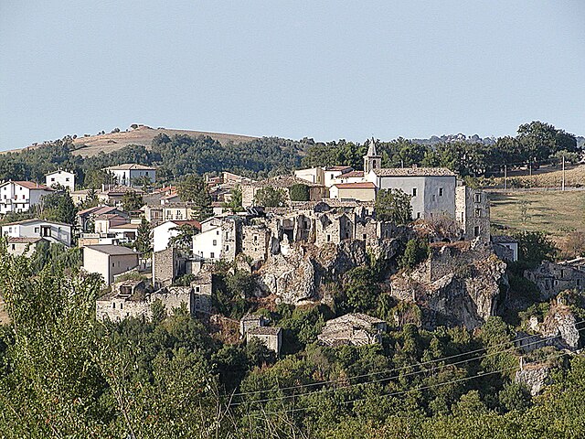
Torre de' Passeri (Torre de' Passeri)
.svg)
- Italian comune
 Hiking in Torre de' Passeri
Torre de' Passeri is a picturesque town located in the Abruzzo region of Italy, nestled within the beautiful Apennine Mountains. Hiking in and around Torre de' Passeri offers a mix of scenic landscapes, cultural experiences, and opportunities to explore the natural beauty of the region.
Hiking Options
-
Local Trails:
- There are several local trails that cater to various skill levels, ranging from leisurely walks to more challenging hikes.
- The trails often wind through forests, vineyards, and olive groves, providing stunning views of the surrounding countryside.
-
Nature Reserves:
- Nearby natural parks and reserves, like the Gran Sasso e Monti della Laga National Park, offer extensive hiking opportunities with well-marked paths and breathtaking scenery.
- You can explore diverse flora and fauna along these trails, making it ideal for nature enthusiasts.
-
Scenic Views:
- Many trails lead to viewpoints that overlook the valley and hills, making it perfect for photography and enjoying the serene beauty of the Italian landscape.
- During your hike, keep an eye out for local wildlife and the changing seasonal colors.
-
Historical Sites:
- Combine hiking with cultural exploration by visiting historical sites in the area, including medieval churches and ancient ruins along hiking routes.
Tips for Hiking in Torre de' Passeri
- Weather: Check local weather conditions before heading out, as mountain weather can change rapidly.
- Footwear: Wear sturdy, comfortable hiking boots for good support on varied terrain.
- Water and Snacks: Carry enough water and snacks, especially on longer hikes.
- Navigation: Use a map or GPS device, and consider downloading trail maps or guides online.
- Safety: Let someone know your hiking plans, especially if you’re venturing into less-trafficked areas.
Whether you're a seasoned hiker or a beginner, Torre de' Passeri's hiking opportunities offer a unique blend of natural beauty and cultural richness. Enjoy your outdoor adventure!
- Country:

- Postal Code: 65029
- Local Dialing Code: 085
- Licence Plate Code: PE
- Coordinates: 42° 14' 0" N, 13° 56' 0" E


- GPS tracks (wikiloc): [Link]
- AboveSeaLevel: 172 м m
- Area: 5.92 sq km
- Population: 3045
- Web site: http://www.comune.torredepasseri.pe.it/
- Wikipedia en: wiki(en)
- Wikipedia: wiki(it)
- Wikidata storage: Wikidata: Q51407
- Wikipedia Commons Category: [Link]
- Freebase ID: [/m/0fg8_k]
- GeoNames ID: Alt: [6541222]
- VIAF ID: Alt: [234712748]
- OSM relation ID: [41899]
- UN/LOCODE: [ITP9C]
- Digital Atlas of the Roman Empire ID: [23218]
- DMOZ ID: Alt: [Regional/Europe/Italy/Abruzzo/Localities/Torre_de'_Passeri/]
- ISTAT ID: 068043
- Italian cadastre code: L263
Shares border with regions:

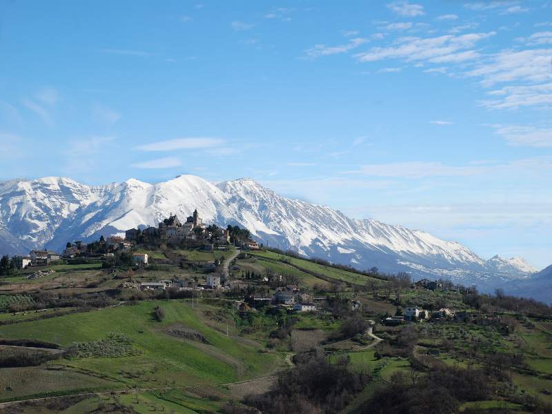
Bolognano
- Italian municipality
Hiking in Bolognano
Bolognano, a charming village in the Abruzzo region of Italy, is an excellent destination for hiking enthusiasts. Nestled in the foothills of the Apennines, it offers stunning landscapes, rich biodiversity, and a variety of trails suitable for different skill levels....
- Country:
- Postal Code: 65020
- Local Dialing Code: 085
- Licence Plate Code: PE
- Coordinates: 42° 13' 0" N, 13° 58' 0" E
- GPS tracks (wikiloc): [Link]
- AboveSeaLevel: 276 м m
- Area: 16.96 sq km
- Population: 1095
- Web site: [Link]


Alanno
- Italian comune
Hiking in Alanno
Alanno is a charming town located in the province of Pescara, in the Abruzzo region of Italy. It's surrounded by beautiful landscapes, making it a great destination for hiking enthusiasts. Here are some key points about hiking in and around Alanno:...
- Country:
- Postal Code: 65020
- Local Dialing Code: 085
- Licence Plate Code: PE
- Coordinates: 42° 18' 0" N, 13° 58' 0" E
- GPS tracks (wikiloc): [Link]
- AboveSeaLevel: 307 м m
- Area: 32.53 sq km
- Population: 3466
- Web site: [Link]


Castiglione a Casauria
- Italian comune
Hiking in Castiglione a Casauria
Castiglione a Casauria is a picturesque village located in the Abruzzo region of Italy, nestled in the foothills of the Apennines. The area is known for its stunning natural landscapes, historical sites, and outdoor activities, making it a great destination for hiking enthusiasts....
- Country:
- Postal Code: 65020
- Local Dialing Code: 085
- Licence Plate Code: PE
- Coordinates: 42° 14' 13" N, 13° 53' 54" E
- GPS tracks (wikiloc): [Link]
- AboveSeaLevel: 350 м m
- Area: 16.57 sq km
- Population: 802
- Web site: [Link]

Pietranico
- Italian comune
Hiking in Pietranico
Pietranico is a small village located in the Abruzzo region of Italy, surrounded by stunning natural landscapes that are perfect for hiking enthusiasts. Nestled in the foothills of the Gran Sasso mountain range, Pietranico offers a variety of trails suitable for different skill levels, from leisurely walks to more challenging hikes....
- Country:
- Postal Code: 65020
- Local Dialing Code: 085
- Licence Plate Code: PE
- Coordinates: 42° 17' 0" N, 13° 55' 0" E
- GPS tracks (wikiloc): [Link]
- AboveSeaLevel: 590 м m
- Area: 14.77 sq km
- Population: 477
- Web site: [Link]
Scafa
- Italian comune
Hiking in Scafa
Scafa, located in the Abruzzo region of Italy, is a charming destination for hiking enthusiasts. Nestled near the foothills of the Apennine Mountains, it offers access to a variety of natural landscapes, from rolling hills to more rugged terrain....
- Country:
- Postal Code: 65027
- Local Dialing Code: 085
- Licence Plate Code: PE
- Coordinates: 42° 15' 57" N, 13° 59' 48" E
- GPS tracks (wikiloc): [Link]
- AboveSeaLevel: 108 м m
- Area: 10.34 sq km
- Population: 3656
- Web site: [Link]