Tulette (Tulette)
- commune in Drôme, France
Tulette is a charming commune located in the Vaucluse department of the Provence-Alpes-Côte d'Azur region in southeastern France. While it's not a major hiking destination like some of the larger national parks or mountain ranges in France, it offers a lovely setting for those looking to enjoy a more relaxed hiking experience in the French countryside.
Hiking Opportunities:
-
Local Trails: Around Tulette, you can find various walking paths that traverse vineyards and olive groves. The rolling hills and picturesque landscapes provide a beautiful backdrop for leisurely hikes.
-
Vaucluse Countryside: The surrounding area includes several rural roads and trails. Hiking here allows you to experience the peaceful rural lifestyle and enjoy the seasonal changes of the lush countryside.
-
Nearby Destinations: If you're willing to venture a bit further, you can explore the larger natural areas in the Vaucluse region, such as the Mont Ventoux, a popular hiking spot known for its stunning views and challenging trails.
-
Guided Hikes: Depending on the season, there may be organized hikes or guided tours in the area, where you can learn more about the local flora and fauna.
Things to Consider:
- Difficulty Level: Most trails around Tulette are relatively easy to moderate, making them suitable for families and casual hikers.
- Preparation: Always take the usual precautions: wear appropriate footwear, carry water, and check the weather before heading out.
- Local Attractions: Consider combining your hike with visits to local markets or vineyards to taste the exquisite wines of the region.
Whether it’s a short stroll through the vineyards or an adventurous trek in nearby hills, hiking in and around Tulette can be a delightful way to experience the natural beauty and charm of the Provence region.
- Country:

- Postal Code: 26790
- Coordinates: 44° 17' 11" N, 4° 55' 51" E


- GPS tracks (wikiloc): [Link]
- Area: 23.53 sq km
- Population: 1963
- Wikipedia en: wiki(en)
- Wikipedia: wiki(fr)
- Wikidata storage: Wikidata: Q266054
- Wikipedia Commons Category: [Link]
- Freebase ID: [/m/0cf7v8]
- Freebase ID: [/m/0cf7v8]
- GeoNames ID: Alt: [2971483]
- GeoNames ID: Alt: [2971483]
- SIREN number: [212603575]
- SIREN number: [212603575]
- BnF ID: [152532177]
- BnF ID: [152532177]
- WOEID: [629520]
- WOEID: [629520]
- INSEE municipality code: 26357
- INSEE municipality code: 26357
Shares border with regions:


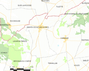
Sainte-Cécile-les-Vignes
- commune in Vaucluse, France
- Country:

- Postal Code: 84290
- Coordinates: 44° 14' 43" N, 4° 53' 10" E


- GPS tracks (wikiloc): [Link]
- Area: 19.82 sq km
- Population: 2445


Visan
- commune in Vaucluse, France
Visan, a charming commune located in the Vaucluse department in the Provence-Alpes-Côte d'Azur region of France, offers a delightful setting for hiking enthusiasts. The region is known for its picturesque landscapes, historic villages, and diverse flora and fauna....
- Country:

- Postal Code: 84820
- Coordinates: 44° 18' 53" N, 4° 57' 2" E


- GPS tracks (wikiloc): [Link]
- Area: 41.07 sq km
- Population: 1961
- Web site: [Link]


Saint-Roman-de-Malegarde
- commune in Vaucluse, France
 Hiking in Saint-Roman-de-Malegarde
Saint-Roman-de-Malegarde is a charming commune located in the Provence-Alpes-Côte d'Azur region of France, nestled at the foothills of the Dentelles de Montmirail mountains. This area provides a fantastic opportunity for hiking enthusiasts. Here are some key points to consider when exploring the hiking options in and around Saint-Roman-de-Malegarde:...
- Country:

- Postal Code: 84290
- Coordinates: 44° 16' 12" N, 4° 57' 48" E


- GPS tracks (wikiloc): [Link]
- Area: 8.21 sq km
- Population: 331


Suze-la-Rousse
- commune in Drôme, France
- Country:

- Postal Code: 26790
- Coordinates: 44° 17' 17" N, 4° 50' 32" E


- GPS tracks (wikiloc): [Link]
- Area: 30.6 sq km
- Population: 2066


Saint-Maurice-sur-Eygues
- commune in Drôme, France
 Hiking in Saint-Maurice-sur-Eygues
Saint-Maurice-sur-Eygues is a charming village located in the Drôme department of the Auvergne-Rhône-Alpes region in southeastern France. The region offers beautiful landscapes, diverse flora and fauna, and a variety of hiking opportunities that cater to different skill levels....
- Country:

- Postal Code: 26110
- Coordinates: 44° 17' 54" N, 5° 0' 39" E


- GPS tracks (wikiloc): [Link]
- Area: 8.82 sq km
- Population: 760
- Web site: [Link]


Buisson
- commune in Vaucluse, France
Buisson, located in the Vaucluse department of the Provence-Alpes-Côte d'Azur region in southeastern France, is known for its beautiful landscapes and scenic hiking opportunities. The area offers a mix of natural beauty, historical sites, and charming villages, making it an attractive destination for hikers of all levels....
- Country:

- Postal Code: 84110
- Coordinates: 44° 16' 49" N, 4° 59' 52" E


- GPS tracks (wikiloc): [Link]
- Area: 9.49 sq km
- Population: 294


Bouchet
- commune in Drôme, France
Bouchet is a charming village located in the Drôme department of the Auvergne-Rhône-Alpes region in southeastern France. It is surrounded by stunning landscapes, making it an excellent destination for hiking enthusiasts. Here are some key points to consider when hiking in and around Bouchet:...
- Country:

- Postal Code: 26790
- Coordinates: 44° 17' 57" N, 4° 52' 23" E


- GPS tracks (wikiloc): [Link]
- Area: 11.89 sq km
- Population: 1454
