Vaulnaveys-le-Haut (Vaulnaveys-le-Haut)

- commune in Isère, France
 Hiking in Vaulnaveys-le-Haut
Vaulnaveys-le-Haut is a charming village located in the French Alps, nestled just south of Grenoble. This picturesque area offers a variety of hiking opportunities for outdoor enthusiasts of all skill levels. The beautiful landscapes, stunning mountain views, and rich natural surroundings make it an ideal destination for hiking.
Key Features of Hiking in Vaulnaveys-le-Haut:
-
Scenic Trails: The trails around Vaulnaveys-le-Haut often provide breathtaking views of the surrounding peaks, forests, and valleys. You can explore a range of paths, from easy walks suitable for families to more challenging hikes for experienced trekkers.
-
Diverse Flora and Fauna: The region is home to a rich diversity of plant and animal life. Hikers may spot various species of trees, wildflowers, and sometimes even wildlife like deer or chamois in their natural habitat.
-
Accessibility: Vaulnaveys-le-Haut is relatively easy to access from Grenoble, making it a great destination for a day trip or a weekend getaway for those looking to escape the hustle of the city for nature.
-
Cultural Heritage: Some trails may lead you past historical landmarks or local cultural sites, allowing hikers to appreciate the heritage of the area in addition to its natural beauty.
-
Seasonal Hiking: The best time for hiking in Vaulnaveys-le-Haut is typically from spring to autumn when the weather is more favorable, and the trails are clear of snow. However, winter hiking and snowshoeing can also be enjoyed in this region for those looking for a different experience.
Popular Hiking Routes:
- Barrage de Pierre-Châtel: This trail leads you around a beautiful lake created by the dam, providing stunning views and a relatively easy hike.
- Col de l'Arc: A more challenging route that offers breathtaking vistas of the surrounding mountains and is popular among experienced hikers.
- Les Sentiers de Découverte: Various nature trails designed to educate hikers about the local ecosystem while enjoying the scenery.
Tips for Hiking in Vaulnaveys-le-Haut:
- Stay Hydrated: Always carry enough water, especially during warmer months.
- Proper Footwear: Wear sturdy hiking boots to tackle various terrains safely.
- Trail Maps and Signage: Make use of local maps and follow marked trails to avoid getting lost.
- Weather Awareness: Check the weather forecast before heading out, as conditions in the mountains can change rapidly.
Conclusion
Vaulnaveys-le-Haut is an excellent location for hikers looking for beautiful scenery, diverse trails, and a chance to experience the natural beauty of the French Alps. Whether you’re a beginner or an experienced hiker, there's something for everyone in this stunning mountain region.
- Country:

- Postal Code: 38410
- Coordinates: 45° 7' 6" N, 5° 48' 37" E


- GPS tracks (wikiloc): [Link]
- Area: 19.86 sq km
- Population: 3707
- Web site: http://www.mairie-vaulnaveys-le-haut.fr
- Wikipedia en: wiki(en)
- Wikipedia: wiki(fr)
- Wikidata storage: Wikidata: Q1066557
- Wikipedia Commons Category: [Link]
- Freebase ID: [/m/03nvgk7]
- GeoNames ID: Alt: [6433444]
- SIREN number: [213805294]
- BnF ID: [15258329q]
- VIAF ID: Alt: [147699861]
- SUDOC authorities ID: [034414754]
- INSEE municipality code: 38529
Shares border with regions:

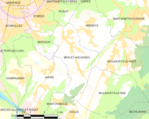
Brié-et-Angonnes
- commune in Isère, France
Hiking in Brié-et-Angonnes
Brié-et-Angonnes is a charming commune located in the Auvergne-Rhône-Alpes region of France, situated near the city of Grenoble. The area offers a variety of hiking opportunities that cater to different skill levels, making it a great destination for both beginners and experienced hikers....
- Country:
- Postal Code: 38320
- Coordinates: 45° 6' 41" N, 5° 47' 12" E
- GPS tracks (wikiloc): [Link]
- Area: 9.7 sq km
- Population: 2531
- Web site: [Link]


Herbeys
- commune in Isère, France
Hiking in Herbeys
Herbeys is a charming village located near the French Alps, offering a range of hiking opportunities for outdoor enthusiasts. Here are some highlights and tips for hiking in Herbeys:...
- Country:
- Postal Code: 38320
- Coordinates: 45° 8' 20" N, 5° 47' 36" E
- GPS tracks (wikiloc): [Link]
- Area: 7.73 sq km
- Population: 1364
- Web site: [Link]


Saint-Martin-d'Uriage
- commune in Isère, France
Hiking in Saint-Martin-d'Uriage
Saint-Martin-d'Uriage is a charming commune located in the Isère department of southeastern France. Nestled at the foothills of the Belledonne mountain range, it offers a variety of hiking opportunities that cater to different skill levels and preferences....
- Country:
- Postal Code: 38410
- Coordinates: 45° 9' 8" N, 5° 50' 21" E
- GPS tracks (wikiloc): [Link]
- Area: 29.69 sq km
- Population: 5408
- Web site: [Link]


Séchilienne
- commune in Isère, France
Hiking in Séchilienne
Séchilienne is a charming village located in the Isère department of the Auvergne-Rhône-Alpes region in southeastern France. Nestled in the mountains, it offers beautiful hiking opportunities with stunning views of the surrounding landscapes....
- Country:
- Postal Code: 38220
- Coordinates: 45° 3' 17" N, 5° 50' 6" E
- GPS tracks (wikiloc): [Link]
- Area: 21.47 sq km
- Population: 1021

Vaulnaveys-le-Bas
- commune in Isère, France
Hiking in Vaulnaveys-le-Bas
Vaulnaveys-le-Bas is a charming village located in the Isère department of the Auvergne-Rhône-Alpes region in southeastern France. The area is surrounded by beautiful natural landscapes, making it an excellent destination for hiking enthusiasts. Here are some insights and tips for hiking in and around Vaulnaveys-le-Bas:...
- Country:
- Postal Code: 38410
- Coordinates: 45° 6' 22" N, 5° 48' 20" E
- GPS tracks (wikiloc): [Link]
- Area: 11.9 sq km
- Population: 1247
- Web site: [Link]
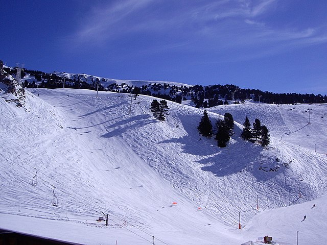

Chamrousse
- commune in Isère, France
Hiking in Chamrousse
Chamrousse, located in the French Alps, is a fantastic destination for hiking enthusiasts, offering stunning landscapes, a variety of trails, and the opportunity to experience the natural beauty of the region. Here are some key points to consider when planning a hiking trip in Chamrousse:...
- Country:
- Postal Code: 38410
- Coordinates: 45° 6' 42" N, 5° 52' 30" E
- GPS tracks (wikiloc): [Link]
- AboveSeaLevel: 1660 м m
- Area: 13.29 sq km
- Population: 462
- Web site: [Link]