Séchilienne (Séchilienne)
- commune in Isère, France
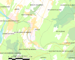
Séchilienne is a charming village located in the Isère department of the Auvergne-Rhône-Alpes region in southeastern France. Nestled in the mountains, it offers beautiful hiking opportunities with stunning views of the surrounding landscapes.
Hiking Opportunities
-
Scenic Trails: The area is well-known for its diverse hiking trails, which range from easy walks suitable for families to more challenging hikes for experienced trekkers. Many of these trails provide panoramic views of the Vercors and Chartreuse mountains.
-
Les Sentiers de Séchilienne: This local network of trails allows hikers to explore the natural beauty and diversity of the region. They offer a variety of terrains, including woodlands, meadows, and rocky outcrops.
-
Belvedere de la Dent de Crolles: One of the popular hikes in the area leads to the Dent de Crolles, providing breathtaking views of the entire region. The hike is moderately strenuous but rewards adventurers with fantastic photo opportunities.
-
Wildlife and Flora: As you hike, be sure to pay attention to the local wildlife, including various bird species and possibly deer or chamois. The area is also rich in flora, with many unique alpine plants.
-
Nearby Hikes: Séchilienne serves as a gateway to larger hiking areas like the Vercors Regional Natural Park, where hikers can find more extensive trail systems and additional high-altitude hiking options.
Tips for Hiking in Séchilienne
- Prepare Accordingly: Always check the weather before heading out, as mountain weather can change rapidly.
- Wear Proper Footwear: Sturdy hiking boots with good ankle support are recommended, especially on rocky or uneven terrain.
- Stay Hydrated: Bring plenty of water, especially during warmer months, as some trails may not have water sources.
- Local Maps: Carry a detailed hiking map of the area or use a reliable GPS app on your phone for navigation.
Conclusion
Séchilienne is a lovely destination for hiking enthusiasts looking to experience the natural beauty of the French Alps. Whether you are a casual walker or an experienced hiker, the area offers something for everyone. Enjoy your adventure!
- Country:

- Postal Code: 38220
- Coordinates: 45° 3' 17" N, 5° 50' 6" E


- GPS tracks (wikiloc): [Link]
- Area: 21.47 sq km
- Population: 1021
- Wikipedia en: wiki(en)
- Wikipedia: wiki(fr)
- Wikidata storage: Wikidata: Q378689
- Wikipedia Commons Category: [Link]
- Freebase ID: [/m/03nvjb9]
- GeoNames ID: Alt: [2975364]
- SIREN number: [213804784]
- BnF ID: [152582837]
- MusicBrainz area ID: [4a9315c5-c2b5-41fb-9f1e-4def557d16bc]
- WOEID: [621553]
- INSEE municipality code: 38478
Shares border with regions:


Vaulnaveys-le-Haut
- commune in Isère, France
Vaulnaveys-le-Haut is a charming village located in the French Alps, nestled just south of Grenoble. This picturesque area offers a variety of hiking opportunities for outdoor enthusiasts of all skill levels. The beautiful landscapes, stunning mountain views, and rich natural surroundings make it an ideal destination for hiking....
- Country:

- Postal Code: 38410
- Coordinates: 45° 7' 6" N, 5° 48' 37" E


- GPS tracks (wikiloc): [Link]
- Area: 19.86 sq km
- Population: 3707
- Web site: [Link]


Saint-Barthélemy-de-Séchilienne
- commune in Isère, France
 Hiking in Saint-Barthélemy-de-Séchilienne
Saint-Barthélemy-de-Séchilienne is a charming commune situated in the Isère department of the Auvergne-Rhône-Alpes region in southeastern France. Nestled in the foothills of the French Alps, this area offers beautiful scenery and a range of hiking opportunities for outdoor enthusiasts. Here's what you can expect when hiking in this region:...
- Country:

- Postal Code: 38220
- Coordinates: 45° 2' 39" N, 5° 49' 34" E


- GPS tracks (wikiloc): [Link]
- AboveSeaLevel: 450 м m
- Area: 12.1 sq km
- Population: 454


Vaulnaveys-le-Bas
- commune in Isère, France
Vaulnaveys-le-Bas is a charming village located in the Isère department of the Auvergne-Rhône-Alpes region in southeastern France. The area is surrounded by beautiful natural landscapes, making it an excellent destination for hiking enthusiasts. Here are some insights and tips for hiking in and around Vaulnaveys-le-Bas:...
- Country:

- Postal Code: 38410
- Coordinates: 45° 6' 22" N, 5° 48' 20" E


- GPS tracks (wikiloc): [Link]
- Area: 11.9 sq km
- Population: 1247
- Web site: [Link]


Vizille
- commune in Isère, France
Vizille, located in the Isère department of southeastern France, is a lovely area known for its picturesque landscapes, rich history, and access to the stunning scenery of the French Alps. Hiking in and around Vizille offers various trails that cater to different skill levels, from leisurely walks to more challenging hikes....
- Country:

- Postal Code: 38220
- Coordinates: 45° 4' 42" N, 5° 46' 19" E


- GPS tracks (wikiloc): [Link]
- Area: 10.51 sq km
- Population: 7468
- Web site: [Link]


Chamrousse
- commune in Isère, France
Chamrousse, located in the French Alps, is a fantastic destination for hiking enthusiasts, offering stunning landscapes, a variety of trails, and the opportunity to experience the natural beauty of the region. Here are some key points to consider when planning a hiking trip in Chamrousse:...
- Country:

- Postal Code: 38410
- Coordinates: 45° 6' 42" N, 5° 52' 30" E


- GPS tracks (wikiloc): [Link]
- AboveSeaLevel: 1660 м m
- Area: 13.29 sq km
- Population: 462
- Web site: [Link]


Livet-et-Gavet
- commune in Isère, France
Livet-et-Gavet, located in the Auvergne-Rhône-Alpes region of France, is a picturesque destination for hiking enthusiasts. This area is characterized by its stunning natural landscapes, including lush forests, rivers, and mountainous terrain. Here are some highlights and tips for hiking in Livet-et-Gavet:...
- Country:

- Postal Code: 38220
- Coordinates: 45° 5' 28" N, 5° 54' 9" E


- GPS tracks (wikiloc): [Link]
- Area: 46.54 sq km
- Population: 1296
- Web site: [Link]
