Vereaux (Vereaux)

- commune in Cher, France
- Country:

- Postal Code: 18600
- Coordinates: 46° 52' 47" N, 2° 52' 45" E


- GPS tracks (wikiloc): [Link]
- Area: 22.96 sq km
- Population: 143
- Wikipedia en: wiki(en)
- Wikipedia: wiki(fr)
- Wikidata storage: Wikidata: Q1422912
- Wikipedia Commons Category: [Link]
- Freebase ID: [/m/03mffj7]
- GeoNames ID: Alt: [6428327]
- SIREN number: [211802756]
- BnF ID: [15249621t]
- INSEE municipality code: 18275
Shares border with regions:


Ourouer-les-Bourdelins
- commune in Cher, France
- Country:
- Postal Code: 18350
- Coordinates: 46° 55' 50" N, 2° 47' 3" E
- GPS tracks (wikiloc): [Link]
- Area: 24.64 sq km
- Population: 626

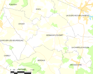
Germigny-l'Exempt
- commune in Cher, France
- Country:
- Postal Code: 18150
- Coordinates: 46° 55' 5" N, 2° 53' 54" E
- GPS tracks (wikiloc): [Link]
- Area: 28.26 sq km
- Population: 311

Grossouvre
- commune in Cher, France
- Country:
- Postal Code: 18600
- Coordinates: 46° 52' 43" N, 2° 56' 14" E
- GPS tracks (wikiloc): [Link]
- Area: 15.75 sq km
- Population: 283
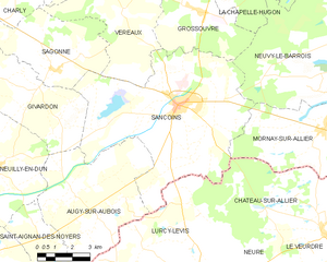
Sancoins
- commune in Cher, France
- Country:
- Postal Code: 18600
- Coordinates: 46° 49' 55" N, 2° 55' 8" E
- GPS tracks (wikiloc): [Link]
- Area: 53.52 sq km
- Population: 3107
- Web site: [Link]


Sagonne
- commune in Cher, France
- Country:
- Postal Code: 18600
- Coordinates: 46° 51' 1" N, 2° 49' 30" E
- GPS tracks (wikiloc): [Link]
- Area: 18.85 sq km
- Population: 182

Charly
- commune in Cher, France
- Country:
- Postal Code: 18350
- Coordinates: 46° 53' 57" N, 2° 44' 56" E
- GPS tracks (wikiloc): [Link]
- Area: 25.66 sq km
- Population: 253