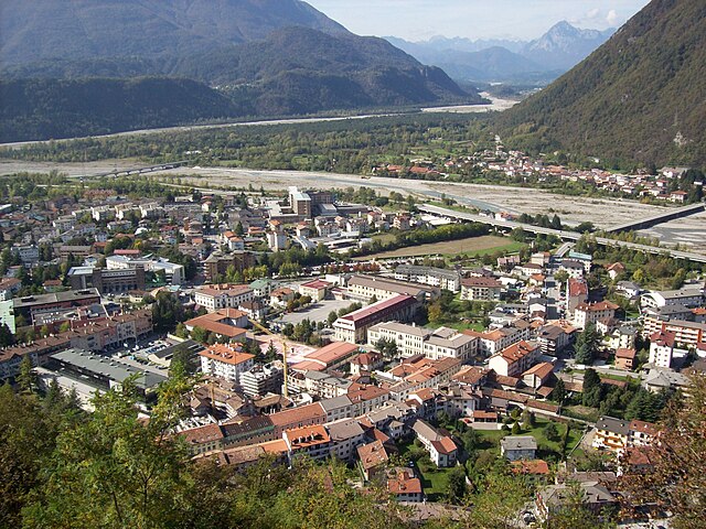
Villa Santina (Villa Santina)
.svg)
- Italian comune
 Hiking in Villa Santina
Villa Santina is a charming town located in the Friuli Venezia Giulia region of northeastern Italy, known for its stunning natural landscapes and outdoor activities, including hiking. Nestled in the Carnic Alps, the area offers a variety of trails suitable for different skill levels, making it an excellent destination for both novice and experienced hikers.
Hiking Trails
-
Val Fella: This picturesque valley features several trails, with options for easy walks and more challenging hikes. The area is known for its lush greenery, alpine meadows, and beautiful views of the surrounding mountains.
-
Carnic Alps Trail: This long-distance hiking route passes through the Carnic Alps, providing stunning panoramas and a chance to explore the diverse flora and fauna of the region. The trail is quite extensive, so plan segments that match your ability and interests.
-
Monte Muro: A popular hike that offers a rewarding summit with breathtaking views of the surrounding valleys and peaks. The trail is moderately challenging, making it a great option for those who are physically fit and looking for a bit of adventure.
-
Lake Timau: This easy hike leads you to a scenic alpine lake, perfect for families or those looking for a leisurely outing. The trail is relatively flat and offers a peaceful environment for picnicking and enjoying nature.
Best Time to Hike
The best times to hike in Villa Santina are late spring through early fall (May to September), when the weather is typically stable and the trails are clear of snow. Summer can be busy as many locals and tourists head into the mountains, especially in July and August.
Preparation Tips
- Check Weather Conditions: Mountain weather can change rapidly, so always check the forecast.
- Dress in Layers: Temperatures can vary, so layering is key for staying comfortable.
- Footwear: Wear sturdy, comfortable hiking boots that provide good ankle support.
- Hydration and Snacks: Bring plenty of water and snacks to keep your energy levels up during the hike.
- Trail Maps: Consider downloading or carrying a physical map of the trails. Some paths may not be well-marked.
Local Attractions
After your hike, explore the local culture in Villa Santina. Enjoy traditional Friulian cuisine in local restaurants, visit nearby historical sites, and take in the serene Alpine landscapes that define this beautiful region.
Whether you’re looking for a short stroll or a challenging trek, Villa Santina’s hiking options can cater to your preferences, allowing you to immerse yourself in the natural beauty of northern Italy.
- Country:

- Postal Code: 33029
- Local Dialing Code: 0433
- Licence Plate Code: UD
- Coordinates: 46° 25' 0" N, 12° 55' 0" E


- GPS tracks (wikiloc): [Link]
- AboveSeaLevel: 363 м m
- Area: 12.99 sq km
- Population: 2204
- Web site: http://www.comune.villasantina.ud.it/
- Wikipedia en: wiki(en)
- Wikipedia: wiki(it)
- Wikidata storage: Wikidata: Q53395
- Wikipedia Commons Category: [Link]
- Freebase ID: [/m/0gkbv0]
- GeoNames ID: Alt: [6538399]
- VIAF ID: Alt: [242731228]
- OSM relation ID: [79218]
- UN/LOCODE: [ITNTI]
- Digital Atlas of the Roman Empire ID: [43375]
- ISTAT ID: 030133
- Italian cadastre code: L909
Shares border with regions:
Enemonzo
- Italian comune
Hiking in Enemonzo
Enemonzo is a picturesque commune located in the Friuli Venezia Giulia region of northeastern Italy, known for its beautiful landscapes and outdoor activities, including hiking. Here are some highlights and tips for hiking in and around Enemonzo:...
- Country:
- Postal Code: 33020
- Local Dialing Code: 0433
- Licence Plate Code: UD
- Coordinates: 46° 24' 30" N, 12° 52' 46" E
- GPS tracks (wikiloc): [Link]
- AboveSeaLevel: 398 м m
- Area: 23.76 sq km
- Population: 1305
- Web site: [Link]


Lauco
- Italian comune
Hiking in Lauco
Lauco, a beautiful area located in the Friuli Venezia Giulia region of northeastern Italy, is known for its stunning landscapes, rich biodiversity, and scenic trails. Here are some key points to consider if you’re planning to hike in Lauco:...
- Country:
- Postal Code: 33029
- Local Dialing Code: 0433
- Licence Plate Code: UD
- Coordinates: 46° 25' 0" N, 12° 56' 0" E
- GPS tracks (wikiloc): [Link]
- AboveSeaLevel: 719 м m
- Area: 34.76 sq km
- Population: 726
- Web site: [Link]


Raveo
- Italian comune
Hiking in Raveo
Raveo, located in the Friuli Venezia Giulia region of northern Italy, offers a variety of beautiful hiking opportunities set against the backdrop of the stunning Friulian Alps. The area is known for its rich natural beauty, featuring lush forests, alpine meadows, and diverse wildlife, making it perfect for both casual walkers and experienced hikers....
- Country:
- Postal Code: 33029
- Local Dialing Code: 0433
- Licence Plate Code: UD
- Coordinates: 46° 26' 0" N, 12° 52' 0" E
- GPS tracks (wikiloc): [Link]
- AboveSeaLevel: 518 м m
- Area: 12.6 sq km
- Population: 446
- Web site: [Link]

Tolmezzo
- Italian comune
Hiking in Tolmezzo
Tolmezzo, located in the Carnia region of the Friuli Venezia Giulia area of northeastern Italy, is a fantastic destination for hiking enthusiasts. Surrounded by the stunning Carnic Alps and lush valleys, it offers a variety of trails catering to all experience levels, from beginners to seasoned hikers....
- Country:
- Postal Code: 33028
- Local Dialing Code: 0433 487911
- Licence Plate Code: UD
- Coordinates: 46° 24' 0" N, 13° 1' 0" E
- GPS tracks (wikiloc): [Link]
- AboveSeaLevel: 323 м m
- Area: 64.62 sq km
- Population: 10191
- Web site: [Link]


Verzegnis
- Italian comune
Hiking in Verzegnis
Verzegnis is a picturesque village located in the Friuli Venezia Giulia region of northeastern Italy. It's nestled in the Carnic Alps, which offer stunning landscapes, rich biodiversity, and a variety of hiking opportunities suitable for all levels of experience....
- Country:
- Postal Code: 33020
- Local Dialing Code: 0433
- Licence Plate Code: UD
- Coordinates: 46° 22' 59" N, 12° 58' 33" E
- GPS tracks (wikiloc): [Link]
- AboveSeaLevel: 407 м m
- Area: 39.33 sq km
- Population: 863
- Web site: [Link]