
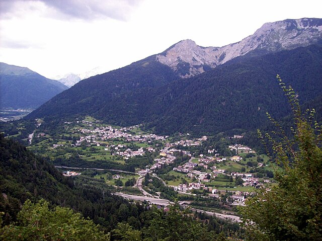
Tolmezzo (Tolmezzo)
.svg)
- Italian comune
 Hiking in Tolmezzo
Tolmezzo, located in the Carnia region of the Friuli Venezia Giulia area of northeastern Italy, is a fantastic destination for hiking enthusiasts. Surrounded by the stunning Carnic Alps and lush valleys, it offers a variety of trails catering to all experience levels, from beginners to seasoned hikers.
Key Hiking Trails:
-
Monte Arvenis: This trail provides a moderate hike with spectacular views of the surrounding Alps and valleys. The ascent can be quite rewarding, especially on clear days when you can see for miles.
-
Sella Chianzutan: A beautiful trail that takes you through alpine meadows and forests, leading to panoramic viewpoints. This route is great for enjoying nature and observing local flora and fauna.
-
Forni di Sotto to Casera Razzo: This is a more demanding hike that offers breathtaking scenery and a chance to see traditional alpine huts (casere). The views of the valley and mountains are particularly striking.
-
Cimbri Trail: This trail provides a cultural experience as it follows the historical routes of the Cimbri people, combining history with natural beauty.
Best Times to Hike:
- Spring (April to June): Wildflowers in bloom and vibrant greenery make this a picturesque time for hiking. Weather can be variable, but generally mild.
- Summer (July to September): Offers the best weather for mountain hikes, but trails can be busier. Early mornings are ideal to avoid the heat.
- Fall (October to November): Autumn colors add a stunning backdrop to the hikes. Fewer crowds make for a tranquil experience, although weather can be unpredictable.
What to Bring:
- Proper Footwear: Sturdy hiking boots with good grip are essential.
- Clothing Layers: Weather can change rapidly in the mountains. Dress in layers to adjust to temperature changes.
- Water and Snacks: Hydration is crucial, especially on longer hikes.
- Navigation Tools: Maps, GPS, or a hiking app to help guide you.
- First Aid Kit: Always good to have for safety.
Tips for Hiking in Tolmezzo:
- Check Weather Conditions: Before heading out, always check the weather. Conditions can change abruptly in the mountains.
- Respect Nature: Follow Leave No Trace principles to protect the environment.
- Know Your Limits: Choose trails that match your fitness level and experience.
Local Amenities:
Tolmezzo offers various accommodations, from hotels to guesthouses, making it a comfortable base for hikers. You can also find local restaurants serving traditional Friulian cuisine, which is a great way to replenish your energy after a day on the trails.
Overall, hiking in Tolmezzo is a rewarding experience, combining adventure with the beauty of nature and the rich cultural heritage of the region. Whether you’re looking for a challenging trek or a leisurely stroll, there’s a trail for everyone.
- Country:

- Postal Code: 33028
- Local Dialing Code: 0433 487911
- Licence Plate Code: UD
- Coordinates: 46° 24' 0" N, 13° 1' 0" E


- GPS tracks (wikiloc): [Link]
- AboveSeaLevel: 323 м m
- Area: 64.62 sq km
- Population: 10191
- Web site: http://www.comune.tolmezzo.ud.it/
- Wikipedia en: wiki(en)
- Wikipedia: wiki(it)
- Wikidata storage: Wikidata: Q53381
- Wikipedia Commons Gallery: [Link]
- Wikipedia Commons Category: [Link]
- Freebase ID: [/m/0f505f]
- GeoNames ID: Alt: [6540405]
- VIAF ID: Alt: [129034064]
- OSM relation ID: [79136]
- GND ID: Alt: [4119649-1]
- MusicBrainz area ID: [47132b70-33fd-4363-87d9-ae26c699d4a0]
- WOEID: [724961]
- UN/LOCODE: [ITTMO]
- ISTAT ID: 030121
- Italian cadastre code: L195
Shares border with regions:


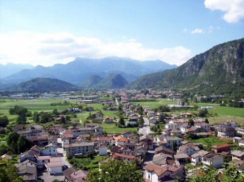
Amaro, Friuli
- Italian comune
Hiking in Amaro, Friuli
Amaro, located in the Friuli Venezia Giulia region of northern Italy, is a fantastic destination for hiking enthusiasts. Nestled in the foothills of the Julian Alps, it offers breathtaking scenery, diverse landscapes, and a variety of trails catering to different skill levels. Here are some key highlights for hiking in the area:...
- Country:
- Postal Code: 33020
- Local Dialing Code: 0433
- Licence Plate Code: UD
- Coordinates: 46° 22' 30" N, 13° 5' 47" E
- GPS tracks (wikiloc): [Link]
- AboveSeaLevel: 296 м m
- Area: 33.26 sq km
- Population: 857
- Web site: [Link]

Arta Terme
- Italian comune
Hiking in Arta Terme
Arta Terme, located in the Friuli Venezia Giulia region of northeastern Italy, is a beautiful destination for hiking enthusiasts. This picturesque area is surrounded by the Carnic Alps and offers a range of trails suitable for all levels, from beginners to experienced hikers....
- Country:
- Postal Code: 33022
- Local Dialing Code: 0433
- Licence Plate Code: UD
- Coordinates: 46° 29' 0" N, 13° 1' 0" E
- GPS tracks (wikiloc): [Link]
- AboveSeaLevel: 422 м m
- Area: 42.77 sq km
- Population: 2076
- Web site: [Link]


Cavazzo Carnico
- Italian comune
Hiking in Cavazzo Carnico
Cavazzo Carnico, located in the Friuli Venezia Giulia region of northeastern Italy, is a fantastic destination for hiking enthusiasts. Nestled between the beautiful Julian Alps and the Carnic Alps, the area is known for its stunning landscapes, diverse flora and fauna, and rich cultural heritage....
- Country:
- Postal Code: 33020
- Local Dialing Code: 0433
- Licence Plate Code: UD
- Coordinates: 46° 22' 0" N, 13° 2' 0" E
- GPS tracks (wikiloc): [Link]
- AboveSeaLevel: 290 м m
- Area: 39.44 sq km
- Population: 1024
- Web site: [Link]


Lauco
- Italian comune
Hiking in Lauco
Lauco, a beautiful area located in the Friuli Venezia Giulia region of northeastern Italy, is known for its stunning landscapes, rich biodiversity, and scenic trails. Here are some key points to consider if you’re planning to hike in Lauco:...
- Country:
- Postal Code: 33029
- Local Dialing Code: 0433
- Licence Plate Code: UD
- Coordinates: 46° 25' 0" N, 12° 56' 0" E
- GPS tracks (wikiloc): [Link]
- AboveSeaLevel: 719 м m
- Area: 34.76 sq km
- Population: 726
- Web site: [Link]


Moggio Udinese
- Italian comune
Hiking in Moggio Udinese
Moggio Udinese, located in the Friuli-Venezia Giulia region of northeastern Italy, is a charming destination for hiking enthusiasts. Nestled in the Julian Alps, the area is characterized by lush landscapes, picturesque valleys, and majestic mountain views. Here are some highlights and tips for hiking in and around Moggio Udinese:...
- Country:
- Postal Code: 33015
- Local Dialing Code: 0433
- Licence Plate Code: UD
- Coordinates: 46° 25' 0" N, 13° 12' 0" E
- GPS tracks (wikiloc): [Link]
- AboveSeaLevel: 341 м m
- Area: 142.44 sq km
- Population: 1703
- Web site: [Link]


Verzegnis
- Italian comune
Hiking in Verzegnis
Verzegnis is a picturesque village located in the Friuli Venezia Giulia region of northeastern Italy. It's nestled in the Carnic Alps, which offer stunning landscapes, rich biodiversity, and a variety of hiking opportunities suitable for all levels of experience....
- Country:
- Postal Code: 33020
- Local Dialing Code: 0433
- Licence Plate Code: UD
- Coordinates: 46° 22' 59" N, 12° 58' 33" E
- GPS tracks (wikiloc): [Link]
- AboveSeaLevel: 407 м m
- Area: 39.33 sq km
- Population: 863
- Web site: [Link]

Villa Santina
- Italian comune
Hiking in Villa Santina
Villa Santina is a charming town located in the Friuli Venezia Giulia region of northeastern Italy, known for its stunning natural landscapes and outdoor activities, including hiking. Nestled in the Carnic Alps, the area offers a variety of trails suitable for different skill levels, making it an excellent destination for both novice and experienced hikers....
- Country:
- Postal Code: 33029
- Local Dialing Code: 0433
- Licence Plate Code: UD
- Coordinates: 46° 25' 0" N, 12° 55' 0" E
- GPS tracks (wikiloc): [Link]
- AboveSeaLevel: 363 м m
- Area: 12.99 sq km
- Population: 2204
- Web site: [Link]


Zuglio
- Italian comune
Hiking in Zuglio
Zuglio, located in the Friuli Venezia Giulia region of Italy, is a charming destination for hiking enthusiasts. This area is steeped in history and natural beauty, making it a perfect spot for both leisurely walks and more challenging hikes....
- Country:
- Postal Code: 33020
- Local Dialing Code: 0433
- Licence Plate Code: UD
- Coordinates: 46° 27' 44" N, 13° 1' 30" E
- GPS tracks (wikiloc): [Link]
- AboveSeaLevel: 425 м m
- Area: 18.21 sq km
- Population: 583
- Web site: [Link]