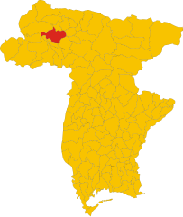
Raveo (Raveo)
.svg)
- Italian comune
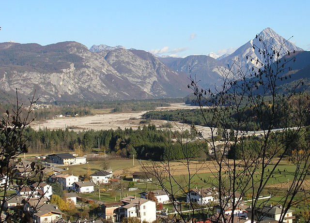
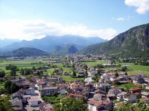
 Hiking in Raveo
Raveo, located in the Friuli Venezia Giulia region of northern Italy, offers a variety of beautiful hiking opportunities set against the backdrop of the stunning Friulian Alps. The area is known for its rich natural beauty, featuring lush forests, alpine meadows, and diverse wildlife, making it perfect for both casual walkers and experienced hikers.
Key Hiking Areas and Trails:
-
Alpi Carniche: Raveo serves as a gateway to the Carnic Alps, where numerous trails range in difficulty. You can find well-marked paths that lead to breathtaking vantage points offering panoramic views of the surrounding mountains.
-
Monte Croce di Comelico: A popular hike in the area, this trail offers a rewarding experience for hikers who venture to the summit. The hike is moderate in difficulty and typically takes a few hours round-trip.
-
Foresta di Tarvisio: Although a little farther from Raveo, this forest area is fantastic for hiking enthusiasts. The lush woods provide a lovely setting, with trails that vary in length and difficulty.
-
Cascate di Cjase di Raveo: A lesser-known gem, this hike leads to beautiful waterfalls. It’s a shorter but picturesque trek perfect for families or those looking for a leisurely day out.
Tips for Hiking in Raveo:
- Best Time to Go: Late spring to early autumn (May to October) is ideal for hiking, as the weather is generally mild and the trails are accessible.
- Gear: Wear sturdy hiking boots, and dress in layers to accommodate changing weather conditions. Don’t forget essentials like a map, water, snacks, and sunscreen.
- Local Guide: If you're unfamiliar with the area, consider hiring a local guide who can provide insights into the flora, fauna, and cultural history of the region.
- Respect Nature: Follow Leave No Trace principles to preserve the natural beauty of the trails.
Cultural Highlights:
While hiking in Raveo, you can also enjoy the local culture. The town is known for its beautiful architecture and historical landmarks. After your hike, consider visiting local restaurants to sample traditional Friulian cuisine.
Overall, hiking in Raveo provides a delightful mix of natural beauty, adventure, and cultural experiences, making it a great destination for outdoor enthusiasts.
- Country:

- Postal Code: 33029
- Local Dialing Code: 0433
- Licence Plate Code: UD
- Coordinates: 46° 26' 0" N, 12° 52' 0" E


- GPS tracks (wikiloc): [Link]
- AboveSeaLevel: 518 м m
- Area: 12.6 sq km
- Population: 446
- Web site: http://www.comune.raveo.ud.it
- Wikipedia en: wiki(en)
- Wikipedia: wiki(it)
- Wikidata storage: Wikidata: Q53330
- Wikipedia Commons Category: [Link]
- Freebase ID: [/m/0gk9w5]
- GeoNames ID: Alt: [6538388]
- VIAF ID: Alt: [239225304]
- OSM relation ID: [79213]
- WOEID: [721536]
- Digital Atlas of the Roman Empire ID: [43370]
- ISTAT ID: 030089
- Italian cadastre code: H200
Shares border with regions:
Enemonzo
- Italian comune
Hiking in Enemonzo
Enemonzo is a picturesque commune located in the Friuli Venezia Giulia region of northeastern Italy, known for its beautiful landscapes and outdoor activities, including hiking. Here are some highlights and tips for hiking in and around Enemonzo:...
- Country:
- Postal Code: 33020
- Local Dialing Code: 0433
- Licence Plate Code: UD
- Coordinates: 46° 24' 30" N, 12° 52' 46" E
- GPS tracks (wikiloc): [Link]
- AboveSeaLevel: 398 м m
- Area: 23.76 sq km
- Population: 1305
- Web site: [Link]


Lauco
- Italian comune
Hiking in Lauco
Lauco, a beautiful area located in the Friuli Venezia Giulia region of northeastern Italy, is known for its stunning landscapes, rich biodiversity, and scenic trails. Here are some key points to consider if you’re planning to hike in Lauco:...
- Country:
- Postal Code: 33029
- Local Dialing Code: 0433
- Licence Plate Code: UD
- Coordinates: 46° 25' 0" N, 12° 56' 0" E
- GPS tracks (wikiloc): [Link]
- AboveSeaLevel: 719 м m
- Area: 34.76 sq km
- Population: 726
- Web site: [Link]

Ovaro
- Italian comune
Hiking in Ovaro
Ovaro is a beautiful town located in the Friuli Venezia Giulia region of northeastern Italy. It's situated in the Carnic Alps and is surrounded by stunning natural landscapes, making it a great destination for hiking enthusiasts. Here are some key points to consider when hiking in and around Ovaro:...
- Country:
- Postal Code: 33025
- Local Dialing Code: 0433
- Licence Plate Code: UD
- Coordinates: 46° 29' 0" N, 12° 52' 0" E
- GPS tracks (wikiloc): [Link]
- AboveSeaLevel: 525 м m
- Area: 57.9 sq km
- Population: 1875
- Web site: [Link]

Socchieve
- Italian comune
Hiking in Socchieve
Socchieve, a picturesque area in the Julian Alps of Italy, is known for its stunning natural landscapes and diverse hiking trails suitable for a variety of skill levels. Here’s what you can expect when hiking in Socchieve:...
- Country:
- Postal Code: 33020
- Local Dialing Code: 0433
- Licence Plate Code: UD
- Coordinates: 46° 23' 48" N, 12° 50' 53" E
- GPS tracks (wikiloc): [Link]
- AboveSeaLevel: 480 м m
- Area: 66.12 sq km
- Population: 896
- Web site: [Link]

Villa Santina
- Italian comune
Hiking in Villa Santina
Villa Santina is a charming town located in the Friuli Venezia Giulia region of northeastern Italy, known for its stunning natural landscapes and outdoor activities, including hiking. Nestled in the Carnic Alps, the area offers a variety of trails suitable for different skill levels, making it an excellent destination for both novice and experienced hikers....
- Country:
- Postal Code: 33029
- Local Dialing Code: 0433
- Licence Plate Code: UD
- Coordinates: 46° 25' 0" N, 12° 55' 0" E
- GPS tracks (wikiloc): [Link]
- AboveSeaLevel: 363 м m
- Area: 12.99 sq km
- Population: 2204
- Web site: [Link]