Vineuil (Vineuil)

- commune in Loir-et-Cher, France
- Country:

- Postal Code: 41350
- Coordinates: 47° 34' 50" N, 1° 22' 21" E


- GPS tracks (wikiloc): [Link]
- Area: 22.34 sq km
- Population: 7724
- Web site: http://vineuil41.org/
- Wikipedia en: wiki(en)
- Wikipedia: wiki(fr)
- Wikidata storage: Wikidata: Q1167527
- Wikipedia Commons Category: [Link]
- Freebase ID: [/m/03qd2xn]
- GeoNames ID: Alt: [6613964]
- SIREN number: [214102956]
- BnF ID: [15259569r]
- Library of Congress authority ID: Alt: [no2004115942]
- INSEE municipality code: 41295
Shares border with regions:


Saint-Gervais-la-Forêt
- commune in Loir-et-Cher, France
- Country:
- Postal Code: 41350
- Coordinates: 47° 34' 8" N, 1° 21' 36" E
- GPS tracks (wikiloc): [Link]
- Area: 8.97 sq km
- Population: 3224
- Web site: [Link]


Huisseau-sur-Cosson
- commune in Loir-et-Cher, France
- Country:
- Postal Code: 41350
- Coordinates: 47° 35' 33" N, 1° 27' 10" E
- GPS tracks (wikiloc): [Link]
- Area: 22.79 sq km
- Population: 2279
- Web site: [Link]


La Chaussée-Saint-Victor
- commune in Loir-et-Cher, France
- Country:
- Postal Code: 41260
- Coordinates: 47° 36' 50" N, 1° 21' 55" E
- GPS tracks (wikiloc): [Link]
- Area: 6.63 sq km
- Population: 4510
- Web site: [Link]
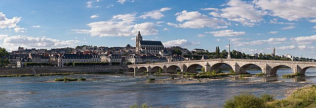
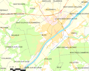
Blois
- commune in Loir-et-Cher, France
- Country:
- Postal Code: 41000
- Coordinates: 47° 35' 35" N, 1° 19' 38" E
- GPS tracks (wikiloc): [Link]
- AboveSeaLevel: 73 м m
- Area: 37.46 sq km
- Population: 45710
- Web site: [Link]


Saint-Claude-de-Diray
- commune in Loir-et-Cher, France
- Country:
- Postal Code: 41350
- Coordinates: 47° 36' 55" N, 1° 24' 57" E
- GPS tracks (wikiloc): [Link]
- Area: 9.17 sq km
- Population: 1762
- Web site: [Link]
Mont-près-Chambord
- commune in Loir-et-Cher, France
- Country:
- Postal Code: 41250
- Coordinates: 47° 33' 46" N, 1° 27' 44" E
- GPS tracks (wikiloc): [Link]
- Area: 28.51 sq km
- Population: 3244


Saint-Denis-sur-Loire
- commune in Loir-et-Cher, France
- Country:
- Postal Code: 41000
- Coordinates: 47° 37' 30" N, 1° 23' 11" E
- GPS tracks (wikiloc): [Link]
- Area: 12.4 sq km
- Population: 838