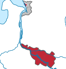
Wesermarsch (Landkreis Wesermarsch)


- district in Lower Saxony, Germany
 Hiking in Wesermarsch
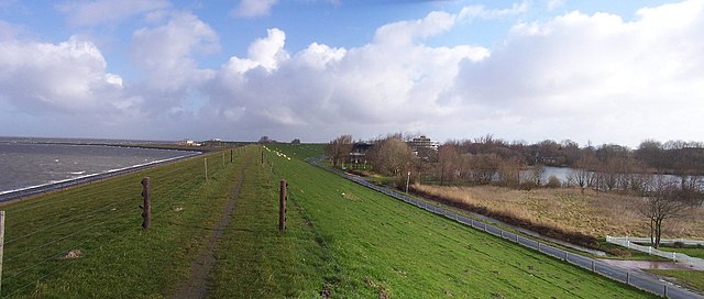
Wesermarsch is a fascinating region in Lower Saxony, Germany, known for its flat landscapes, unique marsh ecosystems, and rich cultural heritage. While it may not be as mountainous as other hiking destinations, it offers a variety of hiking trails suitable for all levels, especially for those who enjoy tranquil walks in nature and picturesque views.
Key Features of Hiking in Wesermarsch:
-
Scenic Trails: The region features numerous well-marked hiking trails that showcase the beautiful marshlands, rivers, and lush greenery. Trails such as the "Weserhöhenweg" provide scenic views along the Weser River, making for a pleasant outdoor experience.
-
Wetland Ecosystem: Wesermarsch is home to a unique wetland ecosystem that attracts various bird species, making it a great spot for birdwatching while hiking. Keep an eye out for migratory birds and native species in the marshes.
-
Cultural Heritage: As you hike through the region, you will encounter quaint villages, traditional farms, and historical sites. This combination of nature and culture allows for immersive experiences, such as visiting local museums or enjoying regional cuisine at nearby cafes.
-
Flat Terrain: The flat terrain of Wesermarsch makes it accessible for hikers of all skill levels, including families with children. It's an excellent destination for leisurely strolls or longer walks without the challenge of steep inclines.
-
Cycle Integration: Many of the hiking trails are also suitable for cycling, which can be a great way to explore the area further and take in more of the stunning landscapes.
Tips for Hiking in Wesermarsch:
-
Best Time to Visit: Late spring and early autumn are ideal for hiking due to milder temperatures and beautiful scenery. However, be mindful of rainfall, as the region can be quite wet throughout the year.
-
Prepare for Weather Changes: Weather in the marsh can change quickly, so dress in layers and bring waterproof gear to stay comfortable.
-
Respect Nature: Stay on marked paths to protect the delicate marsh ecosystem. Be mindful of local wildlife and plants.
-
Stay Hydrated and Pack Snacks: Bring water and snacks, especially if you plan on hiking longer trails or exploring isolated areas.
-
Local Guidance: Consider checking with local tourist information centers for maps, trail conditions, and guided hiking opportunities.
Overall, Wesermarsch offers a peaceful and scenic setting for hikers looking to enjoy the beauty of northern Germany's marshlands. Whether you're a seasoned hiker or looking for a leisurely day out in nature, you'll find plenty of opportunities to explore and appreciate this unique region.
- Country:

- Capital: Brake
- Licence Plate Code: BRA
- Coordinates: 53° 19' 48" N, 8° 19' 48" E


- GPS tracks (wikiloc): [Link]
- Area: 821.87 sq km
- Population: 89282
- Web site: http://www.landkreis-wesermarsch.de
- Wikipedia en: wiki(en)
- Wikipedia: wiki(de)
- Wikidata storage: Wikidata: Q5948
- Wikipedia Commons Category: [Link]
- Freebase ID: [/m/012w7j]
- Freebase ID: [/m/012w7j]
- Freebase ID: [/m/012w7j]
- GeoNames ID: Alt: [3221099]
- GeoNames ID: Alt: [3221099]
- GeoNames ID: Alt: [3221099]
- VIAF ID: Alt: [145238611]
- VIAF ID: Alt: [145238611]
- VIAF ID: Alt: [145238611]
- OSM relation ID: [3853102]
- OSM relation ID: [3853102]
- OSM relation ID: [3853102]
- GND ID: Alt: [4065716-4]
- GND ID: Alt: [4065716-4]
- GND ID: Alt: [4065716-4]
- archINFORM location ID: [8272]
- archINFORM location ID: [8272]
- archINFORM location ID: [8272]
- TGN ID: [7076836]
- TGN ID: [7076836]
- TGN ID: [7076836]
- ISNI: Alt: [0000 0001 2336 9597]
- ISNI: Alt: [0000 0001 2336 9597]
- ISNI: Alt: [0000 0001 2336 9597]
- National Library of Israel ID: [000141158]
- National Library of Israel ID: [000141158]
- National Library of Israel ID: [000141158]
- NUTS code: [DE94G]
- NUTS code: [DE94G]
- NUTS code: [DE94G]
- German district key: 03461
- German district key: 03461
- German district key: 03461
Includes regions:


Berne
- municipality in Lower Saxony, Germany
Hiking in Berne
It seems there's a bit of confusion, as Berne is actually the capital city of Switzerland, not Germany. However, if you're interested in hiking in the area around Berne, I can provide some information about that!...
- Country:
- Postal Code: 27804
- Local Dialing Code: 04406
- Licence Plate Code: BRA
- Coordinates: 53° 11' 0" N, 8° 29' 0" E
- GPS tracks (wikiloc): [Link]
- AboveSeaLevel: 6 м m
- Area: 85.20 sq km
- Population: 6821
- Web site: [Link]


Brake
- municipality in Lower Saxony, Germany
Hiking in Brake
Brake is a quaint town in Lower Saxony, Germany, located on the banks of the Weser River. While it may not be as widely known for hiking as some other areas in Germany, it does offer some enjoyable outdoor experiences and scenic routes for hiking enthusiasts....
- Country:
- Postal Code: 26911–26919
- Local Dialing Code: 04401
- Licence Plate Code: BRA
- Coordinates: 53° 20' 0" N, 8° 29' 0" E
- GPS tracks (wikiloc): [Link]
- AboveSeaLevel: 3 м m
- Area: 38.30 sq km
- Population: 15016
- Web site: [Link]


Nordenham
- municipality in Lower Saxony, Germany
Hiking in Nordenham
Nordenham, located in Lower Saxony, Germany, is a charming town situated along the River Weser. While it may not be as well-known for hiking as some other areas in Germany, there are still several opportunities for outdoor enthusiasts to enjoy nature and explore the scenic landscapes around the region. Here are some highlights for hiking in and around Nordenham:...
- Country:
- Postal Code: 26954
- Local Dialing Code: 04731
- Licence Plate Code: BRA
- Coordinates: 53° 30' 0" N, 8° 28' 0" E
- GPS tracks (wikiloc): [Link]
- AboveSeaLevel: 2 м m
- Area: 87.32 sq km
- Population: 26294
- Web site: [Link]

Butjadingen
- municipality in Lower Saxony, Germany
Hiking in Butjadingen
Butjadingen is a beautiful region located in Lower Saxony, Germany, along the North Sea coast. While it is more known for its flat landscapes, dykes, and coastal scenery, it offers some delightful hiking opportunities for nature lovers and outdoor enthusiasts....
- Country:
- Postal Code: 26969
- Local Dialing Code: 04736; 04735; 04733
- Licence Plate Code: BRA
- Coordinates: 53° 32' 50" N, 8° 20' 6" E
- GPS tracks (wikiloc): [Link]
- AboveSeaLevel: 2 м m
- Area: 129.02 sq km
- Population: 6180
- Web site: [Link]


Elsfleth
- municipality in Lower Saxony, Germany
Hiking in Elsfleth
Elsfleth, a small town in Lower Saxony, Germany, is located near the banks of the Weser River and offers a unique hiking experience with scenic views and a calm environment. While it may not be as widely known for extensive hiking trails compared to larger national parks, you can still enjoy several outdoor activities in and around the area....
- Country:
- Postal Code: 26931
- Local Dialing Code: 04485; 04483; 04404
- Licence Plate Code: BRA
- Coordinates: 53° 14' 0" N, 8° 28' 0" E
- GPS tracks (wikiloc): [Link]
- AboveSeaLevel: 3 м m
- Area: 115.15 sq km
- Population: 9094
- Web site: [Link]


Ovelgönne
- municipality in Lower Saxony, Germany
Hiking in Ovelgönne
Ovelgönne, located in the district of Wesermarsch in Lower Saxony, Germany, offers a picturesque environment for hiking with scenic views of the surrounding countryside and waterways. Although it may not be as popular as some larger hiking destinations, it provides a charming setting for those looking to explore the natural beauty of the region....
- Country:
- Postal Code: 26939
- Local Dialing Code: 04483; 04480; 04401
- Licence Plate Code: BRA
- Coordinates: 53° 21' 0" N, 8° 24' 0" E
- GPS tracks (wikiloc): [Link]
- AboveSeaLevel: 4 м m
- Area: 123.81 sq km
- Population: 5361
- Web site: [Link]


Lemwerder
- municipality in Lower Saxony, Germany
Hiking in Lemwerder
Lemwerder is a small town located in Lower Saxony, Germany, along the banks of the Weser River. While not as widely recognized for hiking as some other regions, it offers some pleasant outdoor activities and potential hiking experiences, particularly for those who enjoy walking in flat, scenic, and rural areas....
- Country:
- Postal Code: 27809
- Local Dialing Code: 0421
- Licence Plate Code: BRA
- Coordinates: 53° 10' 0" N, 8° 37' 0" E
- GPS tracks (wikiloc): [Link]
- AboveSeaLevel: 1 м m
- Area: 36.38 sq km
- Population: 6996
- Web site: [Link]


Stadland
- municipality in Lower Saxony, Germany
Hiking in Stadland
Stadland, a municipality in Lower Saxony, Germany, offers a variety of landscapes ideal for hiking enthusiasts. While it may not be as famous as some other hiking destinations, it features scenic rural paths, coastal trails, and opportunities to enjoy the natural beauty of the North Sea and the countryside....
- Country:
- Postal Code: 26937; 26936; 26935
- Local Dialing Code: 04731; 04734; 04737; 04732
- Licence Plate Code: BRA
- Coordinates: 53° 23' 0" N, 8° 23' 0" E
- GPS tracks (wikiloc): [Link]
- AboveSeaLevel: 1 м m
- Area: 113.38 sq km
- Population: 7511
- Web site: [Link]


Jade
- municipality in Lower Saxony, Germany
Hiking in Jade
Jade, located in Lower Saxony, Germany, offers a range of outdoor activities, including hiking, thanks to its picturesque landscapes and coastal proximity. Here are some highlights and tips for hiking in the Jade region:...
- Country:
- Postal Code: 26349
- Local Dialing Code: 04480; 04455; 04454
- Licence Plate Code: BRA
- Coordinates: 53° 20' 40" N, 8° 14' 25" E
- GPS tracks (wikiloc): [Link]
- AboveSeaLevel: 5 м m
- Area: 93.57 sq km
- Population: 5820
- Web site: [Link]
Shares border with regions:

Bremen
- city in the Bremen federated state, Germany
Hiking in Bremen
Bremen, while primarily known for its rich history and vibrant cultural scene, doesn't have the extensive hiking trails commonly found in more mountainous regions of Germany. However, there are some lovely outdoor areas and walking opportunities nearby that can satisfy those looking for a hiking experience....
- Country:
- Postal Code: 28779; 28777; 28759; 28757; 28755; 28719; 28717; 28359; 28357; 28355; 28329; 28327; 28325; 28309; 28307; 28279; 28277; 28259; 28239; 28237; 28219; 28217; 28215; 28213; 28211; 28209; 28207; 28205; 28203; 28201; 28199; 28197; 28195
- Local Dialing Code: 0421
- Licence Plate Code: HB
- Coordinates: 53° 4' 37" N, 8° 48' 32" E
- GPS tracks (wikiloc): [Link]
- AboveSeaLevel: 6 м m
- Area: 326.18 sq km
- Population: 568006
- Web site: [Link]


Bremerhaven
- German city in the Free Hanseatic City of Bremen
Hiking in Bremerhaven
Bremerhaven, located in northern Germany along the North Sea coast, is not typically known as a major hiking destination compared to areas with more rugged terrain. However, it offers some pleasant walking and hiking opportunities, particularly for those who enjoy coastal scenery and urban exploration....
- Country:
- Postal Code: 27501–27580; 2850
- Local Dialing Code: 0471
- Licence Plate Code: HB
- Coordinates: 53° 33' 0" N, 8° 35' 0" E
- GPS tracks (wikiloc): [Link]
- AboveSeaLevel: 2 м m
- Area: 93.66 sq km
- Population: 113034
- Web site: [Link]


Oldenburg
- town in Lower Saxony, Germany
Hiking in Oldenburg
Oldenburg, located in Lower Saxony, Germany, offers a variety of hiking opportunities that cater to different skill levels and preferences. The region is known for its beautiful landscapes, parks, and diverse ecosystems. Here are some highlights and tips for hiking in and around Oldenburg:...
- Country:
- Postal Code: 26001–26135
- Local Dialing Code: 0441
- Licence Plate Code: OL
- Coordinates: 53° 8' 38" N, 8° 12' 50" E
- GPS tracks (wikiloc): [Link]
- AboveSeaLevel: 4 м m
- Area: 103.09 sq km
- Population: 165711
- Web site: [Link]


Delmenhorst
- city in Lower Saxony, Germany
Hiking in Delmenhorst
Delmenhorst is a town located in Lower Saxony, Germany, near Bremen. While it may not be as widely known for hiking as some other regions, it offers several opportunities for outdoor walking and nature exploration. Here are some insights about hiking in and around Delmenhorst:...
- Country:
- Postal Code: 27749–27755
- Local Dialing Code: 04221
- Licence Plate Code: DEL
- Coordinates: 53° 3' 2" N, 8° 37' 54" E
- GPS tracks (wikiloc): [Link]
- AboveSeaLevel: 7 м m
- Area: 62.45 sq km
- Population: 77045
- Web site: [Link]

Cuxhaven
- German district of Lower Saxony
Hiking in Cuxhaven
Cuxhaven, located in Lower Saxony, Germany, offers a unique hiking experience with its combination of coastal landscapes, nature reserves, and historical sites. Here are some highlights of hiking in the Cuxhaven district:...
- Country:
- Capital: Cuxhaven
- Licence Plate Code: CUX
- Coordinates: 53° 40' 12" N, 8° 49' 48" E
- GPS tracks (wikiloc): [Link]
- AboveSeaLevel: 5 м m
- Area: 2057.78 sq km
- Population: 198670
- Web site: [Link]


Osterholz
- district in Lower Saxony, Germany
Hiking in Osterholz
Osterholz, located in Lower Saxony, Germany, offers a variety of hiking opportunities for outdoor enthusiasts. The region is characterized by its beautiful landscapes, including forests, heathlands, and rivers, providing a picturesque setting for hikers. Here are some highlights and tips for hiking in Osterholz:...
- Country:
- Capital: Osterholz-Scharmbeck
- Licence Plate Code: OHZ
- Coordinates: 53° 15' 0" N, 8° 49' 48" E
- GPS tracks (wikiloc): [Link]
- AboveSeaLevel: 3 м m
- Area: 650.73 sq km
- Population: 112695
- Web site: [Link]


Friesland
- district of Germany
Hiking in Friesland
Friesland, a province in the northern Netherlands, offers a unique and beautiful landscape for hiking enthusiasts. Known for its picturesque lake districts, lush meadows, and iconic windmills, Friesland combines natural beauty with cultural heritage....
- Country:
- Licence Plate Code: FRI
- Coordinates: 53° 30' 0" N, 8° 0' 0" E
- GPS tracks (wikiloc): [Link]
- Area: 608.00 sq km
- Population: 97900
- Web site: [Link]

Ammerland
- district in Lower Saxony, Germany
Hiking in Ammerland
Ammerland, located in Lower Saxony, Germany, is a scenic region known for its beautiful landscapes, lush greenery, and peaceful lakes. While it may not be as mountainous as other regions in Germany, it offers a variety of trails that are perfect for hiking enthusiasts of all levels. Here are some key aspects to consider when hiking in Ammerland:...
- Country:
- Licence Plate Code: WST
- Coordinates: 53° 15' 0" N, 7° 55' 12" E
- GPS tracks (wikiloc): [Link]
- AboveSeaLevel: 7 м m
- Area: 728.00 sq km
- Population: 122698
- Web site: [Link]


Oldenburg
- district of Lower Saxony, Germany
Hiking in Oldenburg
Oldenburg District, located in Lower Saxony, Germany, offers a variety of landscapes and trails suitable for hiking enthusiasts. While it may not be as mountainous as other regions in Germany, its scenic countryside, woodlands, and lakes provide a wonderful backdrop for outdoor activities....
- Country:
- Licence Plate Code: OL
- Coordinates: 53° 0' 0" N, 8° 25' 12" E
- GPS tracks (wikiloc): [Link]
- AboveSeaLevel: 25 м m
- Area: 1063.00 sq km
- Population: 129484
- Web site: [Link]